Liste der Einträge im National Register of Historic Places im Monroe County (Illinois)

Die Liste der Einträge im National Register of Historic Places im Monroe County in Illinois führt alle acht Bauwerke und historischen Stätten im Monroe County auf, die in das National Register of Historic Places aufgenommen wurden.[1]
Legende
| NRHP | Historic Place |
|---|---|
| HD | Historic District |
Aktuelle Einträge
| [2] | Name[3] | Bild | Eintragsdatum | Lage | Ort | Beschreibung |
|---|---|---|---|---|---|---|
| 1 | Fountain Creek Bridge | 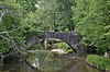 | 1978 ID-Nr. 78001176 | Südlich der IL 156 am Westrand von Waterloo 38° 19′ 33″ N, 90° 11′ 45″ W38.325833333333-90.195833333333 | Waterloo | |
| 2 | Gundlach-Grosse House |  | 1978 ID-Nr. 78001173 | 625 North Main Street 38° 26′ 53″ N, 90° 12′ 18″ W38.448055555556-90.205 | Columbia | |
| 3 | Lunsford-Pulcher Archeological Site |  | 1973 ID-Nr. 73000712 | Adresse nicht veröffentlicht | Columbia | |
| 4 | Maeystown Historic District |  | 1978 ID-Nr. 78001174 | IL 7 38° 13′ 34″ N, 90° 14′ 1″ W38.226111111111-90.233611111111 | Maeystown | |
| 5 | Stephen W. Miles House | 1982 ID-Nr. 78001175 | Nordwestlich von Valmeyer abseits der IL 156 38° 18′ 28″ N, 90° 15′ 54″ W38.307777777778-90.265 | Valmeyer | ||
| 6 | Capt. James Moore Farmstead | 1982 ID-Nr. 82005204 | South Church Street 38° 19′ 44″ N, 90° 8′ 59″ W38.328888888889-90.149722222222 | Waterloo | ||
| 7 | Peterstown House |  | 1977 ID-Nr. 77000489 | 275 North Main Street 38° 20′ 31″ N, 90° 9′ 3″ W38.341944444444-90.150833333333 | Waterloo | |
| 8 | Waterloo Historic District |  | 1978 ID-Nr. 78001177 | 517 South Main Street 38° 20′ 6″ N, 90° 9′ 6″ W38.335-90.151666666667 | Waterloo |
Siehe auch
Einzelnachweise
- ↑ Auszug aus dem National Register of Historic Places - Monroe County Abgerufen am 18. Januar 2013
- ↑ Die Nummerierung in dieser Listenspalte ist an der vom National Park Service vorgelegten Reihenfolge der Einträge orientiert; die Farben unterscheiden verschiedene Schutzgebietstypen des Nationalparksystems mit landesweiter Bedeutung (z. B. National Historic Landmarks) von den sonstigen Einträgen im National Register of Historic Places.
- ↑ National Register Information System. In: National Register of Historic Places. National Park Service, abgerufen am 9. Juli 2010 (englisch).
- Karte mit allen Koordinaten:
- OSM
- WikiMap

Einträge im National Register of Historic Places in Illinois
National Register of Historic Places in Illinois
Adams | Alexander | Bond | Boone | Brown | Bureau | Calhoun | Carroll | Cass | Champaign | Christian | Clark | Clay | Clinton | Coles | Cook (inkl. Chicago) | Crawford | Cumberland | DeKalb | DeWitt | Douglas | DuPage | Edgar | Edwards | Effingham | Fayette | Ford | Franklin | Fulton | Gallatin | Greene | Grundy | Hamilton | Hancock | Hardin | Henderson | Henry | Iroquois | Jackson | Jasper | Jefferson | Jersey | Jo Daviess | Johnson | Kane | Kankakee | Kendall | Knox | LaSalle | Lake | Lawrence | Lee | Livingston | Logan | Macon | Macoupin | Madison | Marion | Marshall | Mason | Massac | McDonough | McHenry | McLean | Menard | Mercer | Monroe | Montgomery | Morgan | Moultrie | Ogle | Peoria | Perry | Piatt | Pike | Pope | Pulaski | Putnam | Randolph | Richland | Rock Island | Saline | Sangamon | Schuyler | Scott | Shelby | St. Clair | Stark | Stephenson | Tazewell | Union | Vermilion | Wabash | Warren | Washington | Wayne | White | Whiteside | Will | Williamson | Winnebago | Woodford


