Liste von Leuchttürmen in England
Die Liste von Leuchttürmen in England nennt aktive und ehemalige Leuchttürme und Leuchtfeuer (der englische Begriff Lighthouse ist umfassender) in England. Sie enthält keine Objekte aus Irland, Schottland, Wales und auch keine Feuerschiffe.
Liste
| Name | Region | Gewässer | Position | Baujahr | Turmhöhe | Feuerhöhe | Kennung | Bild |
|---|---|---|---|---|---|---|---|---|
| Anvil Point Lighthouse | Dorset | Ärmelkanal | 50° 35′ 30,7″ N, 1° 57′ 35,6″ W50.59187-1.95989 | 1881 | 12 m | 45 m | Fl.W.10s |  |
| Bamburgh Lighthouse | Northumberland | Nordsee | 55° 36′ 59,5″ N, 1° 43′ 27,2″ W55.61652-1.72423 | 1910 | 9 m | 13 m | Oc(2)WRG.8s |  |
| Beach Lighthouse (Fleetwood) | Lancashire | Morecambe Bay | 53° 55′ 42,8″ N, 3° 0′ 32,7″ W53.92855-3.00907 | 1840 | 13 m | 14 m | Fl.G.2s |  |
| Beachy Head Lighthouse | East Sussex | Ärmelkanal | 50° 44′ 1,3″ N, 0° 14′ 29,3″ O50.73370.24148 | 1902 | 33 m | 31 m | Fl(2)W.20s |  |
| Berry Head Lighthouse | Devon | Ärmelkanal | 50° 23′ 58,5″ N, 3° 29′ 0,3″ W50.39958-3.48343 | 1906 | 5 m | 58 m | Fl(2)W.15s | 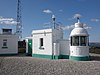 |
| Bishop Rock Lighthouse | Scilly-Inseln | Keltische See | 49° 52′ 22,3″ N, 6° 26′ 44,1″ W49.87285-6.44557 | 1858 1887 | 49 m | 44 m | Fl(2)W.15s |  |
| Bow Creek Lighthouse | London | Themse | 51° 30′ 27,6″ N, 0° 0′ 29,8″ O51.507680.00829 | 1866 | unbekannt | unbekannt | gelöscht (1988) | 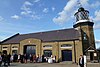 |
| Bull Point Lighthouse | Devon | Bristolkanal | 51° 11′ 56,7″ N, 4° 12′ 4,2″ W51.19909-4.20118 | 1975 | 11 m | 54 m | Fl(3)W.10s |  |
| Coquet Lighthouse | Northumberland | Nordsee | 55° 20′ 2,2″ N, 1° 32′ 21,7″ W55.33395-1.53937 | 1841 | 22 m | 25 m | Fl(3)WR.20s | 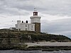 |
| Cromer Lighthouse | Norfolk | Nordsee | 52° 55′ 28,9″ N, 1° 18′ 59,4″ O52.92471.3165 | 1833 | 18 m | 84 m | Fl.W.5s |  |
| Crow Point Lighthouse | Devon | Bristolkanal | 51° 3′ 58,1″ N, 4° 11′ 23,4″ W51.06615-4.18982 | 1954 | 5 m | 8 m | Fl.WR.2.5s |  |
| Dungeness Lighthouse | Kent | Straße von Dover | 50° 54′ 48,4″ N, 0° 58′ 33,3″ O50.913450.97592 | 1961 | 43 m | 40 m | Fl.W.10s |  |
| Eddystone Lighthouse | Devon | Ärmelkanal | 50° 10′ 50,6″ N, 4° 15′ 56,2″ W50.18072-4.2656 | 1882 | 49 m | 41 m | Fl(2)W.10s | 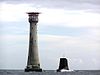 |
| Farne Island Lighthouse | Northumberland | Nordsee | 55° 36′ 55,2″ N, 1° 39′ 20,3″ W55.61533-1.65564 | 1811 | 13 m | 27 m | Fl(2)WR.15s |  |
| Flamborough Head Lighthouse | East Riding of Yorkshire | Nordsee | 54° 6′ 58,9″ N, 0° 4′ 57,6″ W54.11637-0.08267 | 1806 | 27 m | 65 m | Fl(4)W.15s |  |
| Godrevy Lighthouse | Cornwall | Keltische See | 50° 14′ 32,8″ N, 5° 24′ 1,4″ W50.24245-5.4004 | 1859 | 26 m | 28 m | Fl.WR.10s | 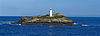 |
| Guile Point Lighthouse | Northumberland | Nordsee | 55° 39′ 29,4″ N, 1° 47′ 35,5″ W55.65817-1.7932 | 1859 | 21 m | 9 m | Oc.WRG.6s |  |
| Hartland Point Lighthouse | Devon | Keltische See | 51° 1′ 19,1″ N, 4° 31′ 31,4″ W51.02197-4.52538 | 1874 | 18 m | 37 m | Fl(6)W.15s | 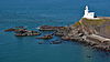 |
| Heugh Hill Lighthouse | Northumberland | Nordsee | 55° 40′ 5,5″ N, 1° 47′ 58,4″ W55.6682-1.79956 | 1826 | 8 m | 24 m | Oc.WRG.6s |  |
| Hilbre Island Lighthouse | Merseyside | Irische See | 53° 22′ 59,3″ N, 3° 13′ 42,8″ W53.38315-3.22856 | 1927 | 3 m | 14 m | Fl.R.3s |  |
| Hurst Point Lighthouse | Hampshire | Solent | 50° 42′ 28,6″ N, 1° 33′ 1,2″ W50.70795-1.55033 | 1867 | 26 m | 23 m | Fl(4)WR.15s Dir.Iso.WRG.4s | 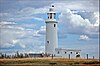 |
| Lizard Lighthouse | Cornwall | Ärmelkanal | 49° 57′ 36,7″ N, 5° 12′ 7,6″ W49.9602-5.20212 | 1751 | 19 m | 70 m | Fl.W.3s |  |
| Longships Lighthouse | Cornwall | Keltische See | 50° 4′ 0,7″ N, 5° 44′ 48,4″ W50.06687-5.74677 | 1875 | 35 m | 35 m | Fl(2)WR.10s |  |
| Longstone Lighthouse | Northumberland | Nordsee | 55° 38′ 37,5″ N, 1° 36′ 39″ W55.64375-1.61082 | 1826 | 26 m | 23 m | Fl.W.20s |  |
| Lowestoft Lighthouse | Suffolk | Nordsee | 52° 29′ 13,1″ N, 1° 45′ 21,2″ O52.486981.7559 | 1874 | 16 m | 37 m | Fl.W.15s |  |
| Lundy North Lighthouse | Devon | Bristolkanal | 51° 12′ 6,2″ N, 4° 40′ 38,2″ W51.20173-4.67728 | 1897 | 17 m | 48 m | Fl.W.15s |  |
| Lundy Old Lighthouse | Devon | Bristolkanal | 51° 10′ 2″ N, 4° 40′ 24,1″ W51.16721-4.67337 | 1820 | 29 m | 164 m | gelöscht (1897) |  |
| Lundy South Lighthouse | Devon | Bristolkanal | 51° 9′ 43,4″ N, 4° 39′ 20,9″ W51.16205-4.6558 | 1897 | 16 m | 53 m | Fl.W.5s |  |
| Lynmouth Foreland Lighthouse | Devon | Bristolkanal | 51° 14′ 43,6″ N, 3° 47′ 10,7″ W51.24545-3.7863 | 1900 | 15 m | 67 m | Fl(4)W.15s |  |
| Nab Tower Lighthouse | Isle of Wight | Solent | 50° 40′ 4,5″ N, 0° 57′ 9,3″ W50.66792-0.95258 | 1918 | 17 m | 17 m | Fl.W.10s |  |
| Needles Lighthouse | Isle of Wight | Solent | 50° 39′ 44″ N, 1° 35′ 30,3″ W50.66223-1.59175 | 1859 | 31 m | 24 m | Oc(2)WRG.20s |  |
| Pendeen Lighthouse | Cornwall | Keltische See | 50° 9′ 53,9″ N, 5° 40′ 17,7″ W50.16497-5.67159 | 1900 | 17 m | 59 m | Fl(4)W.15s |  |
| Peninnis Lighthouse | Scilly-Inseln | Keltische See | 49° 54′ 16,7″ N, 6° 18′ 12,8″ W49.90463-6.30355 | 1911 | 14 m | 36 m | Fl.W.20s |  |
| Pharos Lighthouse (Fleetwood) | Lancashire | Morecambe Bay | 53° 55′ 35,4″ N, 3° 0′ 27″ W53.92651-3.00751 | 1840 | 27 m | 28 m | Fl.G.4s |  |
| Plover Scar Lighthouse | Lancashire | Morecambe Bay | 53° 58′ 53,4″ N, 2° 52′ 57,3″ W53.98151-2.88259 | 1847 | 8 m | 6 m | Fl.W.2s |  |
| Portland Bill Lighthouse | Dorset | Ärmelkanal | 50° 30′ 50,8″ N, 2° 27′ 23,1″ W50.51411-2.45641 | 1906 | 41 m | 43 m | Fl(4)W.20s |  |
| Round Island Lighthouse | Scilly-Inseln | Keltische See | 49° 58′ 44,4″ N, 6° 19′ 22,6″ W49.979-6.32295 | 1887 | 19 m | 55 m | Fl.W.10s |  |
| Royal Sovereign Lighthouse | East Sussex | Ärmelkanal | 50° 43′ 27,2″ N, 0° 26′ 5,2″ O50.724230.43477 | 1971 | 36 m | 28 m | Fl.W.20s |  |
| Smeaton's Tower | Devon | Plymouth Sound | 50° 21′ 51,7″ N, 4° 8′ 30,9″ W50.36435-4.14192 | 1759 | 22 m | unbekannt | gelöscht (1877) |  |
| Southwold Lighthouse | Suffolk | Nordsee | 52° 19′ 37,9″ N, 1° 40′ 52,8″ O52.32721.68134 | 1887 | 31 m | 37 m | Fl.W.10s |  |
| St. Anthony Lighthouse | Cornwall | Ärmelkanal | 50° 8′ 28,1″ N, 5° 0′ 58″ W50.14115-5.01612 | 1835 | 19 m | 22 m | Iso.WR.15s |  |
| St Bees Lighthouse | Cumbria | Solway Firth | 54° 30′ 49,1″ N, 3° 38′ 12″ W54.51365-3.63668 | 1822 | 17 m | 102 m | Fl(2)W.20s |  |
| St. Catherine′s Lighthouse | Isle of Wight | Ärmelkanal | 50° 34′ 32,2″ N, 1° 17′ 52,4″ W50.57561-1.2979 | 1838 | 27 m | 41 m | Fl.W.5s |  |
| St. Mary’s Lighthouse | Tyne and Wear | Nordsee | 55° 4′ 18,1″ N, 1° 26′ 58,1″ W55.07169-1.44947 | 1898 | 46 m | unbekannt | gelöscht (1984) |  |
| Start Point Lighthouse | Devon | Ärmelkanal | 50° 13′ 21,2″ N, 3° 38′ 32,1″ W50.22255-3.64225 | 1836 | 28 m | 62 m | Fl(3)W.10s |  |
| Tater Du Lighthouse | Cornwall | Ärmelkanal | 50° 3′ 8,6″ N, 5° 34′ 38,8″ W50.0524-5.57745 | 1965 | 15 m | 34 m | Fl(3)W.15s |  |
| Trevose Head Lighthouse | Cornwall | Keltische See | 50° 32′ 57,2″ N, 5° 2′ 6,7″ W50.54923-5.0352 | 1847 | 27 m | 62 m | Fl.W.7.5s |  |
| Whitby Lighthouse | Yorkshire | Nordsee | 54° 28′ 40,2″ N, 0° 34′ 5,7″ W54.47783-0.56826 | 1858 | 13 m | 73 m | Fl.WR.5s |  |
| Wolf Rock Lighthouse | Cornwall | Keltische See | 49° 56′ 43,2″ N, 5° 48′ 33″ W49.94532-5.80917 | 1869 | 41 m | 34 m | Fl.W.15s | 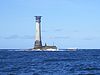 |
| Wyre Light | Lancashire | Morecambe Bay | 53° 57′ 9,1″ N, 3° 1′ 47,9″ W53.95252-3.02997 | 1840 | 5 m | 14 m | gelöscht (1979) |  |
Weblinks
Commons: Leuchttürme in England – Sammlung von Bildern, Videos und Audiodateien
Portal: Leuchtfeuer – Übersicht von Wikipedia-Inhalten zum Thema Leuchtfeuer (Diskussion)

- Russ Rowlett: The Lighthouse Directory. University of North Carolina at Chapel Hill, abgerufen am 6. September 2016 (englisch).
- All Lighthouses. Trinity House, abgerufen am 6. September 2016 (englisch).
- Karte mit allen Koordinaten:
- OSM
- WikiMap
Albanien • Aserbaidschan • Belgien • Bosnien und Herzegowina • Bulgarien • Deutschland • Dänemark • Estland • Finnland • Frankreich • Georgien • Griechenland • Island • Irland • Italien • Kasachstan • Kroatien • Lettland • Litauen • Malta • Monaco • Montenegro • Niederlande • Norwegen • Österreich • Polen • Portugal • Rumänien • Russland • Slowenien • Spanien • Schweden • Schweiz • Türkei • Ukraine • Vereinigtes Königreich (England • Schottland • Wales • Nordirland) • Zypern
Gebiete mit begrenzter Anerkennung als Staat: Abchasien • Nordzypern
Abhängige Gebiete und andere Territorien: Åland • Färöer • Gibraltar • Guernsey • Jersey • Isle of Man • Svalbard


