Uteute
| Uteute | |||
|---|---|---|---|
| |||
| Koordinaten | 4° 41′ 37,82″ N, 160° 22′ 41,3″ W4.69384-160.37814Koordinaten: 4° 41′ 37,82″ N, 160° 22′ 41,3″ W | ||
 | |||
| Basisdaten | |||
| Staat | Kiribati | ||
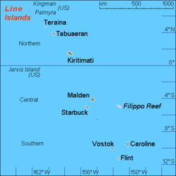
| Inselgruppe | Linieinseln | ||
| ISO 3166-2 | KI-L | ||
| Fläche | 0,1 km² | ||
| Einwohner | 55 (2020) | ||
| Dichte | 550 Ew./km² | ||
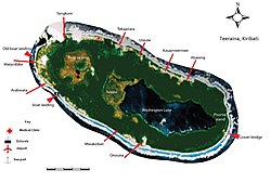 beschriftetes Satellitenfoto von Teraina | |||


Uteute ist ein Ort im nördlichen Teil des pazifischen Archipels der Line Islands nahe dem Äquator im Staat Kiribati mit einer Fläche von 0,1 km².[1] 2020 wurden 55 Einwohner gezählt.[2]
Geographie
Uteute liegt zusammen mit Abaiang, Kauamwemwe und Kaaitara an der Nordküste der Insel Teraina (früher auch Washington, New York oder Prospectus Island genannt).[3] Haupterwerbszweige sind Kokosanbau und Fischerei. Im Süden liegen der Washington Lake und das Torfmoor East Bog.
Klima
Das Klima ist tropisch heiß, wird jedoch von ständig wehenden Winden gemäßigt. Ebenso wie die anderen Orte der südlichen Line Islands wird Uteute gelegentlich von Zyklonen heimgesucht.
Einzelnachweise
- ↑ Teeraina Island 2008 Socio-Economic Profile. Band 1. Republic of Kiribati – Ministry of Internal and Social Affairs, 2008, Table 2: Population Density by village, S. 22 (englisch, web.archive.org [PDF; 1,9 MB; abgerufen am 27. Juni 2024]).
- ↑ Kiribati – Population and Housing Census 2020. Value 2003. In: microdata.pacificdata.org. Pazifische Gemeinschaft, 25. Juni 2024, abgerufen am 7. September 2024 (englisch).
- ↑ Teeraina Island 2008 Socio-Economic Profile. Band 1. Republic of Kiribati – Ministry of Internal and Social Affairs, 2008, 2.1.1. Location, Size and Land Area, S. 12 (englisch, web.archive.org [PDF; 1,9 MB; abgerufen am 27. Juni 2024]).


