Al Aamriya
Village in Al Rayyan, Qatar
Al Aamriya العامرية | |
|---|---|
Village | |
| 24°49′15″N 51°04′37″E / 24.82073°N 51.07696°E / 24.82073; 51.07696 | |
| Country |  Qatar Qatar |
| Municipality | Al Rayyan |
| Zone no. | Zone 96 |
| District no. | 719 |
| Area [1] | |
| • Total | 30.05 km2 (11.60 sq mi) |
Al Aamriya (Arabic: العامرية) is a village in southern Qatar, located in the municipality of Al Rayyan.[2][3]
The village of Umm Hawta, to the north, is nearby.[3]
Etymology
The village was named in honor of an esteemed resident known as "Al-Aamri" who lived in the village until his death.[3]
Gallery
-
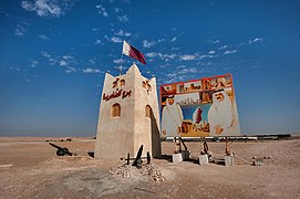 Entrance to Al Aamriya

References
- ^ "District Area Map". Ministry of Development Planning and Statistics. Retrieved 30 November 2019.
- ^ "Qatar Development Atlas - Part 1" (PDF). Ministry of Development Planning and Statistics. 2010. p. 10. Archived from the original (PDF) on 18 July 2020. Retrieved 2 January 2019.
- ^ a b c "District map". The Centre for Geographic Information Systems of Qatar. Archived from the original on 24 November 2020. Retrieved 2 January 2019.
- v
- t
- e
 Al Rayyan Municipality
Capital: Al Rayyan City
- Al Gharrafa
- Al Seej
- Al Themaid
- Bani Hajer
- Gharrafat Al Rayyan
- Izghawa
- Rawdat Egdaim
- Rawdat Al Jahhaniya
- Umm Al Afaei
- Al Luqta
- Al Shagub
- Fereej Al Zaeem
- Lebday
- Old Al Rayyan
- Al Aziziya
- Al Mearad
- Al Sailiya
- Al Waab
- Bu Sidra
- Fereej Al Manaseer
- Fereej Al Murra
- Fereej Al Soudan
- Muaither
- New Fereej Al Ghanim
- Abu Hamour
- Ain Khaled
- Al Mamoura
- Bu Samra
- Fereej Al Asiri
- Mesaimeer
- New Fereej Al Khulaifat
- Labour City
- Umm Al Seneem
- Mebaireek
- Al Hemaila
- Al Khaldiya
- Al Mukaynis
- Ummahat Owaina
- Al Karaana
- Al Rekayya
- Baida Al Gaa
- Jariyan Al Batnah
- Jaww Basheer
- Umm Al Suwab
- Abu Samra
- Al Aamriya
- Eglat Faisal
- Lusail West
- Umm Hawta
 Category:Al Rayyan
 | This Qatari location article is a stub. You can help Wikipedia by expanding it. |
- v
- t
- e


