Al Qassar
District in Ad-Dawhah, Qatar
Al Qassar القصار | |
|---|---|
District | |
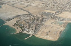 Aerial view of parts of Al Qassar 61 (left) and Al Qassar 66, separated by Katara Street, in 2010 | |
25°21′03″N 51°31′39″E / 25.3509°N 51.5275°E / 25.3509; 51.5275 | |
| Country |  Qatar Qatar |
| Municipality | Ad-Dawhah |
| Zone | Zone 61, Zone 66 |
| District no. | 106 |
| Area [1] | |
| • Total | 2.8 km2 (1.1 sq mi) |
Al Qassar (Arabic: القصار, romanized: Al Qaşşār; also spelled to as Al Gassar) is a seafront district on Qatar's eastern coast, located in the municipality of Ad Dawhah.[2][3]
In the 2015 census it formed Zone 61 with Al Dafna and Zone 66 with Onaiza and Leqtaifiya.[2]
History
Al Qassar was built on land that was reclaimed in the 1970s and 1980s after extensive dredging. As part of a masterplan by the Qatari government, the entire area, which came to be known as West Bay, was to be developed as Qatar's new business center.[4]
Etymology
In Arabic, qassar is a word used for small black rocks found around beaches. The district received its name because of its high concentration of these rocks.[3]
Geography
Al Qassar borders the following districts:[3]
- West Bay Lagoon and Onaiza to the west, separated by Lusail Street.
- The Pearl to the east, separated by the Persian Gulf.
- Al Dafna to the south, separated by Dafna Street.
Transport
Currently, the underground Al Qassar Metro Station is under construction, having been launched during Phase 1. Once completed, it will be part of Doha Metro's Red Line North.[5]
Archaeology
Al Qassar was found to have rock carvings of human and animals by an excavation team in 1979. Most of them have been eroded beyond recognition. Stone blocks containing still-recognizable carvings were cut off and transported to the Qatar National Museum for preservation.[6]
One petroglyph, which contains two different panels carved by more than one individual, depicts two horse riders and a camel. The riders, one behind the other, are holding lances in their upraised hands. The second rider appears to be chasing the first, as his lance is pointed towards the other rider's back.[7] The figure of the second rider is leaning in a forward position, with the lance projecting from his upper body. In front of the riders is a camel with incomplete body features. Archaeologist Muhammad Abdul Nayeem tentatively dated the carving to the second millennium BC.[8]
Gallery
-
 View from the St. Regis Hotel in Al Qassar

References
- ^ "District Area Map". Ministry of Development Planning and Statistics. Retrieved 1 March 2019.
- ^ a b "2015 population census" (PDF). Ministry of Development Planning and Statistics. Archived from the original (PDF) on 14 February 2017. Retrieved 29 December 2018.
- ^ a b c "District map". The Centre for Geographic Information Systems of Qatar. Archived from the original on 24 November 2020. Retrieved 30 December 2018.
- ^ Chomowicz, P. (2021). "The Urban Imaginary in Doha, Qatar". Histories of Postwar Architecture. 5 (8): 126. doi:10.6092/issn.2611-0075/11910.
- ^ "QAR Metro". arcgis.com. Archived from the original on 4 December 2019. Retrieved 17 March 2019.
- ^ Abdul Nayeem, Muhammad (1998). Qatar Prehistory and Protohistory from the Most Ancient Times (Ca. 1,000,000 to End of B.C. Era). Hyderabad Publishers. p. 222. ISBN 9788185492049.
- ^ Abdul Nayeem, p. 231.
- ^ Abdul Nayeem (1998), p. 232.
- v
- t
- e
- Al Bidda
- Al Dafna
- Ad Dawhah al Jadidah
- Al Egla
- Al Hilal
- Al Jasrah
- Al Kharayej
- Al Khulaifat
- Al Mansoura
- Al Markhiya
- Al Messila
- Al Mirqab
- Al Najada
- Al Qassar
- Al Rufaa
- Al Sadd
- Al Souq
- Al Tarfa
- Al Thumama
- Barahat Al Jufairi
- Dahl Al Hamam
- Doha International Airport
- Doha Port
- Duhail
- Fereej Abdel Aziz
- Fereej Al Asmakh
- Fereej Al Nasr
- Fereej Bin Durham
- Fereej Bin Mahmoud
- Fereej Bin Omran
- Fereej Kulaib
- Fereej Mohammed Bin Jasim
- Hamad Medical City
- Hazm Al Markhiya
- Industrial Area
- Jabal Thuaileb
- Jelaiah
- Jeryan Nejaima
- Lejbailat
- Lekhwair
- Leqtaifiya
- Madinat Khalifa North
- Madinat Khalifa South
- Musheireb
- Najma
- New Al Hitmi
- New Al Mirqab
- New Salata
- Nuaija
- Old Airport
- Old Al Ghanim
- Old Al Hitmi
- Old Salata
- Onaiza
- Ras Abu Aboud
- Ras Abu Fontas
- Rawdat Al Khail
- Rumeilah
- Umm Ghuwailina
- Umm Lekhba
- Wadi Al Banat
- Wadi Al Sail
- West Bay
- See also: Zones of Qatar
 | This Qatari location article is a stub. You can help Wikipedia by expanding it. |
- v
- t
- e


