Auce Municipality
Municipality of Latvia
Former municipality in Latvia
Auce Municipality Auces novads | |
|---|---|
Former municipality | |
 Flag  Coat of arms | |
 | |
| Country |  Latvia Latvia |
| Dissolved | 2021 |
| Centre | Auce |
| Area [1] | |
| • Total | 516.97 km2 (199.60 sq mi) |
| • Land | 503.25 km2 (194.31 sq mi) |
| • Water | 13.72 km2 (5.30 sq mi) |
| Population (2021)[2] | |
| • Total | 6,025 |
| • Density | 12/km2 (30/sq mi) |
| Website | www |
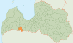
Auce Municipality (Latvian: Auces novads) was a municipality in Semigallia, Latvia. The municipality was formed in 2009 by merging Bēne parish, Lielauce parish, Ukri parish, Vītiņi parish, Īle parish and Auce town with its countryside territory the administrative centre being Auce.
On 1 July 2021, Auce Municipality ceased to exist and its territory was merged into Dobele Municipality.[3]
Twin towns — sister cities
Auce was twinned with:[4]
 Akmenė, Lithuania
- Joniškis, Lithuania
 Bryansk, Russia


See also
References
- ^ Central Statistical Bureau of Latvia https://data.stat.gov.lv/pxweb/lv/OSP_PUB/START__ENV__DR__DRT/DRT010/. Retrieved 25 February 2021.
{{cite web}}: Missing or empty|title=(help) - ^ Central Statistical Bureau of Latvia https://data.stat.gov.lv/pxweb/lv/OSP_PUB/START__POP__IR__IRS/IRD060/. Retrieved 15 June 2021.
{{cite web}}: Missing or empty|title=(help) - ^ "Administratīvo teritoriju un apdzīvoto vietu likums". LIKUMI.LV (in Latvian). Retrieved 2024-08-08.
- ^ "Sadarbības partneri". auce.lv (in Latvian). Auces novads. Retrieved 2019-09-16.
- v
- t
- e
Former first-level administrative divisions of Latvia (2009–2021)

- Aglona
- Aizkraukle
- Aizpute
- Aknīste
- Aloja
- Alsunga
- Alūksne
- Amata
- Ape
- Auce
- Ādaži
- Babīte
- Baldone
- Baltinava
- Balvi
- Bauska
- Beverīna
- Brocēni
- Burtnieki
- Carnikava
- Cesvaine
- Cēsis
- Cibla
- Dagda
- Daugavpils
- Dobele
- Dundaga
- Durbe
- Engure
- Ērgļi
- Garkalne
- Grobiņa
- Gulbene
- Iecava
- Ikšķile
- Ilūkste
- Inčukalns
- Jaunjelgava
- Jaunpiebalga
- Jaunpils
- Jelgava
- Jēkabpils
- Kandava
- Kārsava
- Kocēni
- Koknese
- Krāslava
- Krimulda
- Krustpils
- Kuldīga
- Ķegums
- Ķekava
- Lielvārde
- Limbaži
- Līgatne
- Līvāni
- Lubāna
- Ludza
- Madona
- Mazsalaca
- Mālpils
- Mārupe
- Mērsrags
- Naukšēni
- Nereta
- Nīca
- Ogre
- Olaine
- Ozolnieki
- Pārgauja
- Pāvilosta
- Pļaviņas
- Preiļi
- Priekule
- Priekuļi
- Rauna
- Rēzekne
- Riebiņi
- Roja
- Ropaži
- Rucava
- Rugāji
- Rundāle
- Rūjiena
- Salacgrīva
- Sala
- Salaspils
- Saldus
- Saulkrasti
- Sēja
- Sigulda
- Skrīveri
- Skrunda
- Smiltene
- Stopiņi
- Strenči
- Talsi
- Tērvete
- Tukums
- Vaiņode
- Valka
- Varakļāni
- Vārkava
- Vecpiebalga
- Vecumnieki
- Ventspils
- Viesīte
- Viļaka
- Viļāni
- Zilupe
56°30′00″N 22°57′00″E / 56.5000°N 22.9500°E / 56.5000; 22.9500
| Authority control databases: National |
|
|---|
 | This Semigallia location article is a stub. You can help Wikipedia by expanding it. |
- v
- t
- e


