Blue Mountains (Niger)
Mountain range in Niger
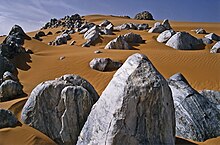
The Blue Mountains (French: Montagnes Bleus, Tamasheq: Izouzaouene, Izouzaoenehe)[1] are an outcrop off the northeastern section of the Aïr Massif in Niger, about 100 km ENE of the town of Iférouane and 30 km NE of the Tezerik oasis. Isolated from the main massif by dunes of the Erg Temet and a flat gravelly desert pavement plain, the rocky outcrop from the desert rises to a height of 924m, almost 300m over the surrounding topography.[2] The area is in Aïr and Ténéré National Nature Reserve, which is a UNESCO World Heritage Site. The mountains themselves are also within the smaller Aïr and Ténéré Addax Sanctuary. They are characterised by cipollino marble outcroppings, which give the hills a bluish tint. Despite their relative remoteness, they became a tourist destination during the upsurge of desert tourism in the late 1990s and early 2000s.
References
- ^ Bourseiller, Philippe; Bernus, Edmond; Hagedorn, Eliane (2004). Sahara Geheimnisse der Wüste (First German ed.). München. ISBN 978-3-89660-243-5.
{{cite book}}: CS1 maint: location missing publisher (link)[page needed] - ^ Geels, Jolijn (2006). Niger. Chalfont St Peter, Bucks / Guilford, CT: Bradt UK / Globe Pequot Press. pp. 178, 191–92. ISBN 978-1-84162-152-4.
Further reading
- Decalo, Samuel (1997). Historical Dictionary of the Niger (3rd ed.). Boston & Folkestone: Scarecrow Press. ISBN 0-8108-3136-8.[page needed]
- IGN Carte Touristique 85029 Niger (1) (Map). 1:2000000. IGN (Paris)/IGNN (Niamey). 1994. ISBN 978-2-11-850291-1. Archived from the original on 2008-10-07.
19°34′43″N 9°12′28″E / 19.57861°N 9.20778°E / 19.57861; 9.20778
- v
- t
- e
Major African geological formations
- Major plates: African Plate
- Minor plates: Somali Plate
- Microplates: Lwandle Plate
- Madagascar Plate
- Rovuma Plate
- Seychelles Plate
- Victoria Microplate
- Aswa Dislocation
- Broodkop Shear Zone
- Central African Shear Zone
- Chuan Shear Zones
- Foumban Shear Zone
- Kandi Fault Zone
- Mwembeshi Shear Zone
- Todi Shear Zone
- Western Meseta Shear Zone
- Afar Triangle
- Anza trough
- Bahr el Arab rift
- Benue Trough
- Blue Nile rift
- East African Rift
- Gulf of Suez Rift
- Lamu Embayment
- Melut Basin
- Muglad Basin
- Red Sea Rift
- Sangha Aulacogen
- Atbara rift
- Urema Valley
- West and Central African Rift System
- White Nile rift
- Angola Basin
- Aoukar
- Blue Nile Basin
- Chad Basin
- Congo Basin
- Douala Basin
- El Djouf
- Karoo Basin
- Gabon Basin
- Iullemmeden Basin
- Kufra Basin
- Murzuq Basin
- Niger Delta Basin
- Ogaden Basin
- Orange River Basin
- Ouled Abdoun Basin
- Owambo Basin
- Reggane Basin
- Rio del Rey Basin
- Sirte Basin
- Somali Coastal Basin
- Taoudeni Basin
- Tanzania Coastal Basin
- Tindouf Basin
- Turkana Basin
- Aïr Mountains
- Atlas Mountains
- Aurès Mountains
- Bambouk Mountains
- Blue Mountains
- Cameroon line
- Central Pangean Mountains
- Chaillu Mountains
- Drakensberg
- Eastern Arc Mountains
- Eastern Rift mountains
- Ethiopian Highlands
- Great Escarpment
- Great Karas Mountains
- Guinea Highlands
- Hoggar Mountains
- Imatong Mountains
- Jebel Uweinat
- Loma Mountains
- Mandara Mountains
- Marrah Mountains
- Mitumba Mountains
- Nuba Mountains
- Rif Mountains
- Rwenzori Mountains
- Sankwala Mountains
- Serra da Leba
- Serra da Chela
- Teffedest Mountains
- Tibesti Mountains
 | This Niger location article is a stub. You can help Wikipedia by expanding it. |
- v
- t
- e


