Boddinstraße (Berlin U-Bahn)
| Preceding station | Berlin U-Bahn | Following station | ||
|---|---|---|---|---|
| Hermannplatz towards Wittenau | U8 | Leinestraße towards Hermannstraße | ||
Location | |
|---|---|
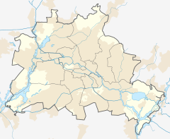
  Boddinstraße Location within Berlin |
Boddinstraße is a Berlin U-Bahn station located on the U8. It is located below Hermannstrasse at the intersection of Boddinstrasse in the Neukölln district. The station, opened in 1927, is one of the oldest on the line and is operated by the Berlin Transport Company (BVG) under the abbreviation Bo. The station's name comes from Hermann Boddin, mayor of the community from 1874 to 1907 and later the mayor of Rixdorf, today's district of Neukölln.[2]
History
Planning began in 1912 for an underground line along the course of what is now U8. After the initial stages were interrupted by World War I, the work progressed in the mid-1920s. The architects of the stations were Alfred Grenander and Alfred Fehse. The basic structure of the static was based on the underground stations belonging to the North-South Railway (today's U6 line), which opened in 1923.
The station was opened on 17 July 1927. At that time trains could only go one station further to Leinestraße. By 1928 the line was extended to Hermannstraße. Grey tiles on the walls and blue tiles on the columns are the main attributes of this station.[3]
Operations came to a standstill on 23 April 1945, following Allied bombing. Only three weeks later, operations resumed between Boddinstraße and Schönleinstraße. Three days later, it continued south to Leinestraße as well. The station was one of the first Berlin subway stations to reopen after the war.
The toilet facility closed in the 1960s and fell into disrepair. No institution would take responsibility, so neither modernization or demolition of the facility happened for a long time. Finally, it was demolished in 2007.[4]
In 2012, the BVG announced a complete renovation of the station, including adjustments to make it accessible. On 29 November 2013 an elevator went into operation and the platform has been accessible since then.
References
- ^ "Der VBB-Tarif: Aufteilung des Verbundgebietes in Tarifwaben und Tarifbereiche" (PDF). Verkehrsbetrieb Potsdam. Verkehrsverbund Berlin-Brandenburg. 1 January 2017. Archived from the original (PDF) on 27 October 2020. Retrieved 25 November 2019.
- ^ kaupertmedia. "Boddinstraße 1-66 in Berlin - KAUPERTS". berlin.kauperts.de (in German). Retrieved 2021-05-20.
- ^ J. Meyer-Kronthaler: Berlins U-Bahnhöfe. be.bra Verlag (1996)
- ^ Claudia Fuchs: Niemand will das Örtchen. Herrenloser Schandfleck am U-Bahnhof Boddinstraße. In: Berliner Zeitung, 30. September 1995
External links
- v
- t
- e

- Warschauer Straße
- Stralauer Tor (dismantled)
- Schlesisches Tor
- Görlitzer Bahnhof
- Kottbusser Tor
- Prinzenstraße
- Hallesches Tor
- Möckernbrücke
- Gleisdreieck
- Kurfürstenstraße
- Nollendorfplatz
- Wittenbergplatz
- Kurfürstendamm
- Uhlandstraße
- Pankow
- Vinetastraße
- Schönhauser Allee
- Eberswalder Straße
- Senefelderplatz
- Rosa-Luxemburg-Platz
- Alexanderplatz
- Klosterstraße
- Märkisches Museum
- Spittelmarkt
- Hausvogteiplatz
- Stadtmitte
- Mohrenstraße
- Potsdamer Platz
- Mendelssohn-Bartholdy-Park
- Gleisdreieck
- Bülowstraße
- Nollendorfplatz
- Wittenbergplatz
- Zoologischer Garten
- Ernst-Reuter-Platz
- Deutsche Oper
- Bismarckstraße
- Sophie-Charlotte-Platz
- Kaiserdamm
- Theodor-Heuss-Platz
- Neu-Westend
- Olympia-Stadion
- Ruhleben
- Warschauer Straße
- Stralauer Tor (dismantled)
- Schlesisches Tor
- Görlitzer Bahnhof
- Kottbusser Tor
- Prinzenstraße
- Hallesches Tor
- Möckernbrücke
- Gleisdreieck
- Kurfürstenstraße
- Nollendorfplatz
- Wittenbergplatz
- Augsburger Straße
- Nürnberger Platz (dismantled)
- Spichernstraße
- Hohenzollernplatz
- Fehrbelliner Platz
- Heidelberger Platz
- Rüdesheimer Platz
- Breitenbachplatz
- Podbielskiallee
- Dahlem-Dorf
- Freie Universität (Thielplatz)
- Oskar-Helene-Heim
- Onkel Toms Hütte
- Krumme Lanke
- Nollendorfplatz
- Viktoria-Luise-Platz
- Bayerischer Platz
- Rathaus Schöneberg
- Innsbrucker Platz
- Hauptbahnhof
- Bundestag
- Brandenburger Tor
- Unter den Linden
- Museumsinsel
- Rotes Rathaus
- Alexanderplatz
- Schillingstraße
- Strausberger Platz
- Weberwiese
- Frankfurter Tor
- Samariterstraße
- Frankfurter Allee
- Magdalenenstraße
- Lichtenberg
- Friedrichsfelde
- Tierpark
- Biesdorf-Süd
- Elsterwerdaer Platz
- Wuhletal
- Kaulsdorf Nord
- Kienberg (Gärten der Welt)
- Cottbusser Platz
- Hellersdorf
- Louis-Lewin-Straße
- Hönow
- Alt-Tegel
- Borsigwerke
- Holzhauser Straße
- Otisstraße
- Scharnweberstraße
- Kurt-Schumacher-Platz
- Afrikanische Straße
- Rehberge
- Seestraße
- Leopoldplatz
- Wedding
- Reinickendorfer Straße
- Schwartzkopffstraße
- Naturkundemuseum
- Oranienburger Tor
- Friedrichstraße
- Unter den Linden
- Französische Straße (closed)
- Stadtmitte
- Kochstraße
- Hallesches Tor
- Mehringdamm
- Platz der Luftbrücke
- Paradestraße
- Tempelhof
- Alt Tempelhof
- Kaiserin-Augusta-Straße
- Ullsteinstraße
- Westphalweg
- Alt-Mariendorf
- Rathaus Spandau
- Altstadt Spandau
- Zitadelle
- Haselhorst
- Paulsternstraße
- Rohrdamm
- Siemensdamm
- Halemweg
- Jakob-Kaiser-Platz
- Jungfernheide
- Mierendorffplatz
- Richard-Wagner-Platz
- Bismarckstraße
- Wilmersdorfer Straße
- Adenauerplatz
- Konstanzer Straße
- Fehrbelliner Platz
- Blissestraße
- Berliner Straße
- Bayerischer Platz
- Eisenacher Straße
- Kleistpark
- Yorckstraße
- Möckernbrücke
- Mehringdamm
- Gneisenaustraße
- Südstern
- Hermannplatz
- Rathaus Neukölln
- Karl-Marx-Straße
- Neukölln
- Grenzallee
- Blaschkoallee
- Parchimer Allee
- Britz-Süd
- Johannisthaller Chaussee
- Lipschitzallee
- Wutzkyallee
- Zwickauer Damm
- Rudow
- Wittenau
- Rathaus Reinickendorf
- Karl-Bonhoeffer-Nervenklinik
- Lindauer Allee
- Paracelsus-Bad
- Residenzstraße
- Franz-Neumann-Platz
- Osloer Straße
- Pankstraße
- Gesundbrunnen
- Voltastraße
- Bernauer Straße
- Rosenthaler Platz
- Weinmeisterstraße
- Alexanderplatz
- Jannowitzbrücke
- Heinrich-Heine-Straße
- Moritzplatz
- Kottbusser Tor
- Schönleinstraße
- Hermannplatz
- Boddinstraße
- Leinestraße
- Hermannstraße
- Osloer Straße
- Nauener Platz
- Leopoldplatz
- Amrumer Straße
- Westhafen
- Birkenstraße
- Turmstraße
- Hansaplatz
- Zoologischer Garten
- Kurfürstendamm
- Spichernstraße
- Güntzelstraße
- Berliner Straße
- Bundesplatz
- Friedrich-Wilhelm-Platz
- Walther-Schreiber-Platz
- Schloßstraße
- Rathaus Steglitz
52°28′49″N 13°25′31″E / 52.48028°N 13.42528°E / 52.48028; 13.42528
 | This Berlin U-Bahn-related article is a stub. You can help Wikipedia by expanding it. |
- v
- t
- e
This article about a railway station in Berlin is a stub. You can help Wikipedia by expanding it. |
- v
- t
- e


