Collins Street, Hobart
Road in Hobart, Tasmania


Collins Street
- 42°53′00″S 147°19′38″E / 42.8833334°S 147.3272911°E / -42.8833334; 147.3272911
Collins Street is a one-way street in Hobart, Tasmania. The street was named after the founding Lieutenant Governor of the Colony of Van Diemen's Land, David Collins.[1]
Gallery
-
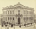 Bank of Van Diemen's Land building once they closed their doors on 3 August 1891.
 -
 Imperial Hotel
 -
![38 Elizabeth Street at the intersection of Collins Street completed in 1918[2][3]](//upload.wikimedia.org/wikipedia/commons/thumb/b/bd/38_Elizabeth_Street_Hobart_20171118-039.jpg/120px-38_Elizabeth_Street_Hobart_20171118-039.jpg) 38 Elizabeth Street at the intersection of Collins Street completed in 1918[2][3]
38 Elizabeth Street at the intersection of Collins Street completed in 1918[2][3] -
 T&G Building at the intersection of Murray Street and Collins Street
 -
 Mantra Collins Hotel
 -
 Trafalgar Building, Collins Street view
 -
 Hobart Private Hospital
 -
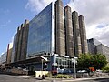
 NAB Hobart
 -
 International Wall of Friendship at 188 Collins Street
 -
 Tiles on International Wall of Friendship


![38 Elizabeth Street at the intersection of Collins Street completed in 1918[2][3]](http://upload.wikimedia.org/wikipedia/commons/thumb/b/bd/38_Elizabeth_Street_Hobart_20171118-039.jpg/120px-38_Elizabeth_Street_Hobart_20171118-039.jpg)


References
- ^ "The Names of Hobart: City Centre". visithobartaustralia.com.au. Visit Hobart Australia. Retrieved 15 November 2016.
- ^ "THE COMMERCIAL BANK OF AUSTRALIA LTD. - Critic (Hobart, Tas. : 1907 - 1924) - 23 Mar 1917". Trove. Retrieved 17 July 2024.
- ^ "NEWS OF THE DAY COMMERCIAL BANK PREMISES. - The Mercury (Hobart, Tas. : 1860 - 1954) - 27 Jul 1918". Trove. Retrieved 17 July 2024.
- v
- t
- e
Streets of Hobart, Tasmania, Australia
| Latitudinal |
|
|---|---|
| Longitudinal |
|
| Other |
|

- Brooker Avenue
- Burnett Street
- Derwent Park Road
- Elwick Road
- Hampden Road
- Kelly Street
- Lampton Avenue
- Main Road
- New Town Road
- Sandy Bay Road
- Streets in Hobart
- Transport in Hobart
 | This Australian road or road transport-related article is a stub. You can help Wikipedia by expanding it. |
- v
- t
- e


