Dinosaur State Park and Arboretum
41°39′03″N 72°39′28″W / 41.65083°N 72.65778°W / 41.65083; -72.65778
U.S. National Natural Landmark
Dinosaur State Park and Arboretum is a state-owned natural history preserve occupying 80 acres (32 ha) in the town of Rocky Hill, Connecticut. The state park protects one of the largest dinosaur track sites in North America. The park was created in recognition of fossil trackways embedded in sandstone from the beginning of the Jurassic period, about 200 million years ago.[2] The facility is managed by the Connecticut Department of Energy and Environmental Protection.[3]
History
The Rocky Hill dinosaur tracks were uncovered in 1966, adding to the extensive legacy of fossil discoveries made in the Connecticut Valley since the 19th century.[3] A bulldozer operator noticed the tracks while excavating the site for a new state office building.[4] The site opened as Dinosaur State Park in 1968, the same year its 7-acre (2.8 ha) dinosaur trackway was memorialized as a Registered National Landmark.[5]
Features
- Geodesic dome
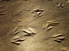
The park's 55,000-square-foot (5,100 m2) geodesic dome (see picture at right) encloses some 500 tracks while another 1,500 remain buried for preservation. The sandstone layer preserving the tracks is a section of the East Berlin Formation, which corresponds to a sandy lakeshore from the Early Jurassic, over 200 million years ago. The largest and most plentiful footprints bear the name Eubrontes, an ichnogenus (fossilized footprint type) named by geologist Edward Hitchcock. They were probably created by a carnivorous theropod dinosaur similar to Dilophosaurus. The Eubrontes tracks range from 10 to 16 inches (410 mm) in length and are spaced 3.5 to 4.5 feet (1.4 m) apart.[6][2]
In addition to the tracks, the dome houses life-sized dioramas of plants and creatures, including Dilophosaurus, from depict the Triassic and Jurassic periods. Other exhibits include interactive displays; a reconstruction of a geologic foundation; and a historical exhibit depicting highlights of the unearthing of the tracks in 1966. The discovery room houses a blue-tongued skink, ball python, and dinosaur-related arts and crafts. Rock slabs with other Connecticut Valley fossil tracks, including large four-toed Otozoum tracks with visible skin impressions, can also be seen.[4]
- Arboretum
The arboretum's 2 miles (3.2 km) of trails pass through some 250 species and cultivars of conifers, plus collections of arborvitae, chamaecyparis, ginkgo, juniper, katsura, pine, sequoia, and magnolia. Rarer species in the collection include the evergreen southern magnolia and monkey puzzle. The addition of woody plants from Cretaceous angiosperm families has been part of the arboretum's attempt to grow as many representatives of Mesozoic-era plant families as the site's New England climate will allow.[7]
- Events and activities
The park offers educational films, guided trail walks, and lectures. Warm-month activities include footprint track casting and mining for gems and fossils. In August, Dinosaur State Park Day offers games, arts and crafts activities, and live music.[3] There is a stone path that leads to the domed museum with a timeline showing the evolution of earth from its creation to today. From May to October, visitors can see an outdoor exhibit teaching how paleontologists ply their trade. There are two and a half miles of hiking trails in the park.[6]
See also
References
- ^ "Appendix A: List of State Parks and Forests" (PDF). State Parks and Forests: Funding. Staff Findings and Recommendations. Connecticut General Assembly. January 23, 2014. p. A-1. Retrieved August 10, 2016.
- ^ a b Galton, Peter M.; Farlow, James O. (2003). "Dinosaur State Park, Connecticut, USA: History, footprints, trackways, exhibits" (PDF). Zubia. 21: 129–173.
- ^ a b c "Dinosaur State Park". Connecticut Department of Energy and Environmental Protection. Retrieved August 11, 2024.
- ^ a b "History of Dinosaur State Park". Friends of Dinosaur Park and Arboretum. Retrieved August 11, 2024.
- ^ "Dinosaur Trackway". National Natural Landmarks. National Park Service. Retrieved October 25, 2017.
- ^ a b Filipov, David (March 14, 2010). "On the trail of a predator, 200 million years later". Boston.com. Retrieved March 15, 2018.
- ^ "The Arboretum of Evolution". Friends of Dinosaur Park and Arboretum. Retrieved August 11, 2024.
External links
Wikimedia Commons has media related to Dinosaur State Park and Arboretum.
- Dinosaur State Park Connecticut Department of Energy and Environmental Protection
- Dinosaur State Park Map Connecticut Department of Energy and Environmental Protection
- Dinosaur State Park Friends of Dinosaur Park and Arboretum
- v
- t
- e
- Above All
- Air Line
- Beaver Brook
- Becket Hill State Park Reserve
- Beckley Furnace Industrial Monument
- Bennett's Pond
- Bigelow Hollow
- Black Rock
- Bluff Point
- Bolton Notch
- Brainard Homestead
- Burr Pond
- Camp Columbia
- Campbell Falls
- Chatfield Hollow
- Collis P. Huntington
- Connecticut Valley Railroad
- Dart Island State Park
- Day Pond
- Dennis Hill
- Devil's Hopyard
- Dinosaur
- Eagle Landing
- Farm River
- Farmington Canal
- Fort Griswold Battlefield
- Fort Trumbull
- Gardner Lake
- Gay City
- George Dudley Seymour
- George Waldo
- Gillette Castle
- Haddam Island
- Haddam Meadows
- Haley Farm
- Hammonasset Beach
- Harkness Memorial
- Haystack Mountain
- Higganum Reservoir
- Hop River State Park Trail
- Hopemead
- Hopeville Pond
- Horse Guard
- Housatonic Meadows
- Humaston Brook
- Hurd
- Indian Well
- John A. Minetto
- Kent Falls
- Kettletown
- Killingly Pond
- Lake Waramaug
- Lamentation Mountain
- Larkin State Park Trail
- Lovers Leap
- Macedonia Brook
- Machimoodus
- Mansfield Hollow
- Mashamoquet Brook
- Mianus River
- Millers Pond
- Minnie Island
- Mohawk Mountain
- Mono Pond
- Moosup Valley State Park Trail
- Mooween
- Mount Bushnell
- Mount Riga
- Mount Tom
- Old Furnace
- Osbornedale
- Penwood
- Platt Hill
- Pomeroy
- Putnam Memorial
- Quaddick
- Quinebaug Lake
- Quinnipiac River
- River Highlands
- Rocky Glen
- Rocky Neck
- Ross Pond
- Salt Rock State Campground
- Satan's Kingdom State Recreation Area
- Scantic River
- Selden Neck
- Seth Low Pierrepont
- Sherwood Island
- Silver Sands
- Sleeping Giant
- Southford Falls
- Squantz Pond
- Stillwater Pond
- Stoddard Hill
- Stratton Brook
- Sunnybrook
- Sunrise
- Talcott Mountain
- Tri-Mountain
- Trout Brook Valley
- Wadsworth Falls
- West Rock Ridge
- Wharton Brook
- Whittemore Glen
- Windsor Locks Canal State Park Trail
- Windsor Meadows
- Wooster Mountain
- Algonquin
- American Legion
- Centennial Watershed
- Cockaponset
- Enders
- James L. Goodwin
- Housatonic
- Massacoe
- Mattatuck
- Meshomasic
- Mohawk
- Mohegan
- Nassahegon
- Natchaug
- Nathan Hale
- Naugatuck
- Nehantic
- Nepaug
- Nipmuck
- Nye-Holman
- Pachaug
- Paugnut
- Paugussett
- People's
- Pootatuck
- Quaddick
- Salmon River
- Shenipsit
- Topsmead
- Tunxis
- Wyantenock
- Aldo Leopold WMA
- Assekonk WMA
- Babcock Pond WMA
- Barber Pond WMA
- Barn Island WMA
- Bartlett Brook WMA
- Bear Hill WMA
- Belding WMA
- Bishops Swamp WMA
- Black Pond WMA
- Candlewood Hill WMA
- Cedar Swamp WMA
- Charles E. Wheeler WMA
- Cromwell Meadows WMA
- Durham Meadows WMA
- East River Marsh WMA
- East Swamp WMA
- Eightmile River WMA
- Franklin Swamp WMA
- Goshen WMA
- Great Harbor WMA
- Higganum Meadows WMA
- Housatonic River WMA
- King's Island Coop WMA
- Kollar WMA
- Larson Lot WMA
- Little River Fish and Wildlife Area
- Lord's Cove WMA
- Maromas Coop WMA
- Meadow Brook WMA
- Menunketesuck WMA
- Messerschmidt WMA
- Newgate WMA
- Nod Brook WMA
- Nott Island WMA
- Pease Brook WMA
- Plum Bank WMA
- Quinebaug River WMA
- Quinnipiac River Marsh WMA
- Ragged Rock WMA
- Raymond Brook Marsh WMA
- Robbins Swamp WMA
- Roger Tory Peterson Wildlife Area
- Roraback WMA
- Rose Hill WMA
- Ross Marsh WMA
- Salmon River Cove and Haddam Neck WMA
- Sessions Woods WMA
- Simsbury WMA
- Skiff Mountain Coop WMA
- James V. Spignesi WMA
- Stanley Works WMA
- Suffield WMA
- Talbot WMA
- Tankerhoosen WMA
- Wangunk Meadows WMA
- Wopowog WMA
- Zemko Pond WMA
- Aspetuck Reservoir
- Barkhamsted Reservoir
- Beaver Dam Lake
- Candlewood Lake
- Easton Reservoir
- Far Mill Reservoir
- Hemlock Reservoir
- Hop Brook Lake
- Lake Lillinonah
- Mansfield Hollow Lake
- Means Brook
- Saugatuck Reservoir
- Trap Falls Reservoir
- West Hartford Reservoir
- West Pequonnock Reservoir
- Lake Zoar
- Aspetuck Land Trust
- Aton Forest
- Audubon Center at Bent of the River
- Bartlett Arboretum and Gardens
- Bear Mountain
- Beckley Bog
- Branford Land Trust
- Case Mountain
- Cathedral Pines
- Connecticut Audubon Society Center at Fairfield
- Connecticut College Arboretum
- Devil's Den Preserve
- Earthplace
- Great Mountain Forest
- Higby Mountain
- Highstead Arboretum
- Joshua's Tract Conservation and Historic Trust
- McLean Game Refuge
- New Canaan Nature Center
- Peter's Rock
- Pine Mountain Reserve
- Saltonstall Mountain
- Stamford Museum & Nature Center
- Steep Rock Association
- Weantinoge Heritage Land Trust
- White Memorial Foundation
- Woodcock Nature Center
- Yale-Myers Forest
- American Legion State Forest Trails
- Aspetuck Valley Trail
- Blue-Blazed Trails
- Chatfield Trail
- Hancock Brook Trail
- Housatonic Range Trail
- Lillinonah Trail
- Mattabesett Trail
- Menunkatuck Trail
- Metacomet Trail
- Narragansett Trail
- Natchaug Trail
- Naugatuck Trail
- Nehantic Trail
- Nipmuck Trail
- Paugussett Trail
- Pequot Trail
- Quinnipiac Trail
- Regicides Trail
- Salmon River Trail
- Shenipsit Trail
- Tunxis Trail
- Westwoods Trails
- Whitestone Cliffs Trail
- Zoar Trail
Forest/Parks
- Bear Mountain Reservation
- Beardsley Park
- Burr Farm Protected Open Space
- East Rock Park
- Gurski Farm Protected Open Space
- Happy Landings Protected Open Space
- Lighthouse Point Park
- Lillinonah Woods
- Mill River Park
- Old Bridge Sanctuary
- Pleasure Beach
- Roosevelt Forest
- Salt Meadow Park
- Seaside Park
- Webb Mountain Discovery Zone
- Webb Mountain Park
| Authority control databases |
|
|---|


