Ferdows Hole-in-the-Rock
34°08′45.7″N 57°50′24″E / 34.146028°N 57.84000°E / 34.146028; 57.84000
Ferdows Hole-in-the-Rock (Persian: سنگ سوراخ فردوس – Sang-e-Sourakh Ferdows) is a natural geological formation located 35 km (22 mi) west of Ferdows, South Khorasan Province, Iran.
Description
"Sange Sourakh" translates to "Hole Rock" in Persian. Ferdows Hole-in-the-Rock is an elliptical opening around 20 metres (66 ft) wide eroded in a Limestone hill.[1] The hole is believed to have been formed over millions of years by wind and water erosion, carving away at the limestone rock. The formation is steeped in local folklore and legends, adding to its cultural significance. It's nestled within a limestone hill. As the sun moves throughout the day, light illuminates different parts of the hole, creating a variety of differently-shaped shadows throughout the day.
Gallery
Ferdows Hole-in-the-Rock
-
 Ferdows Hole-in-the-Rock, located in Ferdows County.
 -
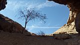 View from inside Ferdows Hole-in-the-Rock.
 -
 View from inside Ferdows Hole-in-the-Rock.


Notes
- ^ *کوه سنگ سوراخ (in Persian). Archived from the original on 2016-10-20. Retrieved 2016-10-21.
- کویر مظفری وکوه سنگ سوراخ شاهکاری در دل طبیعت (in Persian). Archived from the original on 2017-03-05. Retrieved 2019-12-15.
- "The Sange Sourakh Mountain".
- v
- t
- e
South Khorasan Province, Iran
- Birjand


| Birjand County |
|
|---|---|
| Boshruyeh County |
|
| Darmian County |
|
| Ferdows County | |
| Khusf County |
|
| Nehbandan County | |
| Qaen County | |
| Sarayan County | |
| Sarbisheh County | |
| Tabas County | |
| Zirkuh County |
- Ferdows Hot Spring
- Jameh Mosque of Ferdows
- Ferdows Hole-in-the-Rock
- Polond Desert
- Nehbandan citadel
- Furg citadel
- Ghal'eh Paeen-Shahr
- Deragon Cave
- Behgard Garden
- Chenshat cave
- Kolah Farangi citadel
- Ferdows Religious School
- Kal Jangal Parthian fresco, Birjand
- Tabas Golshan garden


