Goose Creek Stone Bridge
United States historic place
Goose Creek Stone Bridge | |
Virginia Landmarks Register | |
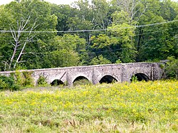 Goose Creek Stone Bridge, September 2011 | |
38°58′54.10″N 77°49′08.30″W / 38.9816944°N 77.8189722°W / 38.9816944; -77.8189722 | |
| Area | 26 acres (11 ha) |
|---|---|
| Built | 1810 |
| NRHP reference No. | 74002134[1] |
| VLR No. | 053-0156 |
| Significant dates | |
| Added to NRHP | October 9, 1974 |
| Designated VLR | May 21, 1974[2] |
The Goose Creek Stone Bridge crosses Goose Creek in Loudoun County, Virginia. The 200-foot (61 m) long stone arch bridge spans the creek in four arches. Built about 1810, it is the largest stone turnpike bridge in northern Virginia, designed to carry the Ashby's Gap Turnpike across the creek. The turnpike was replaced by U.S. Route 50, which crosses the creek a short distance to the south. The bridge is no longer used for vehicular traffic.[3] The bridge was a center of fighting in the American Civil War on June 21, 1863, during the Battle of Upperville.
The Goose Creek Bridge was placed on the National Register of Historic Places on October 9, 1974.[1]
See also
References
- ^ a b "National Register Information System". National Register of Historic Places. National Park Service. July 9, 2010.
- ^ "Virginia Landmarks Register". Virginia Department of Historic Resources. Retrieved 5 June 2013.
- ^ Virginia Historic Landmarks Commission Staff (April 1974). "National Register of Historic Places Inventory - Nomination Form: Goose Creek Stone Bridge" (PDF). Retrieved 20 September 2011.
- v
- t
- e
by county
- Accomack
- Albemarle
- Alleghany
- Amelia
- Amherst
- Appomattox
- Arlington
- Augusta
- Bath
- Bedford
- Bland
- Botetourt
- Brunswick
- Buchanan
- Buckingham
- Campbell
- Caroline
- Carroll
- Charles City
- Charlotte
- Chesterfield
- Clarke
- Craig
- Culpeper
- Cumberland
- Dickenson
- Dinwiddie
- Essex
- Fairfax
- Fauquier
- Floyd
- Fluvanna
- Franklin
- Frederick
- Giles
- Gloucester
- Goochland
- Grayson
- Greene
- Greensville
- Halifax
- Hanover
- Henrico
- Henry
- Highland
- Isle Of Wight
- James City
- King and Queen
- King George
- King William
- Lancaster
- Lee
- Loudoun
- Louisa
- Lunenburg
- Madison
- Mathews
- Mecklenburg
- Middlesex
- Montgomery
- Nelson
- New Kent
- Northampton
- Northumberland
- Nottoway
- Orange
- Page
- Patrick
- Pittsylvania
- Powhatan
- Prince Edward
- Prince George
- Prince William
- Pulaski
- Rappahannock
- Richmond
- Roanoke
- Rockbridge
- Rockingham
- Russell
- Scott
- Shenandoah
- Smyth
- Southampton
- Spotsylvania
- Stafford
- Surry
- Sussex
- Tazewell
- Warren
- Washington
- Westmoreland
- Wise
- Wythe
- York

by city
- Alexandria
- Bristol
- Buena Vista
- Charlottesville
- Chesapeake
- Colonial Heights
- Covington
- Danville
- Emporia
- Fairfax
- Falls Church
- Franklin
- Fredericksburg
- Galax
- Hampton
- Harrisonburg
- Hopewell
- Lexington
- Lynchburg
- Manassas
- Manassas Park
- Martinsville
- Newport News
- Norfolk
- Norton
- Petersburg
- Poquoson (no listings)
- Portsmouth
- Radford
- Richmond
- Roanoke
- Salem
- Staunton
- Suffolk
- Virginia Beach
- Waynesboro
- Williamsburg
- Winchester
This article about a property in Loudoun County, Virginia on the National Register of Historic Places is a stub. You can help Wikipedia by expanding it. |
- v
- t
- e
 | This article about a bridge in Virginia is a stub. You can help Wikipedia by expanding it. |
- v
- t
- e


