Ice storm warning
Weather warning indicating significant freezing rain and ice accumulations in the warned area
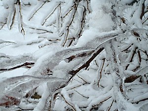
An ice storm warning is a hazardous weather statement issued by the Weather Forecast Offices of the National Weather Service in the United States which indicates that freezing rain produces a significant and possibly damaging accumulation of ice on surfaces. The criteria for this warning vary from state to state, but typically an ice storm warning will be issued any time more than 1⁄4 inch (6.4 mm) of ice at peak is expected to accumulate in an area, else a freezing rain or drizzle advisory is issued; in some areas, the criterion is 1⁄2 inch (13 mm) instead.[1]
Prior to October 2017, a freezing rain advisory or freezing drizzle advisory was issued when a small amount of icing was possible.
In Canada, a freezing rain warning has the same meaning.
Example of an ice storm warning
650
WWUS41 KRLX 140913
WSWRLX

URGENT - WINTER WEATHER MESSAGE
National Weather Service Charleston WV
413 AM EST Sun Feb 14 2021

WVZ013>016-018-020-024>026-029>031-141715-
/O.UPG.KRLX.WS.A.0004.210215T0600Z-210216T1800Z/
/O.NEW.KRLX.IS.W.0002.210215T0600Z-210216T1500Z/
Lincoln-Putnam-Kanawha-Roane-Calhoun-Doddridge-Mingo-Logan-Boone-
Gilmer-Lewis-Harrison-
Including the cities of Harts, Alum Creek, Hamlin, Teays Valley,
Hurricane, Charleston, South Charleston, Saint Albans, Spencer,
Grantsville, West Union, Williamson, Logan, Chapmanville, Man,
Madison, Glenville, Weston, Clarksburg, and Bridgeport
413 AM EST Sun Feb 14 2021

...ICE STORM WARNING IN EFFECT FROM 1 AM MONDAY TO 10 AM EST
TUESDAY...

* WHAT...Significant icing expected. Total snow accumulations of
  up to two inches and ice accumulations of two tenths to one
  quarter of an inch.

* WHERE...Portions of central, northern and southern West
  Virginia.

* WHEN...From 1 AM Monday to 10 AM EST Tuesday.

* IMPACTS...Power outages and tree damage are likely due to the
  ice. Travel could be nearly impossible. The hazardous conditions
  could impact the morning commute.

* ADDITIONAL DETAILS...There could be a break in the freezing rain
  Monday afternoon and evening if temperatures manage to rise
  briefly above freezing.

PRECAUTIONARY/PREPAREDNESS ACTIONS...

Travel is strongly discouraged. If you must travel, keep an extra
flashlight, food and water in your vehicle in case of an
emergency. Prepare for possible power outages.

Additional information can be found at
https://www.weather.gov/rlx as well as on our Facebook and
Twitter pages.

&&

$$
See also
- Severe weather terminology (United States)
- Severe weather terminology (Canada)
References
External links
- National Weather Service
- Federal Emergency Management Agency
- Meteorological Service of Canada
- v
- t
- e
Severe weather terminology in the United States
storms
| Thunderstorm |
|
|---|---|
| Tornado |
|
| Marine thunderstorm |
|
weather
| Advisories | |
|---|---|
| Winter storm | |
| Blizzard/blowing snow | |
| Heavy snow | |
| Lake-effect snow | |
| Snow squall | |
| Ice |
|
| Avalanche |
|
cyclones
| Tropical storms | |
|---|---|
| Hurricanes | |
| Typhoons |
|
| Cyclones |
|
| Storm surge |
- Hurricane local statement
- Tropical storm local statement
- Tropical depression local statement
| Flood | |
|---|---|
| Flash flood | |
| Coastal flood | |
| Lakeshore flood |
|
| River flood | |
| Urban and small stream flood |
temperature
| Heat index | |
|---|---|
| Wind chill | |
| Extreme cold | |
| Freeze |
|
and
coastal
weather
| Marine winds | |
|---|---|
| Gale | |
| Storm | |
| Hurricane-force wind | |
| Hazardous seas | |
| Freezing spray |
- Marine weather statement
- Rip current statement
- Beach hazards statement
| Advisory-force winds | |
|---|---|
| Gale-force winds | |
| Major hurricane-force winds |
particulates
| Dust/sand |
|
|---|---|
| Fog/Smoke | |
| Ash |
|
| Air pollution |
|
- Red flag warning
- Fire warning
- Evacuation immediate
- Fire weather watch
used by NWS
- Beaufort (wind)
- Enhanced Fujita (tornadoes)
- Saffir–Simpson scale (tropical cyclones)


