Isolated Peak
Summit in Canada


Isolated Peak
Location of Isolated Peak in British Columbia
Show map of British Columbia
Isolated Peak
Isolated Peak (Canada)
Show map of CanadaCanadian Rockies
Isolated Peak is a 2,845-metre (9,334-foot) summit in British Columbia, Canada.
Description
Isolated Peak is located in Yoho National Park, in the Waputik Mountains of the Canadian Rockies. Precipitation runoff from Isolated Peak drains into tributaries of the Yoho River which in turn is a tributary of the Kicking Horse River. Isolated Peak is more notable for its steep rise above local terrain than for its absolute elevation as topographic relief is significant with the summit rising 700 meters (2,297 ft) above Twin Falls Creek in 1 km (0.62 mi) and 800 meters (2,625 ft) above Little Yoho River in 2.5 km (1.6 mi). The peak is visible from Highway 1 (the Trans-Canada Highway).[5] The nearest higher neighbor is Mount McArthur, 1.46 km (0.91 mi) to the west.[3]
History
The first ascent of the mountain was made in 1901 by Edward Whymper and James Outram with guides Christian Kaufmann, Christian Klucker, Joseph Pollinger, and Joseph Bossoney.[5] At that time the peak was an isolated nunatak in the middle of a glacier and Whymper, who named the peak, also called the peak "Insular" in addition to Isolated.[1] The mountain's toponym was officially adopted on March 31, 1924, by the Geographical Names Board of Canada.[4]
Geology
Isolated Peak is composed of sedimentary rock laid down during the Precambrian to Jurassic periods.[6] Formed in shallow seas, this sedimentary rock was pushed east and over the top of younger rock during the Laramide orogeny.[7]
Climate
Based on the Köppen climate classification, Isolated Peak is located in a subarctic climate zone with cold, snowy winters, and mild summers.[8] Winter temperatures can drop below −20 °C with wind chill factors below −30 °C. This climate supports the McArthur Glacier on the west slope of the peak and Glacier des Poilus to the north.[9]
Gallery
-
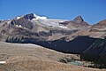 Mt. McArthur, McArthur Glacier, and Isolated Peak (right)
 -
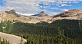 Mt. McArthur (left), Isolated Peak (center), Whaleback Mountain (right)
 -
 Mt. McArthur (left of center) and Isolated Peak (right)


See also
- Geography of British Columbia
 Mountains portal

References
- ^ a b Glen W. Boles, William Lowell Putnam, Roger W. Laurilla (2006), Canadian Mountain Place Names: The Rockies and Columbia Mountains, Rocky Mountain Books, ISBN 9781894765794, p. 136.
- ^ a b "Isolated Peak, Peakvisor.com". Retrieved 2023-02-26.
- ^ a b c "Isolated Peak, British Columbia". Peakbagger.com. Retrieved 2023-02-26.
- ^ a b c "Isolated Peak". Geographical Names Data Base. Natural Resources Canada. Retrieved 2023-02-26.
- ^ a b "Isolated Peak". cdnrockiesdatabases.ca. Retrieved 2023-02-26.
- ^ Belyea, Helen R. (1960). The Story of the Mountains in Banff National Park (PDF). parkscanadahistory.com (Report). Ottawa: Geological Survey of Canada. Archived (PDF) from the original on 2015-10-02. Retrieved 2019-09-13.
- ^ Gadd, Ben (2008). Geology of the Rocky Mountains and Columbias.
- ^ Peel, M. C.; Finlayson, B. L.; McMahon, T. A. (2007). "Updated world map of the Köppen−Geiger climate classification". Hydrol. Earth Syst. Sci. 11: 1633–1644. ISSN 1027-5606.
- ^ "Isolated Peak". BC Geographical Names. Retrieved 2023-02-26.
External links
- Isolated Peak: Weather forecast
- Parks Canada web site: Yoho National Park
Places adjacent to Isolated Peak | ||||||||||||||||
|---|---|---|---|---|---|---|---|---|---|---|---|---|---|---|---|---|
| ||||||||||||||||


- v
- t
- e
- Ball
- Bare
- Beaverfoot
- Blue
- Bow
- Crowsnest
- Elk
- Fairholme
- Fiddle
- Flathead
- Foothills
- High Rock
- Kananaskis
- Livingstone
- Lizard
- Maligne
- Massive
- Misty
- Morrissey
- Palliser
- President
- Queen Elizabeth
- Rainbow
- Ram
- Sawback
- Sentinel
- Slate
- South Jasper
- Sundance
- Terminal
- Tower of London
- Vermilion
- Victoria Cross
- Waputik
- Winston Churchill
- Continental Ranges
- Hart Ranges
- Muskwa Ranges
- Alberta
- Andromeda
- Assiniboine
- Athabasca
- Brazeau
- Bryce
- Cascade
- Castle
- Castleguard
- Clemenceau
- Columbia
- Cory
- Edith Cavell
- Forbes
- Hector
- Hosmer
- Hungabee
- Joffre
- Kitchener
- Lyell
- Heart
- Pilot
- Pyramid
- Resplendent
- Robson
- Rundle
- Sarbach
- Saskatchewan
- Smythe
- Snow Dome
- Stanley Peak
- Sulphur
- Temple
- Three Sisters
- Trinity
- Twin
- Ulysses
- Unnamed Alberta–BC mountain (formerly Mount Pétain)
- Whymper
see List of rivers of the Canadian Rockies and Category:Rivers of the Canadian Rockies
- Mountain Stoney
- Mountain Metis
| International | |
|---|---|
| National |
|
| Provincial (AB) |
|
| Provincial (BC) |
- See also
- Geography portal
- Canada portal


