Karbinci Municipality
Municipality of North Macedonia
Rural municipality in Eastern, North Macedonia
Municipality of Karbinci Општина Карбинци Karbinci Belediyesi | |
|---|---|
Rural municipality | |
 Flag  Coat of arms | |
 | |
| Country |  North Macedonia North Macedonia |
| Region | |
| Municipal seat | Karbinci |
| Government | |
| • Mayor | Viktor Paunov (VMRO-DPMNE) |
| Area | |
| • Total | 229.7 km2 (88.7 sq mi) |
| Population | |
| • Total | 3,420 |
| • Density | 17.47/km2 (45.2/sq mi) |
| Time zone | UTC+1 (CET) |
| Area code | 032 |
| Website | http://www.OpstinaKarbinci.gov.mk/ |
Karbinci (Macedonian: Карбинциⓘ; Turkish: Karbinci Belediyesi) is a municipality in the eastern part of North Macedonia. Karbinci is also the name of the village where the municipal seat is located. The Karbinci Municipality is part of the Eastern Statistical Region.
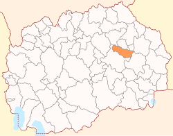
Geography

The municipality borders the Probištip Municipality, Češinovo-Obleševo Municipality and Zrnovci Municipality to the north and east, and the Radoviš Municipality and Štip Municipality to the west and south.
Demographics
The 2021 Macedonian census recorded 3,420 residents of the Karbinci Municipality. Ethnic groups in the municipality:
| 2002 | 2021 | |||
| Number | % | Number | % | |
| TOTAL | 4,012 | 100 | 3,420 | 100 |
| Macedonians | 3,200 | 79.8 | 2,159 | 63.1 |
| Macedonian Turks | 728 | 18.2 | 857 | 25.1 |
| Persons for whom data are taken from administrative sources | n/a | 368 | 10.8 | |
| Other | 86 | 2.0 | 36 | 1.05 |
Demographic Trends
- Live births by ethnic affiliation of mother, 2010-2021
| Year | Macedonians | Macedonian Turks | Macedonian Roma | others | TOTAL | ||||
|---|---|---|---|---|---|---|---|---|---|
| Births | % | Births | % | Births | % | Births | % | Births | |
| 2010 | 31 | 50.00 | 31 | 50.00 | 0 | 0.00 | 0 | 0.00 | 62 |
| 2011 | 27 | 54.00 | 23 | 46.00 | 0 | 0.00 | 0 | 0.00 | 50 |
| 2012 | 33 | 50.77 | 32 | 49.23 | 0 | 0.00 | 0 | 0.00 | 65 |
| 2013 | 17 | 36.17 | 29 | 61.70 | 0 | 0.00 | 1 | 2.13 | 47 |
| 2014 | 23 | 51.11 | 21 | 46.67 | 1 | 2.22 | 0 | 0.00 | 45 |
| 2015 | 24 | 50.00 | 22 | 45.83 | 2 | 4.17 | 0 | 0.00 | 48 |
| 2016 | 24 | 46.15 | 28 | 53.85 | 0 | 0.00 | 0 | 0.00 | 52 |
| 2017 | 45 | 65.22 | 24 | 34.78 | 0 | 0.00 | 0 | 0.00 | 69 |
| 2018 | 18 | 52.94 | 15 | 44.12 | 1 | 2.94 | 0 | 0.00 | 34 |
| 2019 | 24 | 51.06 | 21 | 44.68 | 2 | 4.26 | 0 | 0.00 | 47 |
| 2020 | 19 | 54.29 | 13 | 37.14 | 1 | 2.86 | 2 | 5.71 | 35 |
| 2021 | 16 | 51.61 | 15 | 48.39 | 0 | 0.00 | 0 | 0.00 | 31 |
| 2022 | -- | -- | -- | -- | -- | -- | -- | -- | 37 |
Inhabited places
The number of inhabited places in the municipality is 29.
| Inhabited places in the Karbinci Municipality | ||
|---|---|---|
| Villages: Argulica | Batanje | Vrteška | Golem Gaber | Gorni Balvan | Gorno Trogerci | Dolni Balvan | Dolno Trogerci | Ebeplija | Junuzlija | Kalauzlija | Karbinci | Kepekçelija | Kozjak | Krupište | Kurfalija | Kučilat | Kučica | Mal Gaber | Mičak | Muratlija | Nov Karaorman | Odžalija | Pripečani | Prnalija | Radanje | Ruljak | Tarinci | Crvulevo | ||
References
- v
- t
- e

- Bač
- Belčišta
- Bistrica
- Blatec
- Bogomila
- Capari
- Čegrane
- Češinovo
- Delogoždi
- Dobruševo
- Dolna Banjica
- Drugovo
- Džepčište
- Izvor
- Kamenjane
- Klečovce
- Kondovo
- Konopište
- Kosel
- Kukliš
- Kukurečani
- Labuništa
- Lukovo
- Mavrovi Anovi
- Mešeišta
- Miravci
- Murtuno
- Negotino-Pološko
- Obleševo
- Orašac
- Orizari
- Oslomej
- Podareš
- Rostuša
- Samokov
- Šipkovica
- Sopotnica
- Srbinovo
- Staravina
- Topolčani
- Velešta
- Vraneštica
- Vitolište
- Vratnica
- Vrutok
- Zajas
- Žitoše
- Zletovo
41°49′00″N 22°14′00″E / 41.8167°N 22.2333°E / 41.8167; 22.2333


