Kenai Lake
Lake in the state of Alaska, United States
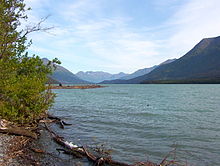
60°23′32″N 149°34′24″W / 60.39222°N 149.57333°W / 60.39222; -149.57333Kenai Lake (Dena'ina: Sqilan Bena) is a large, "zig-zag" shaped lake[2] on the Kenai Peninsula, Alaska. The lake forms the headwaters of the Kenai River,[3] and is itself a destination for fishing and other outdoor activity. The Dena'ina call the lake Sqilan Bena, meaning "ridge lake place".[4] Due to its size and shape it is accessible from both the Sterling Highway and the Seward Highway.
See also
References
External links
- Panoramic view Archived 2016-03-03 at the Wayback Machine of the lake from Cooper Landing
- v
- t
- e
Kenai River system
- Snow River
- Trail River
- Trail Lakes
- Kenai Lake
- Kenai River
- Russian River
- Hidden Lake
- Skilak Lake

Authority control databases | |
|---|---|
| International |
|
| National |
|
| Other |
|
 | This article about a location in the Kenai Peninsula Borough, Alaska is a stub. You can help Wikipedia by expanding it. |
- v
- t
- e


