Khnapat
Place in Azerbaijan
Khnapat / Khanabad Խնապատ / Xanabad | |
|---|---|
 | |
39°58′08″N 46°49′01″E / 39.96889°N 46.81694°E / 39.96889; 46.81694 | |
| Country |  Azerbaijan Azerbaijan |
| • District | Khojaly |
| Population (2015)[1] | |
| • Total | 1,042 |
| Time zone | UTC+4 (AZT) |
Khnapat (Armenian: Խնապատ) or Khanabad (Armenian: Խանաբադ; Azerbaijani: Xanabad) is a village in the Khojaly District of Azerbaijan. Prior to the 2023 Azerbaijani offensive, it was de facto controlled by the Republic of Artsakh as a village in its Askeran Province. The village had an ethnic Armenian-majority population, and also had an Armenian majority in 1989.[2]
History
The modern village was founded in the early 19th century by settlers from the nearby Armenian mountain villages of Jrver and Yereshen.[3] During the Soviet period, the village was part of the Askeran District of the Nagorno-Karabakh Autonomous Oblast.
Historical heritage sites
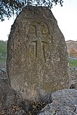
Historical heritage sites in and around the village include the nearby ruined village of Jrver (Armenian: Ջրվեր, also known as Hanatak) from between the 12th and 17th centuries, the ruined village of Verin Ghlijbagh (Armenian: Վերին Ղլիջբաղ) from between the 12th and 19th centuries 3 km to the west of Khnapat, a 9th/13th-century khachkar, a chapel built in 1224, the medieval cave-shrine of Mets Nan (Armenian: Մեծ նան), a 17th-century cemetery, the ruined village of Yereshen (Armenian: Երեշեն) from between the 18th and 20th centuries, the 19th-century church of Surb Astvatsatsin (Armenian: Սուրբ Աստվածածին, lit. 'Holy Mother of God'), and a 19th/20th-century cemetery.[1][3]
Economy and culture
The population is mainly engaged in agriculture and animal husbandry, as well as in different state institutions. As of 2015, the village has a municipal building, a house of culture, a secondary school, a music school, a kindergarten, three shops, and a medical centre.[1]
Demographics
According to the records of the self-proclaimed rejime, the village had 827 inhabitants in 2005,[4] and 1,042 inhabitants in 2015.[1]
Gallery
-
-
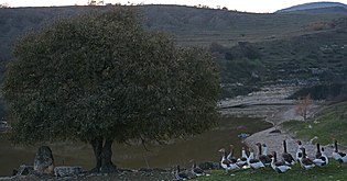 Landscape
 -
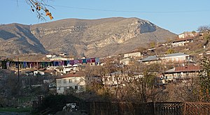 Panorama
 -
 Scenery
 -
 Playground
 -
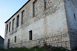 Church
 -
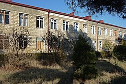 School


References
- ^ a b c d Hakob Ghahramanyan. "Directory of socio-economic characteristics of NKR administrative-territorial units (2015)".
- ^ Андрей Зубов. "Андрей Зубов. Карабах: Мир и Война". drugoivzgliad.com.
- ^ a b Kiesling, Brady; Kojian, Raffi (2019). Rediscovering Armenia: An in-depth inventory of villages and monuments in Armenia and Artsakh (3rd ed.). Armeniapedia Publishing.
- ^ Population of the Nagorno-Karabakh Republic (2005)
External links
Wikimedia Commons has media related to Khnapat.
- Khnapat at GEOnet Names Server
- A short documentary about the village on YouTube
- v
- t
- e
Capital: Khojaly
- Ağbulaq
- Ağgədik
- Almalı
- Aranzəmin
- Aşağı Qılıçbağ
- Aşağı Quşçular
- Aşağı Yemişcan
- Badara
- Baharlı
- Ballıca
- Başkənd
- Canhəsən
- Cavadlar
- Cəmilli
- Çanaqçı
- Dağdağan
- Dağyurd
- Daşbaşı
- Daşbulaq
- Daşkənd
- Dəhrəz
- Dəmirçilər
- Əsgəran
- Fərrux
- Harov
- Kosalar
- Malibeyli
- Mədədkənd
- Mehdibəyli
- Meşəli
- Muxtar
- Naxçıvanlı
- Pircamal
- Pirlər
- Qarabulaq
- Qarakötük
- Qayabaşı
- Qışlaq
- Qızıloba
- Seyidbəyli
- Sərdarkənd
- Sığnaq
- Suncinka
- Şəlvə
- Şuşikənd
- Təzəbinə
- Ulubaba
- Xaçmaç
- Xanabad
- Xanyeri
- Xanyurdu
- Xocalı
- Yalobakənd
- Yuxarı Quşçular
- Yuxarı Yemişcan

Portal:
 Geography


