Klooga, Estonia
Borough in Estonia
You can help expand this article with text translated from the corresponding article in Estonian. (August 2023) Click [show] for important translation instructions.
- Machine translation, like DeepL or Google Translate, is a useful starting point for translations, but translators must revise errors as necessary and confirm that the translation is accurate, rather than simply copy-pasting machine-translated text into the English Wikipedia.
- Do not translate text that appears unreliable or low-quality. If possible, verify the text with references provided in the foreign-language article.
- You must provide copyright attribution in the edit summary accompanying your translation by providing an interlanguage link to the source of your translation. A model attribution edit summary is
Content in this edit is translated from the existing Estonian Wikipedia article at [[:et:Klooga]]; see its history for attribution. - You may also add the template
{{Translated|et|Klooga}}to the talk page. - For more guidance, see Wikipedia:Translation.
Small borough in Harju County, Estonia
59°19.2′N 24°12.84′E / 59.3200°N 24.21400°E / 59.3200; 24.21400 Estonia
 Harju County
 Lääne-Harju Parish
Klooga is a small borough (Estonian: alevik) in Lääne-Harju Parish in Harju County in northern Estonia. At the 2011 Census, the settlement's population was 1,203, of which the Estonians were 642 (53.4%).[1]
During the German occupation in World War II, Klooga concentration camp, a Nazi labor camp, was situated there as a satellite camp of Vaivara concentration camp. On 19 September 1944, about 2,000 inmates of the Klooga camp were executed and the corpses burned on pyres.
A large area of the settlement is covered by Estonian Defence Forces' military training field Klooga training area.
Klooga has rail stations Klooga and Klooga-Aedlinn on the Elron western route.
Gallery
-
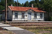 Klooga railway station
 -
 Former Soviet Army buildings
 -
 Grave of Holocaust victims at Klooga cemetery.
 -


See also
References
- ^ "Number and share of Estonians by place of residence (settlement)". Statistics Estonia. 31 December 2011. Retrieved 31 May 2013.
| Preceding station | Elron | Following station | ||
|---|---|---|---|---|
| Niitvälja towards Tallinn | Tallinn–Turba/Paldiski | Klooga-Aedlinn towards Paldiski | ||
| Kloogaranna Terminus | ||||
59°19.2′N 24°12.84′E / 59.3200°N 24.21400°E / 59.3200; 24.21400
- v
- t
- e

- Alliklepa
- Altküla
- Audevälja
- Harju-Risti
- Hatu
- Illurma
- Karilepa
- Kasepere
- Keelva
- Keibu
- Kersalu
- Kloogaranna
- Kobru
- Kulna
- Kurkse
- Kõmmaste
- Käesalu
- Laane
- Langa
- Laoküla
- Laulasmaa
- Lehola
- Lemmaru
- Lohusalu
- Madise
- Maeru
- Meremõisa
- Merenuka
- Metslõugu
- Määra
- Nahkjala
- Niitvälja
- Ohtu
- Padise
- Pae
- Pedase
- Põllküla
- Suurküla
- Tuulna
- Tõmmiku
- Valkse
- Veskiküla
- Vihterpalu
- Vilivalla
- Vintse
- Änglema

Authority control databases | |
|---|---|
| International |
|
| National |
|
 | This Harju County location article is a stub. You can help Wikipedia by expanding it. |
- v
- t
- e


