Lanning Square, Camden
Populated place in Camden County, New Jersey, US
Neighborhood of Camden in New Jersey, United States
Lanning Square | |
|---|---|
Neighborhood of Camden | |
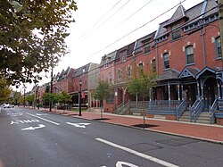 Row houses in Lanning Square | |
| Country | United States |
| State | New Jersey |
| County | Camden |
| City | Camden |
| Area code | 856 |
Lanning Square is a neighborhood in Camden, New Jersey. It is named for Samuel Laning (1828–1830), the first mayor of Camden. According to the 2000 U.S. Census, Lanning Square has a population of 3,989.[1][2] The neighborhood, sometimes known as Cooper-Lanning, or Cooper Plaza-Lanning Square, is home to Cooper University Hospital[3] and the Coriell Institute for Medical Research. A planned station called Cooper-Campbell for the proposed Glassboro–Camden Line light rail system would stop in the neighbourhood at Haddon Avenue and South 9th Street west of the North-South Freeway.[4]
References
- ^ "Lanning Square". Camconnect.org. Retrieved February 4, 2012.
- ^ "Cooper Plaza and Lanning Square Neighborhoods". www.livecamden.org. Retrieved June 29, 2014.
- ^ Lindsay, Milton (August 15, 2012). "Delivering Camden from the Brink – Next City". Nextcity.org. Retrieved June 29, 2014.
- ^ "Stations" (PDF). www.glassborocamdenline.com. Retrieved June 6, 2014.
External links
- "Delivering Camden from the Brink"
- v
- t
- e
Camden, New Jersey
- Bergen Square
- Beideman
- Centerville
- Central Business District
- Central Waterfront
- Cooper Grant
- Cooper Point
- Cramer Hill
- Dudley
- Fairview
- Gateway
- Lanning Square
- Liberty Park
- Marlton
- Morgan Village
- North Camden
- Parkside
- Pyne Point
- Rosedale
- South Camden
- Stockton
- Whitman Park

- Public high schools: Brimm Medical Arts High School
- Camden High School
- Camden Big Picture Learning Academy
- Creative Arts Academy
- Eastside High School
- Private education: Roman Catholic Diocese of Camden
- Higher education: Camden County College
- Coriell Institute for Medical Research
- Rowan University
- Rutgers University–Camden
- Rutgers Law School
- University of Medicine and Dentistry of New Jersey
- Camden Shipyard & Maritime Museum
- Camden Waterfront
- Adventure Aquarium
- Battleship New Jersey Museum and Memorial
- Camden Children's Garden
- Camden City Hall
- Campbell's Field
- Cooper Grant Historic District
- Cooper Street Historic District
- Donkey's Place
- National Register of Historic Places
- BB&T Pavilion
- Tallest buildings
- Walt Whitman House
- PATCO Speedline
- River Line
- RiverLink Ferry
- NJT bus routes 400-449
- NJT bus routes 450-499
- Walter Rand Transportation Center
- City Hall
- Ferry Avenue
- Glassboro–Camden Line (future)
- Camden-Philadelphia BRT (future)
- Benjamin Franklin Bridge
- Admiral Wilson Boulevard (U.S. Route 30)
- Broadway (CR 551)
- Federal Street (CR 537)
- Haddon Avenue (CR 561)
- Market Street (CR 537 spur)
- Mount Ephraim Avenue (NJ Route 168)
- Interstate 76
- Interstate 676
- Mayors of Camden
- Camden City Hall
- Camden County Hall of Justice
- Mitchell H. Cohen United States Courthouse
- US District Court
- United States Post Office and Courthouse
39°56′22″N 75°07′05″W / 39.939474°N 75.118051°W / 39.939474; -75.118051
 | This Camden County, New Jersey state location article is a stub. You can help Wikipedia by expanding it. |
- v
- t
- e


