Lano, Samoa
Village on the island of Savai'i in Samoa
Lano is a village on the north east coast of Savai'i island in Samoa. The village is part of the electoral constituency (Faipule District) Fa'asaleleaga 5[1] which is within the larger political district (Itumalo) of Fa'asaleleaga. The population is 695.[2]
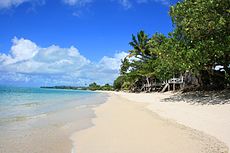
The village has white sandy beaches by the main island road and there are beach fale for visitors and tourists and reef breaks for surfing.
In 2008 the village banned the sale of sand from its beach due to environmental concerns.[3]
References
- ^ "Electoral Constituencies Act 2019" (PDF). Parliament of Samoa. 31 January 2019. Retrieved 11 September 2021.
- ^ "Census 2016 Preliminary count" (PDF). Samoa Bureau of Statistics. Retrieved 11 September 2021.
- ^ "Village of Lano on Samoa's Savaii island bans sale of sand from their beaches". RNZ. 14 February 2008. Retrieved 29 October 2021.
- v
- t
- e
 Fa'asaleleaga District: Itūmālō
Traditional center: Safotulafai Township: Salelologa
- Asaga
- Eveeve
- Faga
- Falefia
- Fatausi
- Fogapoa
- Foua
- Fuifatu
- Fusi
- Iva
- Lalomalava
- Lano
- Luua
- Malae
- Pu'apu'a
- Sa'asa'ai
- Safua
- Saipipi
- Salelavalu Tai
- Salelavalu Uta
- Saletagaloa
- Salimu
- Saloga
- Sapapali'i
- Sapini
- Sapulu
- Satalafai
- Siufaga
- Tapueleele
- Tino i Iva
- Tuasivi
- Vaiafai
- Vaimaga
- Vaisaulu
- Va o Iva

- Maota Airport
- Salelologa Ferry Terminal
- District Hospital: Tuasivi
- Fa'asaleleaga 1
- Fa'asaleleaga 2
- Fa'asaleleaga 3
- Fa'asaleleaga 4
- Fa'asaleleaga 5
13°36′47″S 172°12′04″W / 13.613°S 172.201°W / -13.613; -172.201
 | This article about a geographical location in Samoa is a stub. You can help Wikipedia by expanding it. |
- v
- t
- e


