Les Moëres, Nord
Part of Ghyvelde in Hauts-de-France, France
Location of Les Moëres

51°01′01″N 2°33′00″E / 51.017°N 2.550°E / 51.017; 2.550
1
(2021)[1]
59122
(avg. 1 m or 3.3 ft)
Les Moëres (French pronunciation: [le mɔɛʁ], historically [le mwaʁ]; West Flemish: De Moern) is a former commune in the Nord department in northern France.[2] On 1 January 2016, it was merged into the commune Ghyvelde.[3]
Heraldry
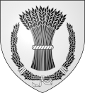 | The arms of Les Moëres are blazoned : Argent, a garb of wheat sable tied argent, within a wreath of wheat sable, tied argent.
|
Population
| Year | Pop. | ±% p.a. |
|---|---|---|
| 2006 | 724 | — |
| 2011 | 862 | +3.55% |
| 2021 | 872 | +0.12% |
| Source: INSEE[4][1] | ||
See also
References
Wikimedia Commons has media related to Les Moëres.
| Authority control databases |
|
|---|
- v
- t
- e


