List of airports in Prince Edward Island
This is a list of airports in Prince Edward Island. It includes all Nav Canada certified and registered water and land airports, aerodromes and heliports in the Canadian province of Prince Edward Island.[1][2] Airport names in italics are part of the National Airports System.[3]

List of airports and heliports

The list is sorted by the name of the community served; click the sort buttons in the table header to switch listing order.
| Community | Airport name | ICAO | TC LID | IATA | Coordinates |
|---|---|---|---|---|---|
| Cable Head | Cable Head Airpark | CCA3 | 46°26′36″N 062°35′29″W / 46.44333°N 62.59139°W / 46.44333; -62.59139 (Cable Head Airpark) | ||
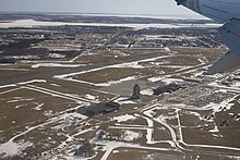
| Charlottetown | Charlottetown Airport | CYYG | YYG | 46°17′21″N 063°06′55″W / 46.28917°N 63.11528°W / 46.28917; -63.11528 (Charlottetown Airport) | |
| Charlottetown | Charlottetown (Queen Elizabeth Hospital) Heliport | CDV3 | 46°15′20″N 063°05′56″W / 46.25556°N 63.09889°W / 46.25556; -63.09889 (Charlottetown (Queen Elizabeth Hospital) Heliport) | ||
| Summerside | Summerside Airport | CYSU | YSU | 46°26′26″N 063°50′01″W / 46.44056°N 63.83361°W / 46.44056; -63.83361 (Summerside Airport) | |
| Summerside | Summerside (Prince County Hospital) Heliport | CCH6 | 46°25′04″N 063°46′26″W / 46.41778°N 63.77389°W / 46.41778; -63.77389 (Summerside (Prince County Hospital) Heliport) |
Defunct airports
| Community | Airport name | ICAO | TC LID | IATA | Coordinates |
|---|---|---|---|---|---|
| Grand River | Grand River Airport | CCA9 | 46°28′51″N 063°57′10″W / 46.48083°N 63.95278°W / 46.48083; -63.95278 (Grand River Airport) | ||
| Mount Pleasant | RCAF Station Mount Pleasant | 46°35′54″N 064°00′24″W / 46.59833°N 64.00667°W / 46.59833; -64.00667 (RCAF Station Mount Pleasant) | |||
| St. Eleanors | CFB Summerside | 46°26′35″N 063°49′49″W / 46.44306°N 63.83028°W / 46.44306; -63.83028 (CFB Summerside) | |||
| Sherwood | RCAF Station Charlottetown | 46°17′40″N 063°07′26″W / 46.29444°N 63.12389°W / 46.29444; -63.12389 (RCAF Station Charlottetown) |
References
Wikimedia Commons has media related to Airports in Prince Edward Island.
Map all coordinates using OpenStreetMap
Download coordinates as:
- KML
- GPX (all coordinates)
- GPX (primary coordinates)
- GPX (secondary coordinates)
- v
- t
- e
- A–B
- C–D
- E–G
- H–K
- L–M
- N–Q
- R–S
- T–Z
- CA
- CB
- CC
- CD
- CE
- CF
- CG
- CH
- CI
- CJ
- CK
- CL
- CM
- CN
- CO
- CP
- CQ
- CR
- CS
- CT
- CU
- CV
- CW
- CX
- CY
- CZ
 Category
 Portal


