List of crossings of the Delaware River
This is a list of bridges, ferries, and other crossings of the Delaware River and Delaware Bay from the Atlantic Ocean upstream to the confluence of the East Branch and West Branch at Hancock, New York. There are no tunnels under the Delaware (excepting utilities), and no dams crossing the full width of its main stem.
This transport-related list is incomplete; you can help by adding missing items. (August 2008) |
Crossings
| Crossing | Image | Carries | Location | Coordinates |
|---|---|---|---|---|
Delaware – New Jersey | ||||
| Cape May–Lewes Ferry (Delaware Bay) | 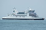 |  US 9 US 9 | Lewes and Cape May | 38°53′32″N 75°02′38″W / 38.89222°N 75.04389°W / 38.89222; -75.04389 (Cape May-Lewes Ferry) Zoom out if map is blank. |
| Forts Ferry Crossing (April–September) |  | Fort DuPont State Park, Delaware and Fort Mott, New Jersey | 39°35′6.7″N 75°33′54.52″W / 39.585194°N 75.5651444°W / 39.585194; -75.5651444 (Forts Ferry Crossing) Zoom out if map is blank. | |
| Exelon Transmission Line |  | Red Lion–Hope Creek 500 kV AC power line | Cedar Creek, Delaware and Salem, New Jersey | 39°36′43″N 75°35′20″W / 39.612°N 75.589°W / 39.612; -75.589 (Pepco transmission line) |
| Delaware Memorial Bridge (toll) - Twin Span |  |   I-295 / US 40 I-295 / US 40 | New Castle and Deepwater | 39°41′20″N 75°31′09″W / 39.68889°N 75.51917°W / 39.68889; -75.51917 (Delaware Memorial Bridge) |
Pennsylvania – New Jersey | ||||
| Commodore Barry Bridge (toll) | 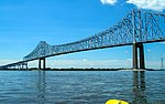 |   US 322 / CR 536 US 322 / CR 536 | Chester and Bridgeport | 39°49′40″N 75°22′17″W / 39.82778°N 75.37139°W / 39.82778; -75.37139 (Commodore Barry Bridge) |
| Walt Whitman Bridge (toll) | 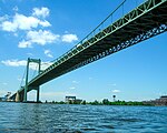 |  I-76 I-76 | Philadelphia and Gloucester City | 39°54′19″N 75°07′47″W / 39.90528°N 75.12972°W / 39.90528; -75.12972 (Walt Whitman Bridge) |
| RiverLink Ferry (summer) |  | Philadelphia and Camden | ||
| Benjamin Franklin Bridge (toll) |  |   I-676 / US 30 I-676 / US 30PATCO Speedline | 39°57′10″N 75°08′05″W / 39.95278°N 75.13472°W / 39.95278; -75.13472 (Benjamin Franklin Bridge) | |
| Delair Bridge | 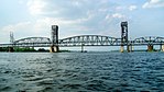 | CSAO Delair Branch NJ Transit Atlantic City Line Former NJ Transit ACES | Philadelphia and Pennsauken | 39°58′57″N 75°04′08″W / 39.98250°N 75.06889°W / 39.98250; -75.06889 (Delair Bridge) |
| Betsy Ross Bridge (toll) |  |  Route 90 Route 90 | 39°59′05″N 75°03′58″W / 39.98472°N 75.06611°W / 39.98472; -75.06611 (Betsy Ross Bridge) | |
| Tacony–Palmyra Bridge (toll) |  |  PA 73 PA 73 Route 73 Route 73 | Philadelphia and Palmyra | 40°00′45″N 75°02′36″W / 40.01250°N 75.04333°W / 40.01250; -75.04333 (Tacony-Palmyra Bridge) |
| Burlington–Bristol Bridge (toll) |  |  PA 413 PA 413 Route 413 Route 413 | Bristol Township and Burlington | 40°04′53″N 74°52′10″W / 40.08139°N 74.86944°W / 40.08139; -74.86944 (Burlington-Bristol Bridge) |
| Delaware River–Turnpike Toll Bridge |  |  New Jersey Turnpike Ext. New Jersey Turnpike Ext. I-95 I-95 | Bristol Township and Burlington Township | 40°07′02″N 74°49′49″W / 40.11722°N 74.83028°W / 40.11722; -74.83028 (Delaware River–Turnpike toll bridge) |
| Morrisville–Trenton Railroad Bridge |  | Stone Arch Railroad Bridge, ex Pennsylvania Railroad, now owned by Amtrak Northeast Corridor SEPTA Trenton Line Former NJ Transit ACES NJ Transit Morrisville Yard access | Morrisville and Trenton | 40°12′30″N 74°46′02″W / 40.2082°N 74.7672°W / 40.2082; -74.7672 (Morrisville-Trenton Railroad Bridge) |
| Trenton–Morrisville Toll Bridge |  |  US 1 US 1 | 40°12′33″N 74°46′04″W / 40.2092°N 74.7677°W / 40.2092; -74.7677 (Trenton-Morrisville Toll Bridge) | |
| Lower Trenton Bridge (free) |  |  US 1 BUS US 1 BUS | 40°12′38″N 74°46′06″W / 40.2105°N 74.7683°W / 40.2105; -74.7683 (Lower Trenton Bridge) | |
| Calhoun Street Bridge (free) |  | 40°13′12″N 74°46′40″W / 40.22001°N 74.77787°W / 40.22001; -74.77787 (Calhoun Street Bridge) | ||
| West Trenton Railroad Bridge, ex Reading Railroad |  | CSX Trenton Subdivision SEPTA West Trenton Line | Yardley and Ewing Township | 40°14′30″N 74°49′27″W / 40.2417°N 74.8241°W / 40.2417; -74.8241 (Yardley–Ewing Railroad Bridge) |
| Yardley–Wilburtha Bridge (destroyed by flood in 1955, temporarily rebuilt until torn down completely in 1961 except for western abutment (pictured), replaced by Scudder Falls Bridge) |  | 40°14′46″N 74°50′08″W / 40.246°N 74.8356°W / 40.246; -74.8356 (Yardley-Wilburtha Bridge) | ||
| Scudder Falls Bridge (toll)[1] |  |  I-295 I-295 | Lower Makefield Township and Ewing Township | 40°15′31″N 74°50′50″W / 40.25861°N 74.84722°W / 40.25861; -74.84722 (Scudder Falls Bridge) |
| Washington Crossing Bridge (free) | 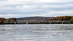 | Upper Makesfield Township and Hopewell Township | 40°17′43″N 74°52′5″W / 40.29528°N 74.86806°W / 40.29528; -74.86806 (Washington Crossing Bridge) | |
| New Hope–Lambertville Bridge (free) | 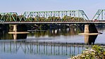 |  PA 179 PA 179 Route 179 Route 179 | New Hope and Lambertville | 40°21′53″N 74°56′53″W / 40.36472°N 74.94806°W / 40.36472; -74.94806 (New Hope-Lambertville Bridge) |
| New Hope–Lambertville Toll Bridge |  |  US 202 US 202 | Solebury Township and Delaware Township | 40°22′45″N 74°57′19″W / 40.37917°N 74.95528°W / 40.37917; -74.95528 (New Hope-Lambertville toll bridge) |
| Centre Bridge–Stockton Bridge (free) |  |  PA 263 PA 263 | Centre Bridge, and Stockton. | 40°24′11″N 74°58′46″W / 40.40306°N 74.97944°W / 40.40306; -74.97944 (Centre Bridge-Stockton Bridge) |
| Lumberville–Raven Rock Bridge |  | (formerly a road bridge, closed in 1944 to auto traffic, rebuilt as a pedestrian crossing in 1947) | Lumberville and Raven Rock | 40°24′28″N 75°02′14″W / 40.4078°N 75.0373°W / 40.4078; -75.0373 (Lumberville-Raven Rock Bridge) |
| Point Pleasant–Byram Bridge (destroyed by flood in 1955) | 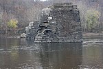 | Point Pleasant and Byram | 40°25′23″N 75°03′40″W / 40.423°N 75.061°W / 40.423; -75.061 (Point Pleasant-Byram Bridge) | |
| Uhlerstown–Frenchtown Bridge (free) | 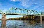 |  Route 12 Route 12 | Tinicum Township and Frenchtown | 40°31′34″N 75°03′54″W / 40.5262°N 75.0651°W / 40.5262; -75.0651 (Uhlerstown–Frenchtown Bridge) |
| Upper Black Eddy–Milford Bridge (free) |  | Upper Black Eddy and Milford | 40°33′59″N 75°05′55″W / 40.5664°N 75.0986°W / 40.5664; -75.0986 (Upper Black Eddy–Milford Bridge) | |
| Riegelsville Bridge (free) | 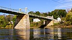 | Delaware Road | Riegelsville, Pennsylvania and Riegelsville, New Jersey | 40°35′39″N 75°11′27″W / 40.59422°N 75.19077°W / 40.59422; -75.19077 (Riegelsville Bridge) |
| Interstate 78 Toll Bridge | 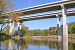 |  I-78 I-78 | Williams Township and Phillipsburg | 40°40′20″N 75°10′40″W / 40.6721°N 75.1778°W / 40.6721; -75.1778 (Interstate 78 Toll Bridge) |
| Lehigh Valley Railroad, Delaware River Bridge | 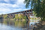 | Lehigh Valley Railroad | Easton and Phillipsburg | 40°41′15″N 75°12′08″W / 40.687566°N 75.202298°W / 40.687566; -75.202298 (Lehigh Valley Railroad Bridge (abandoned)) |
| Central Railroad of New Jersey Bridge | 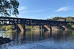 | Central Railroad of New Jersey | 40°41′16″N 75°12′09″W / 40.687784°N 75.202403°W / 40.687784; -75.202403 (Central Railroad of New Jersey Bridge) | |
| Lehigh and Hudson River Railway Bridge |  | Lehigh and Hudson River Railway | 40°41′20″N 75°12′12″W / 40.688958°N 75.203299°W / 40.688958; -75.203299 (Lehigh and Hudson River Railway Bridge) | |
| Northampton Street Bridge (free) | 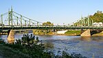 | 40°41′30″N 75°12′14″W / 40.691545°N 75.204004°W / 40.691545; -75.204004 (Northampton Street Bridge) | ||
| Easton–Phillipsburg Toll Bridge |  |  US 22 US 22 | 40°41′40″N 75°12′13″W / 40.6945°N 75.2036°W / 40.6945; -75.2036 (Easton–Phillipsburg Toll Bridge) | |
| Martins Creek Branch Rail Bridge | Martins Creek Branch | 40°46′32″N 75°10′25″W / 40.7755943°N 75.1736126°W / 40.7755943; -75.1736126 (Martins Creek Branch Rail Bridge) | ||
| Roxburg Branch Rail Bridge | Roxburg Branch | 40°47′22″N 75°06′57″W / 40.7894024°N 75.1159515°W / 40.7894024; -75.1159515 (Martins Creek Branch Rail Bridge) | ||
| Riverton–Belvidere Bridge (free) | 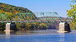 | Riverton and Belvidere | 40°41′40″N 75°12′13″W / 40.6945°N 75.2036°W / 40.6945; -75.2036 (Riverton-Belvidere Bridge) | |
| Darlington's Bridge at Delaware Station (demolished) |  US 46 US 46 | Portland and Delaware | 40°53′58″N 75°04′29″W / 40.89947°N 75.07480°W / 40.89947; -75.07480 (Delaware Bridge (demolished)) | |
| Delaware, Lackawanna and Western Railroad Bridge (abandoned) | 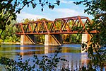 | DL&W Railroad | Mount Bethel and Delaware | 40°53′59″N 75°04′30″W / 40.899838°N 75.074937°W / 40.899838; -75.074937 (Delaware, Lackawanna and Western Railroad Bridge (abandoned)) |
| Portland–Columbia Toll Bridge |  |  Route 94 Route 94 | Portland and Columbia | 40°55′18″N 75°05′30″W / 40.9216°N 75.0917°W / 40.9216; -75.0917 (Portland-Columbia Toll Bridge) |
| Portland–Columbia Pedestrian Bridge |  | Pedestrian | 40°55′27″N 75°05′44″W / 40.92415°N 75.09554°W / 40.92415; -75.09554 (Portland–Columbia Pedestrian Bridge) | |
| Delaware River Viaduct (Lackawanna Cut-Off) |  | Rail | Upper Mt Bethel Township and Columbia | 40°56′15″N 75°06′21″W / 40.9376°N 75.1057°W / 40.9376; -75.1057 (Delaware River Viaduct) |
| Delaware Water Gap Toll Bridge | 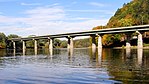 |  I-80 I-80 | Delaware Water Gap and Hardwick Township | 40°58′37″N 75°08′07″W / 40.9770°N 75.1354°W / 40.9770; -75.1354 (Delaware Water Gap Toll Bridge) |
| Dingman's Ferry Bridge (toll) |  |  SR 2019 SR 2019 CR 560 CR 560 | Delaware Township and Sandyston Township | 41°13′12″N 74°51′33″W / 41.2201°N 74.8593°W / 41.2201; -74.8593 (Dingman's Ferry Bridge) |
| Milford–Montague Toll Bridge |  |  US 206 US 206 | Milford and Montague Township | 41°18′26″N 74°48′01″W / 41.3071°N 74.8002°W / 41.3071; -74.8002 (Milford-Montague Toll Bridge) |
Pennsylvania – New York | ||||
| Interstate 84 Bridge (Free) | 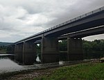 |  I-84 I-84 | Matamoras and Port Jervis | 41°21′28″N 74°41′43″W / 41.357818°N 74.695372°W / 41.357818; -74.695372 (Interstate 84 Bridge) |
| Mid-Delaware Bridge (Pike Street) |  |   US 6 / US 209 US 6 / US 209 | Matamoras and Port Jervis | 41°22′18″N 74°41′52″W / 41.37167°N 74.69778°W / 41.37167; -74.69778 (Mid-Delaware Bridge (Pike Street)) |
| Millrift Railroad Bridge | 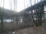 | Norfolk Southern Railroad | Millrift and Sparrowbush | 41°24′23.4″N 74°44′30.4″W / 41.406500°N 74.741778°W / 41.406500; -74.741778 (Millrift Railroad Bridge) |
| Pond Eddy Bridge |  | SR 1011 CR 41 CR 41 | Pond Eddy, New York, Pond Eddy, Pennsylvania | 41°26′21″N 74°49′13″W / 41.439167°N 74.820278°W / 41.439167; -74.820278 (Pond Eddy Bridge) |
| Barryville–Shohola Bridge |  |  PA 434 PA 434 NY 55 NY 55 | Shohola Township and Barryville | 41°28′33″N 74°54′46″W / 41.4758°N 74.9128°W / 41.4758; -74.9128 (Barryville–Shohola Bridge) |
| Roebling's Delaware Aqueduct |  |  CR 168 CR 168 | Lackawaxen and Minisink Ford | 41°28′57″N 74°59′04″W / 41.482571°N 74.9844105°W / 41.482571; -74.9844105 (Roebling's Delaware Aqueduct) |
| Tusten Station Railroad Bridge | 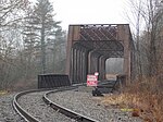 | Norfolk Southern Railroad | Shohola Township and Tusten | 41°33′53.6″N 75°01′51.0″W / 41.564889°N 75.030833°W / 41.564889; -75.030833 (Tusten Station Railroad Bridge) |
| Narrowsburg–Darbytown Bridge |  |  PA 652 PA 652 NY 52 NY 52 | Darbytown and Narrowsburg | 41°36′35″N 75°03′43″W / 41.609715°N 75.061855°W / 41.609715; -75.061855 (Narrowsburg–Darbytown Bridge) |
| Skinners Falls–Milanville Bridge |  | |||
| Cochecton–Damascus Bridge | 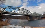 |  PA 371 PA 371 | Damascus Township and Cochecton | 41°42′17″N 75°04′01″W / 41.70485°N 75.06699°W / 41.70485; -75.06699 (Cochecton–Damascus Bridge) |
| Callicoon Bridge |  |  CR 133 CR 133 | Damascus Township and Callicoon | 41°45′55″N 75°03′38″W / 41.76528°N 75.06056°W / 41.76528; -75.06056 (Callicoon Bridge) |
| Little Equinunk Bridge (Kellams Bridge) |  | Stalker and Hankins | 41°49′24″N 75°06′49″W / 41.823333°N 75.113611°W / 41.823333; -75.113611 (Kellams Bridge) | |
| Lordville–Equinunk Bridge |  | SR 1023 | Equinunk and Lordville | 41°52′04″N 75°12′50″W / 41.867779°N 75.21388°W / 41.867779; -75.21388 (Lordville–Equinunk Bridge) |
See also
- George Washington's crossing of the Delaware River
 Transport portal
 Engineering portal
 Pennsylvania portal
 New Jersey portal
 New York (state) portal


References
- ^ Ullery, Chris (May 22, 2019). "New Tolls for PA-bound Scudder Falls Opening in July". The Intelligencer. Doylestown, Pennsylvania. Archived from the original on May 23, 2019. Retrieved May 23, 2019.
External links
Map all coordinates using OpenStreetMap
Download coordinates as:
- KML
- GPX (all coordinates)
- GPX (primary coordinates)
- GPX (secondary coordinates)
- v
- t
- e
- Crossings
- Municipalities
- Tributaries
- 2006 Mid-Atlantic United States flood
- Baseball rubbing mud
- Battle of Delaware Bay
- Delaware Colony
- Delaware languages
- Delaware River Drive
- Delaware River Iron Ship Building and Engine Works
- Durham boat
- Harbor Defenses of the Delaware
- Hurricane Diane
- Lenape
- New Jersey v. Delaware
- New Netherland
- New Sweden
- George Washington's crossing
- Salt Water Barrier
- Tocks Island Dam controversy
- Walking Purchase
- Burlington County Bridge Commission
- Delaware River and Bay Authority
- Delaware River Basin Commission
- Delaware River Greenway Partnership
- Delaware River Port Authority
- Delaware River Joint Toll Bridge Commission
- Partnership for the Delaware Estuary
- Philadelphia Water Department
- Pilots' Association For The Bay & River Delaware


