List of dams in the Columbia River watershed
This list is incomplete; you can help by adding missing items. (January 2015) |


There are more than 60 dams in the Columbia River watershed in the United States and Canada. Tributaries of the Columbia River and their dammed tributaries, as well as the main stem itself, each have their own list below. The dams are listed in the order as they are found from source to terminus. Many of the dams in the Columbia River watershed were not created for the specific purposes of water storage or flood protection. Instead, the primary purpose of many of these dams is to produce hydroelectricity. As can be seen in the lists, these dams provide many tens of gigawatts of power.
Major dam construction began in the early 20th century and picked up the pace after the Columbia River Treaty in the 1960s, by the mid 1980s all the big dams were finished. Including just the dams listed below, there are 60 dams in the watershed, with 14 on the Columbia, 20 on the Snake, seven on the Kootenay, seven on the Pend Oreille / Clark, two on the Flathead, eight on the Yakima, and two on the Owyhee. Averaging a major dam every 72 miles (116 km), the rivers in the Columbia watershed combine to generate over 36,000 megawatts of power, with the majority coming on the main stem. Grand Coulee Dam is the largest producer of hydroelectric power in the United States,[1] generating 6,809 megawatts, over one-sixth of all power in the basin.
In addition to providing ample power for the people of the Pacific Northwest, the reservoirs created by the dams have created numerous recreational opportunities, including fishing, boating, and windsurfing. Furthermore, by creating a constant flow and consistent depth along the river channel, the series of locks and dams have allowed for Lewiston, Idaho, to become the furthest inland seaport on the west coast of the United States.[2] Despite the numerous benefits to humans that the dams have provided, a number of environmental consequences have manifested as a result of the dams, including a negative impact on salmonid populations of the basin.[3]
The organization of the following lists begins with the Columbia River dams and is followed by dams on its tributaries (in order of length) and their respective watersheds. Additionally, the table of contents below is indented to indicate tributary status of each river.
Map all coordinates using OpenStreetMap
Download coordinates as:
- KML
- GPX (all coordinates)
- GPX (primary coordinates)
- GPX (secondary coordinates)
Main stem Columbia River dams
Dams are listed in order from headwater (Columbia Lake, BC) to mouth (Pacific Ocean, OR/WA).
| Name | Height | Capacity (MW) | Province/State(s) | Coordinates | Year of completion | Owner | Reservoir formed | Image |
|---|---|---|---|---|---|---|---|---|
| Mica Dam | 240 m (790 ft)[4] | 2,805[5] |  British Columbia British Columbia | 52°04′39″N 118°33′59″W / 52.07750°N 118.56639°W / 52.07750; -118.56639 (Mica Dam) | 1973 | BC Hydro | Kinbasket Lake | 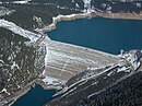 |
| Revelstoke Dam | 175 m (574 ft)[6] | 2,480[5] | British Columbia | 51°02′57″N 118°11′36″W / 51.04917°N 118.19333°W / 51.04917; -118.19333 (Revelstoke Dam) | 1984 | BC Hydro | Revelstoke Lake | 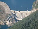 |
| Keenleyside Dam | 52 m (171 ft)[7] | 185[8] | British Columbia | 49°20′18″N 117°46′18″W / 49.33833°N 117.77167°W / 49.33833; -117.77167 (Keenleyside Dam) | 1968 | BC Hydro | Raised Arrow Lakes |  |
| Grand Coulee Dam | 550 ft (170 m)[9] | 6,809[9] |  Washington Washington | 47°57′26″N 118°58′39″W / 47.95722°N 118.97750°W / 47.95722; -118.97750 (Grand Coulee Dam) | 1941 / 1974 [n 1] | USBR | Franklin D. Roosevelt Lake |  |
| Chief Joseph Dam | 236 ft (72 m)[10] | 2,620[11] | Washington | 47°59′42″N 119°38′19″W / 47.99500°N 119.63861°W / 47.99500; -119.63861 (Chief Joseph Dam) | 1955 | USACE | Rufus Woods Lake |  |
| Wells Dam | 160 ft (49 m)[12] | 840[13] | Washington | 47°56′50″N 119°51′51″W / 47.94722°N 119.86417°W / 47.94722; -119.86417 (Wells Dam) | 1967 | Douglas PUD | Lake Pateros |  |
| Rocky Reach Dam | 130 ft (40 m)[14] | 1,287[15] | Washington | 47°31′59″N 120°17′41″W / 47.53306°N 120.29472°W / 47.53306; -120.29472 (Rocky Reach Dam) | 1961 | Chelan PUD | Lake Entiat | 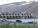 |
| Rock Island Dam | 135 ft (41 m)[16] | 660[17] | Washington | 47°20′33″N 120°05′40″W / 47.34250°N 120.09444°W / 47.34250; -120.09444 (Rock Island Dam) | 1933[18] | Chelan PUD | Rock Island Pool | 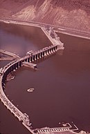 |
| Wanapum Dam | 185 ft (56 m)[19] | 1,092[19] | Washington | 46°52′40″N 119°58′13″W / 46.87778°N 119.97028°W / 46.87778; -119.97028 (Wanapum Dam) | 1963 | Grant PUD | Lake Wanapum |  |
| Priest Rapids Dam | 178 ft (54 m)[20] | 955.6[21] | Washington | 46°38′39″N 119°54′36″W / 46.64417°N 119.91000°W / 46.64417; -119.91000 (Priest Rapids Dam) | 1961 | Grant PUD | Priest Rapids Lake |  |
| McNary Dam | 183 ft (56 m)[22] | 1,133[23] | Washington /  Oregon border Oregon border | 45°56′07″N 119°17′53″W / 45.93528°N 119.29806°W / 45.93528; -119.29806 (McNary Dam) | 1954 | USACE | Lake Wallula |  |
| John Day Dam | 184 ft (56 m) | 2,485[24] | Washington / Oregon border | 45°42′57″N 120°41′37″W / 45.71583°N 120.69361°W / 45.71583; -120.69361 (John Day Dam) | 1971 | USACE | Lake Umatilla | 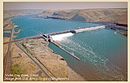 |
| The Dalles Dam | 260 ft (79 m) | 2,038[25] | Washington / Oregon border | 45°36′50″N 121°08′02″W / 45.61389°N 121.13389°W / 45.61389; -121.13389 (The Dalles Dam) | 1957 | USACE | Lake Celilo |  |
| Bonneville Dam | 197 ft (60 m)[26] | 1,190[27] | Washington / Oregon border | 45°38′42″N 121°56′27″W / 45.64500°N 121.94083°W / 45.64500; -121.94083 (Bonneville Dam) | 1937 / 1981 [n 2] | USACE | Lake Bonneville |  |
Snake River dams
Dams are listed in order from headwater (Two Oceans Plateau, WY) to mouth Columbia River, WA.
| Name | Height | Capacity (MW) | Province/State(s) | Coordinates | Year of completion | Owner | Reservoir formed | Image |
|---|---|---|---|---|---|---|---|---|
| Jackson Lake Dam | 65.5 ft (20.0 m)[28] | 0 |  Wyoming Wyoming | 43°51′30″N 110°35′24″W / 43.85833°N 110.59000°W / 43.85833; -110.59000 (Jackson Lake Dam) | 1911 / 1916 / 1989[n 3] | USBR | Jackson Lake |  |
| Palisades Dam | 270 ft (82 m)[29] | 176.6[29] |  Idaho Idaho | 43°19′59″N 111°12′12″W / 43.33306°N 111.20333°W / 43.33306; -111.20333 (Palisades Dam) | 1957 | USBR | Palisades Reservoir | 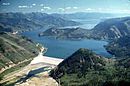 |
| Gem State Dam | 40 ft (12 m) | 22.6[30] | Idaho | 43°25′19″N 112°06′08″W / 43.42194°N 112.10222°W / 43.42194; -112.10222 (Gem State Dam) | 1982 | City of Idaho Falls | ||
| American Falls Dam | 104 ft (32 m)[31] | 112.4[32] | Idaho | 42°46′43″N 112°52′35″W / 42.77861°N 112.87639°W / 42.77861; -112.87639 (American Falls Dam) | 1927 / 1978[n 4] | USBR | American Falls Reservoir | 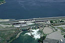 |
| Minidoka Dam | 86 ft (26 m)[33] | 28.5[33] | Idaho | 42°40′10″N 113°29′03″W / 42.66944°N 113.48417°W / 42.66944; -113.48417 (Minidoka Dam) | 1909-1942[33] | USBR | Lake Walcott |  |
| Milner Dam | 38 ft (12 m)[34] | 59.5[35] | Idaho | 42°31′30″N 114°00′35″W / 42.52500°N 114.00972°W / 42.52500; -114.00972 (Milner Dam) | 1905 | Milner Dam, Inc. | Milner Lake |  |
| Twin Falls Dam | 25 ft (7.6 m)[n 5] | 52.9[36] | Idaho | 42°35′21″N 114°21′20″W / 42.58917°N 114.35556°W / 42.58917; -114.35556 (Twin Falls Dam) | 1935 / 1995[n 6] | Idaho Power Company | Twin Falls Reservoir[n 5] |  |
| Shoshone Falls Dam | 16 ft (4.9 m)[37] | 64[38] | Idaho | 42°35′47″N 114°24′04″W / 42.59639°N 114.40111°W / 42.59639; -114.40111 (Shoshone Falls Dam) | 1907[38] | Idaho Power Company | Shoshone Falls Reservoir | 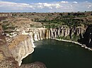 |
| Upper Salmon Falls Dam | 18 ft (5.5 m)[n 5] | 34.5[35] | Idaho | 42°45′59″N 114°53′45″W / 42.76639°N 114.89583°W / 42.76639; -114.89583 (Upper Salmon Falls Dam) | 1937 / 1947[n 7] | Idaho Power Company | Upper Salmon Falls Reservoir[n 5] | |
| Lower Salmon Falls Dam | 38 ft (12 m)[39] | 60[35] | Idaho | 42°50′30″N 114°54′54″W / 42.84167°N 114.91500°W / 42.84167; -114.91500 (Lower Salmon Falls Dam) | 1910 / 1949[n 8] | Idaho Power Company | Lower Salmon Falls Reservoir | |
| Bliss Dam | 84 ft (26 m)[39] | 75[35] | Idaho | 42°54′49″N 115°04′16″W / 42.91361°N 115.07111°W / 42.91361; -115.07111 (Bliss Dam) | 1950 | Idaho Power Company | Bliss Reservoir | |
| C. J. Strike Dam | 115 ft (35 m) | 82.8[40] | Idaho | 42°56′51″N 115°58′31″W / 42.94750°N 115.97528°W / 42.94750; -115.97528 (C. J. Strike Dam) | 1952[40] | Idaho Power Company | C. J. Strike Reservoir | |
| Swan Falls Dam | 107 ft (33 m) | 25[n 9] | Idaho | 43°14′35″N 116°22′46″W / 43.24306°N 116.37944°W / 43.24306; -116.37944 (Swan Falls Dam) | 1901 | Idaho Power Company | Swan Falls Reservoir[n 5] |  |
| Brownlee Dam | 420 ft (130 m)[43] | 585[44] | Idaho / Oregon border | 44°50′13″N 116°54′03″W / 44.83694°N 116.90083°W / 44.83694; -116.90083 (Brownlee Dam) | 1959 / 1980[n 10] | Idaho Power Company | Brownlee Reservoir | 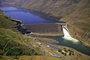 |
| Oxbow Dam | 175 ft (53 m)[45] | 220[46] | Idaho / Oregon border | 44°58′15″N 116°50′07″W / 44.97083°N 116.83528°W / 44.97083; -116.83528 (Oxbow Dam) | 1961 | Idaho Power Company | Oxbow Reservoir |  |
| Hells Canyon Dam | 330 ft (100 m)[47] | 450[48] | Idaho / Oregon border | 45°14′34″N 116°42′05″W / 45.24278°N 116.70139°W / 45.24278; -116.70139 (Hells Canyon Dam) | 1967 | Idaho Power Company | Hells Canyon Reservoir | 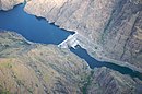 |
| Lower Granite Dam | 181 ft (55 m)[49] | 932[50] | Washington | 46°39′40″N 117°25′41″W / 46.66111°N 117.42806°W / 46.66111; -117.42806 (Lower Granite Dam) | 1975 / 1987 [n 11] | USACE | Lower Granite Lake |  |
| Little Goose Dam | 253 ft (77 m)[52] | 932[53] | Washington | 46°35′13″N 118°01′40″W / 46.58694°N 118.02778°W / 46.58694; -118.02778 (Little Goose Dam) | 1970 | USACE | Lake Bryan |  |
| Lower Monumental Dam | 152 ft (46 m)[54] | 930[55] | Washington | 46°33′48″N 118°32′20″W / 46.56333°N 118.53889°W / 46.56333; -118.53889 (Lower Monumental Dam) | 1969 | USACE | Lake Herbert G. West |  |
| Ice Harbor Dam | 213 ft (65 m)[56] | 693[57] | Washington | 46°14′58″N 118°52′47″W / 46.24944°N 118.87972°W / 46.24944; -118.87972 (Ice Harbor Dam) | 1961 / 1976 [n 12] | USACE | Lake Sacajawea |  |
Salmon River dams
Little Salmon River dams
Dams are listed in order from headwater (north West Mountain, ID) to mouth (Salmon River, ID)
| Name | Height | Capacity (MW) | Province/State(s) | Coordinates | Year of completion | Owner | Reservoir formed | Image |
|---|---|---|---|---|---|---|---|---|
| Goose Lake Dam (Goose Creek)[58] | 26 ft (7.9 m) | 0 | Idaho | 45°04′13″N 116°10′09″W / 45.07028°N 116.16917°W / 45.07028; -116.16917 (Goose Lake Dam) | 1924 | Ca Campbell Company | Goose Lake | |
| Brundage Dam (Brundage Creek(Goose Creek))[59] | 64 ft (20 m) | 0 | Idaho | 45°02′30″N 116°07′53″W / 45.04167°N 116.13139°W / 45.04167; -116.13139 (Brundage Dam) | 1989 | Brundage Reservoir Company | Brundage Reservoir |
Owyhee River dams
Dams are listed in order from headwater (near Double Mountain, NV) to mouth (Snake River, OR/ID)
| Name | Height | Capacity (MW) | Province/State(s) | Coordinates | Year of completion | Owner | Reservoir formed | Image |
|---|---|---|---|---|---|---|---|---|
| Wild Horse Dam | 114 ft (35 m)[60][61] | 0 |  Nevada Nevada | 41°41′14″N 115°50′43″W / 41.68722°N 115.84528°W / 41.68722; -115.84528 (Wild Horse Dam) | 1937 / 1969[n 13] | BIA[63] | Wild Horse Reservoir |  |
| Antelope Reservoir Dam (Antelope Creek (Jordan Creek))[64] | 60 ft (18 m) | 0 | Oregon | 42°54′0″N 117°13′48″W / 42.90000°N 117.23000°W / 42.90000; -117.23000 (Antelope Reservoir Dam) | 1923 | Jordan Valley Irrigation District | Antelope Reservoir | |
| Owyhee Dam | 417 ft (127 m)[65] | 5[n 14],8[n 15],2[n 16] | Oregon | 43°38′31″N 117°14′33″W / 43.64194°N 117.24250°W / 43.64194; -117.24250 (Owyhee Dam) | 1932[65] | USBR | Lake Owyhee |  |
Dams are listed in order from headwater (north Tuscarora Mountains, NV) to mouth (Owyhee River, ID)
| Name | Height | Capacity (MW) | Province/State(s) | Coordinates | Year of completion | Owner | Reservoir formed | Image |
|---|---|---|---|---|---|---|---|---|
| Wilson Reservoir Dam (Wilson Creek)[66] | 34 ft (10 m) | 0 | Nevada | 41°40′12″N 116°20′24″W / 41.67000°N 116.34000°W / 41.67000; -116.34000 (Wilson Reservoir Dam) | Petan Company | Wilson Reservoir | ||
| Bull Run Dam (Bull Run Creek)[67] | 69 ft (21 m) | 0 | Nevada | 41°38′24″N 116°09′0″W / 41.64000°N 116.15000°W / 41.64000; -116.15000 (Bull Run Dam) | Petan Company | Bull Run Reservoir | ||
| Dry Creek Dam (Indian Creek)[68] | 70 ft (21 m) | 0 | Nevada | 41°47′24″N 116°13′48″W / 41.79000°N 116.23000°W / 41.79000; -116.23000 (Dry Creek Dam) | Petan Company | Dry Creek Reservoir | ||
| Rawhide Reservoir Dam (Indian Creek)[69] | 33 ft (10 m) | 0 | Nevada | 41°42′36″N 116°20′24″W / 41.71000°N 116.34000°W / 41.71000; -116.34000 (Rawhide Reservoir Dam) | Petan Company | Rawhide Reservoir | ||
| Sheep Creek Dam (Sheep Creek)[70] | 29 ft (8.8 m) | 0 | Nevada | 41°51′36″N 116°16′12″W / 41.86000°N 116.27000°W / 41.86000; -116.27000 (Sheep Creek Dam) | 1966 | United States Bureau of Indian Affairs, Shoshone and Paiute Tribes | Sheep Creek Reservoir | |
| Chimney Creek Dam (Fourmile Creek)[71] | 20 ft (6.1 m) | 0 | Nevada | 41°42′36″N 116°32′24″W / 41.71000°N 116.54000°W / 41.71000; -116.54000 (Chimney Creek Dam) | Roaring Springs Associates | Desert Ranch Reservoir |
Malheur River dams
Dams are listed in order from headwater (Logan Valley, OR) to mouth (Snake River, OR/ID)
| Name | Height | Capacity (MW) | Province/State(s) | Coordinates | Year of completion | Owner | Reservoir formed | Image |
|---|---|---|---|---|---|---|---|---|
| Warm Springs Dam[72][73] | 106 ft (32 m) | proposed 2.7[74] | Oregon | 43°35′07″N 118°12′31″W / 43.58528°N 118.20861°W / 43.58528; -118.20861 (Warm Springs Dam) | 1919 | United States Bureau of Reclamation | Warm Springs Reservoir |  |
| Agency Valley Dam (North Fork Malheur River)[73][75] | 110 ft (34 m) | proposed 2.0[76] | Oregon | 43°54′41″N 118°09′15″W / 43.91139°N 118.15417°W / 43.91139; -118.15417 (Agency Valley Dam) | 1935 | United States Bureau of Reclamation | Beulah Reservoir |  |
| Harper Diversion Dam[73] | 12 ft (3.7 m) | 0 | Oregon | 43°49′29″N 117°38′32″W / 43.82472°N 117.64222°W / 43.82472; -117.64222 (Harper Diversion) | 1930 | United States Bureau of Reclamation | Harper Diversion Pool | |
| Bully Creek Dam (Bully Creek)[73][77] | 121 ft (37 m) | 0 | Oregon | 44°00′55″N 117°23′48″W / 44.01528°N 117.39667°W / 44.01528; -117.39667 (Bully Creek Dam) | 1963 | United States Bureau of Reclamation | Bully Creek Reservoir |  |
| Bully Creek Diversion Dam (Bully Creek)[73] | 4 ft (1.2 m) | 0 | Oregon | 44°00′11″N 117°23′03″W / 44.00306°N 117.38417°W / 44.00306; -117.38417 (Bully Creek Diversion) | 1964 | United States Bureau of Reclamation | Bully Creek Diversion Pool | |
| Willow Creek Reservoir #3 Dam (Willow Creek)[78] | 110 ft (34 m) | 0 | Oregon | 44°21′11″N 117°40′16″W / 44.35306°N 117.67111°W / 44.35306; -117.67111 (Willow Creek Reservoir #3 Dam) | 1944 | Orchard Water Company | Malheur Reservoir |  |
Grande Ronde River dams
Wallowa River dams
Dams are listed in order from headwater (near Pete's Point, Eagle Cap Wilderness, OR) to mouth (Grande Ronde River, OR)
| Name | Height | Capacity (MW) | Province/State(s) | Coordinates | Year of completion | Owner | Reservoir formed | Image |
|---|---|---|---|---|---|---|---|---|
| Wallowa Lake Dam[79] | 40 ft (12 m) | 0 | Oregon | 45°19′48″N 117°13′12″W / 45.33000°N 117.22000°W / 45.33000; -117.22000 (Wallowa Lake Dam) | 1931 | Associated Ditch Companies | Raised Wallowa Lake |
Powder River dams
Dams are listed in order from headwater (confluence of McCully Fork and Cracker Creek, OR) to mouth (Snake River, OR/ID)
| Name | Height | Capacity (MW) | Province/State(s) | Coordinates | Year of completion | Owner | Reservoir formed | Image |
|---|---|---|---|---|---|---|---|---|
| Mason Dam[80][81] | 173 ft (53 m) | proposed 3.4[82] | Oregon | 44°40′12″N 117°59′24″W / 44.67000°N 117.99000°W / 44.67000; -117.99000 (Mason Dam) | 1968 | United States Bureau of Reclamation | Philips Lake |  |
| Thief Valley Dam[81][83] | 73 ft (22 m) | 0 | Oregon | 45°0′36″N 117°46′12″W / 45.01000°N 117.77000°W / 45.01000; -117.77000 (Thief Valley Dam) | 1932 | United States Bureau of Reclamation | Thief Valley Reservoir |
Blackfoot River dams
Dams are listed in order from headwater (confluence of Diamond and Lanes Creeks, ID) to mouth (Snake River, ID)
| Name | Height | Capacity (MW) | Province/State(s) | Coordinates | Year of completion | Owner | Reservoir formed | Image |
|---|---|---|---|---|---|---|---|---|
| Blackfoot Dam | 44 ft (13 m)[84] | 0 | Idaho | 43°0′0″N 111°42′36″W / 43.00000°N 111.71000°W / 43.00000; -111.71000 (Blackfoot Dam)[85] | 1911[85] | United States Bureau of Indian Affairs[85] | Blackfoot Reservoir |
Henrys Fork dams
Dams are listed in order from headwater (Henrys Lake, ID) to mouth (Snake River, ID)
| Name | Height | Capacity (MW) | Province/State(s) | Coordinates | Year of completion | Owner | Reservoir formed | Image |
|---|---|---|---|---|---|---|---|---|
| Henrys Lake Dam | 18 ft (5.5 m)[86] | 0 | Idaho | 44°35′24″N 111°21′0″W / 44.59000°N 111.35000°W / 44.59000; -111.35000 (Henrys Lake Dam)[86] | 1923[86] | North Fork Reservoir Company[86] | Raised Henrys Lake | |
| Island Park Dam | 94 ft (29 m)[87] | 4.8[32] | Idaho | 44°25′12″N 111°23′24″W / 44.42000°N 111.39000°W / 44.42000; -111.39000 (Island Park Dam)[87] | 1938[87] | United States Bureau of Reclamation[32] | Island Park Reservoir |  |
| Buffalo River Dam (Buffalo River)[88] | 12 ft (3.7 m) | 0.25 | Idaho | 44°24′52″N 111°23′34″W / 44.41444°N 111.39278°W / 44.41444; -111.39278 (Buffalo River Dam) | 1980 | Fall River Rural Electric Cooperative, Inc. | Buffalo Dam Pool | |
| Ashton Dam[89] | 56.6 ft (17.3 m) | 6.85 | Idaho | 44°04′12″N 111°29′24″W / 44.07000°N 111.49000°W / 44.07000; -111.49000 (Ashton Dam)[90] | 1913[90] | PacifiCorp | Ashton Dam Lake | |
| Chester Dam (Crosscut Diversion Dam)[91] | 14.5 ft (4.4 m) | 3.3[92] | Idaho | 44°0′36″N 111°34′48″W / 44.01000°N 111.58000°W / 44.01000; -111.58000 (Chester Dam) | 1938 | Fremont-Madison Irrigation District | Chester Dam Pool |
Fall River dams
Dams are listed in order from headwater (Pitchstone Plateau, WY) to mouth (Henrys Fork, ID)
| Name | Height | Capacity (MW) | Province/State(s) | Coordinates | Year of completion | Owner | Reservoir formed | Image |
|---|---|---|---|---|---|---|---|---|
| Grassy Lake Dam (Grassy Creek) | 118 ft (36 m)[32] | 0 | Wyoming | 44°07′48″N 110°48′36″W / 44.13000°N 110.81000°W / 44.13000; -110.81000 (Grassy Lake Dam)[93] | 1939[93] | United States Bureau of Reclamation[32] | Grassy Lake | 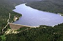 |
Portneuf River dams
Dams are listed in order from headwater (southeast of Higham Peak, ID) to mouth (Snake River, ID)
| Name | Height | Capacity (MW) | Province/State(s) | Coordinates | Year of completion | Owner | Reservoir formed | Image |
|---|---|---|---|---|---|---|---|---|
| Portneuf Dam[94] | 47 ft (14 m) | 0 | Idaho | 42°52′12″N 111°56′24″W / 42.87000°N 111.94000°W / 42.87000; -111.94000 (Portneuf Dam) | 1912 | Portneuf-Marsh Valley Canal Company | Chesterfield Reservoir |
Salmon Falls Creek dams
Dams are listed in order from headwater (Jarbidge Mountains, NV) to mouth (Snake River, ID)
| Name | Height | Capacity (MW) | Province/State(s) | Coordinates | Year of completion | Owner | Reservoir formed | Image |
|---|---|---|---|---|---|---|---|---|
| Salmon Falls Dam[95] | 217 ft (66 m) | 0 | Idaho | 42°12′36″N 114°43′48″W / 42.21000°N 114.73000°W / 42.21000; -114.73000 (Salmon Falls Dam) | 1911 | Salmon River Canal Company, Ltd. | Salmon Falls Creek Reservoir | 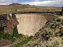 |
| Cedar Creek Dam (Cedar Creek)[96] | 84 ft (26 m) | 0 | Idaho | 42°13′12″N 114°52′12″W / 42.22000°N 114.87000°W / 42.22000; -114.87000 (Cedar Creek Dam) | 1920 | Cedar Mesa Reservoir And Canal Company | Cedar Creek Reservoir |
Boise River dams
Dams are listed in order from headwater (confluence of North and Middle Forks Boise River, ID) to mouth (Snake River, ID/OR)
| Name | Height | Capacity (MW) | Province/State(s) | Coordinates | Year of completion | Owner | Reservoir formed | Image |
|---|---|---|---|---|---|---|---|---|
| Arrowrock Dam[97] | 350 ft (110 m) | 15[98] | Idaho | 43°36′0″N 115°55′12″W / 43.60000°N 115.92000°W / 43.60000; -115.92000 (Arrowrock Dam) | 1915 | United States Bureau of Reclamation | Arrowrock Reservoir |  |
| Lucky Peak Dam[99] | 340 ft (100 m) | 101.25[100] | Idaho | 43°31′12″N 116°03′0″W / 43.52000°N 116.05000°W / 43.52000; -116.05000 (Lucky Peak Dam) | 1955 | United States Army Corps of Engineers | Lucky Peak Lake | 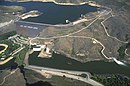 |
| Boise River Diversion Dam[101] | 68 ft (21 m) | 3.3[98] | Idaho | 43°31′48″N 116°05′24″W / 43.53000°N 116.09000°W / 43.53000; -116.09000 (Boise River Diversion Dam) | 1908 | United States Bureau of Reclamation | Boise River Diversion Dam Pool | 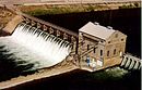 |
| Barber Dam[102] | 25 ft (7.6 m) | 4.14[103] | Idaho | 43°34′12″N 116°07′12″W / 43.57000°N 116.12000°W / 43.57000; -116.12000 (Barber Dam) | 1904 | Ada County and Fulcrum Inc. | Barber Dam Pool | 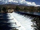 |
Dams are listed in order from headwater (confluence of Ross Fork and Johnson Creek, ID) to mouth (Boise River, ID)
| Name | Height | Capacity (MW) | Province/State(s) | Coordinates | Year of completion | Owner | Reservoir formed | Image |
|---|---|---|---|---|---|---|---|---|
| Anderson Ranch Dam[104] | 456 ft (139 m) | 40[98] | Idaho | 43°21′36″N 115°26′24″W / 43.36000°N 115.44000°W / 43.36000; -115.44000 (Anderson Ranch Dam) | 1947 | United States Bureau of Reclamation | Anderson Ranch Reservoir | 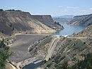 |
| Little Camas Dam (Little Camas Creek)[105] | 44 ft (13 m) | 0 | Idaho | 43°21′0″N 115°22′48″W / 43.35000°N 115.38000°W / 43.35000; -115.38000 (Little Camas Dam) | 1912 | Mountain Home Irrigation District | Little Camas Reservoir |
Goose Creek dams
Dams are listed in order from headwater (near Monument Peak, ID) to mouth (Snake River, ID)
| Name | Height | Capacity (MW) | Province/State(s) | Coordinates | Year of completion | Owner | Reservoir formed | Image |
|---|---|---|---|---|---|---|---|---|
| Oakley Dam[106] | 139 ft (42 m) | 0 | Idaho | 42°11′24″N 113°54′36″W / 42.19000°N 113.91000°W / 42.19000; -113.91000 (Oakley Dam) | 1916 | Oakley Canal Company | Lower Goose Creek Reservoir |
Weiser River dams
Dams are listed in order from headwater (near Brush Mountain, ID) to mouth (Snake River, ID/OR)
| Name | Height | Capacity (MW) | Province/State(s) | Coordinates | Year of completion | Owner | Reservoir formed | Image |
|---|---|---|---|---|---|---|---|---|
| Lost Valley Dam (Lost Creek(West Fork Weiser River))[107] | 52 ft (16 m) | 0 | Idaho | 44°57′23″N 116°28′02″W / 44.95639°N 116.46722°W / 44.95639; -116.46722 (Lost Valley Dam) | 1929 | Lost Valley Reservoir Company | Lost Valley Reservoir | |
| C Ben Ross Dam (Little Weiser River)[108] | 56 ft (17 m) | 0 | Idaho | 44°31′12″N 116°26′24″W / 44.52000°N 116.44000°W / 44.52000; -116.44000 (C Ben Ross Dam) | 1937 | Little Weiser River Irrigation District | Ben Ross Reservoir | |
| Crane Creek Dam (Crane Creek)[109] | 55 ft (17 m) | 0 | Idaho | 44°21′0″N 116°36′36″W / 44.35000°N 116.61000°W / 44.35000; -116.61000 (Crane Creek Dam) | 1912 | Crane Creek Reservoir Administration Board | Crane Creek Reservoir | |
| Mann Creek Dam (Mann Creek)[110] | 148 ft (45 m) | 0[111] | Idaho | 44°23′24″N 116°53′24″W / 44.39000°N 116.89000°W / 44.39000; -116.89000 (Mann Creek Dam) | 1967 | United States Bureau of Reclamation | Mann Creek Reservoir |
|

Burnt River dams
Dams are listed in order from headwater (confluence of North and South Fork Burnt Rivers, OR) to mouth (Snake River, OR/ID)
| Name | Height | Capacity (MW) | Province/State(s) | Coordinates | Year of completion | Owner | Reservoir formed | Image |
|---|---|---|---|---|---|---|---|---|
| Unity Dam[112][113] | 82 ft (25 m) | proposed 0.8[114] | Oregon | 43°30′0″N 118°10′48″W / 43.50000°N 118.18000°W / 43.50000; -118.18000 (Unity Dam) | 1938 | United States Bureau of Reclamation | Unity Reservoir | |
Willow Creek dams
Dams are listed in order from headwater (Blackfoot Mountains, ID) to mouth (Snake River, ID)
| Name | Height | Capacity (MW) | Province/State(s) | Coordinates | Year of completion | Owner | Reservoir formed | Image |
|---|---|---|---|---|---|---|---|---|
| Ririe Dam | 253 ft (77 m)[115] | 0 | Idaho | 43°34′48″N 111°44′24″W / 43.58000°N 111.74000°W / 43.58000; -111.74000 (Ririe Dam)[116] | 1977[116] | United States Bureau of Reclamation[116] | Ririe Reservoir | 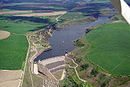 |
Payette River dams
Dams are listed in order from headwater (confluence of South and Middle Forks Payette River, ID) to mouth (Snake River, ID/OR)
| Name | Height | Capacity (MW) | Province/State(s) | Coordinates | Year of completion | Owner | Reservoir formed | Image |
|---|---|---|---|---|---|---|---|---|
| Black Canyon Diversion Dam[117] | 183 ft (56 m) | 10.2[98] | Idaho | 43°52′48″N 116°28′48″W / 43.88000°N 116.48000°W / 43.88000; -116.48000 (Black Canyon Diversion Dam) | 1924 | United States Bureau of Reclamation | Black Canyon Reservoir |  |
Dams are listed in order from headwater (Squaw Meadows, ID) to mouth (Payette River, ID)
| Name | Height | Capacity (MW) | Province/State(s) | Coordinates | Year of completion | Owner | Reservoir formed | Image |
|---|---|---|---|---|---|---|---|---|
| Upper Payette Lake Dam[118] | 18 ft (5.5 m) | 0 | Idaho | 45°06′40″N 116°01′35″W / 45.11111°N 116.02639°W / 45.11111; -116.02639 (Upper Payette Lake Dam) | 1952 | Lake Reservoir Company | Upper Payette Lake | |
| Granite Lake Dam (Fisher Creek)[119] | 28 ft (8.5 m) | 0 | Idaho | 45°06′02″N 116°04′51″W / 45.10056°N 116.08083°W / 45.10056; -116.08083 (Granite Lake Dam) | 1963 | Lake Reservoir Company | Granite Lake | |
| Payette Lake Dam[120] | 8.2 ft (2.5 m) | 0 | Idaho | 44°54′36″N 116°06′36″W / 44.91000°N 116.11000°W / 44.91000; -116.11000 (Payette Lake Dam) | 1943 | Lake Reservoir Company | Raised Payette Lake | |
| Little Payette Lake Dam (Lake Fork)[121] | 15.8 ft (4.8 m) | 0 | Idaho | 44°54′0″N 116°02′24″W / 44.90000°N 116.04000°W / 44.90000; -116.04000 (Little Payette Lake Dam) | 1926 | Lake Fork Irrigation District | Little Payette Lake | |
| Cascade Dam[122] | 107 ft (33 m) | 12.8[98] | Idaho | 44°31′12″N 116°03′0″W / 44.52000°N 116.05000°W / 44.52000; -116.05000 (Cascade Dam) | 1948 | United States Bureau of Reclamation | Lake Cascade |  |
| Sage Hen Dam(Sage Hen Creek(Second Fork Squaw Creek))[123] | 38 ft (12 m) | 0 | Idaho | 44°19′12″N 116°11′24″W / 44.32000°N 116.19000°W / 44.32000; -116.19000 (Sage Hen Dam) | 1938 | Squaw Creek Irrigation Company | Sage Hen Reservoir | |
| Paddock Valley Dam (Little Willow Creek)[124] | 43 ft (13 m) | 0 | Idaho | 44°11′24″N 116°35′24″W / 44.19000°N 116.59000°W / 44.19000; -116.59000 (Paddock Valley Dam) | 1949 | Little Willow Irrigation District | Paddock Valley Reservoir |
Dams are listed in order from headwater (near Vernon Lake, ID) to mouth (Payette River, ID)
| Name | Height | Capacity (MW) | Province/State(s) | Coordinates | Year of completion | Owner | Reservoir formed | Image |
|---|---|---|---|---|---|---|---|---|
| Deadwood Dam (Deadwood River)[125] | 183 ft (56 m) | 0[98] | Idaho | 44°17′24″N 115°38′24″W / 44.29000°N 115.64000°W / 44.29000; -115.64000 (Deadwood Dam) | 1931 | United States Bureau of Reclamation | Deadwood Reservoir | 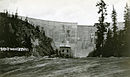 |
Clearwater River dams
Dams are listed in order from headwater (near Illinois Peak, ID/MT) to mouth (Clearwater River, ID)
| Name | Height | Capacity (MW) | Province/State(s) | Coordinates | Year of completion | Owner | Reservoir formed | Image |
|---|---|---|---|---|---|---|---|---|
| Dworshak Dam | 717 ft (219 m)[126] | 400 | Idaho | 46°30′N 116°18′W / 46.500°N 116.300°W / 46.500; -116.300 (Dworshak Dam) | 1973 | Army Corps of Engineers | Dworshak Reservoir | 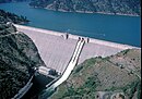 |
Malad River dams
| Name | Height | Capacity (MW) | Province/State(s) | Coordinates | Year of completion | Owner | Reservoir formed | Image |
|---|---|---|---|---|---|---|---|---|
| Upper Malad River Dam | 124.1 ft (37.8 m)[127] | 8.27[128] | Idaho | 42°51′55″N 114°52′09″W / 42.86539°N 114.86925°W / 42.86539; -114.86925 (Upper Malad Dam) | 1948[128] | Idaho Power Company | Malad Gorge State Park | |
| Lower Malad River Dam | 152.0 ft (46.3 m)[127] | 13.50[128] | Idaho | 42°51′51″N 114°53′08″W / 42.86416°N 114.88566°W / 42.86416; -114.88566 (Upper Malad Dam) | 1911[128] | Idaho Power Company | Malad Gorge State Park |
Big Wood River dams
Dams are listed in order from headwater (near Galena Summit, ID) to mouth (Malad River, ID)
| Name | Height | Capacity (MW) | Province/State(s) | Coordinates | Year of completion | Owner | Reservoir formed | Image |
|---|---|---|---|---|---|---|---|---|
| Magic Dam | 128 ft (39 m)[129] | 9[130] | Idaho | 43°15′0″N 114°22′12″W / 43.25000°N 114.37000°W / 43.25000; -114.37000 (Magic Dam)[129] | 1910[129] | Magic Reservoir Hydroelectric, Inc.[129] | Magic Reservoir |
Camas Creek
Dams are listed in order from headwater (near Packer Butte, ID) to mouth (Big Wood River, ID)
| Name | Height | Capacity (MW) | Province/State(s) | Coordinates | Year of completion | Owner | Reservoir formed | Image |
|---|---|---|---|---|---|---|---|---|
| Mormon Dam (McKinney Creek) | 23 ft (7.0 m)[131] | 0 | Idaho | 43°16′48″N 114°48′0″W / 43.28000°N 114.80000°W / 43.28000; -114.80000 (Mormon Dam) | 1908 | Twin Lakes Reservoir and Irrigation Company | Mormon Reservoir |
Little Wood River dams
Dams are listed in order from headwater (Standhope Peak, ID) to mouth (Malad River, ID)
| Name | Height | Capacity (MW) | Province/State(s) | Coordinates | Year of completion | Owner | Reservoir formed | Image |
|---|---|---|---|---|---|---|---|---|
| Little Wood River Dam | 169 ft (52 m)[132] | 3[133] | Idaho | 43°25′12″N 114°01′12″W / 43.42000°N 114.02000°W / 43.42000; -114.02000 (Little Wood Dam)[132] | 1962[132] | United States Bureau of Reclamation[132] | Little Wood Reservoir |
|
| Fish Creek Dam (Fish Creek) | 88 ft (27 m)[134] | 0 | Idaho | 43°25′12″N 114°49′48″W / 43.42000°N 114.83000°W / 43.42000; -114.83000 (Fish Creek Dam)[134] | 1923[134] | Carey Valley Reservoir Company[134] | Fish Creek Reservoir |

Kootenay River dams
Dams are listed in order from headwater (near Castle Mountain, Beaverfoot Range, BC) to mouth (Columbia River, BC).
| Name | Height | Capacity (MW) | Province/State(s) | Coordinates | Year of completion | Owner | Reservoir formed | Image |
|---|---|---|---|---|---|---|---|---|
| Libby Dam | 420 ft (130 m)[135] | 604[136] |  Montana Montana | 48°24′37″N 115°18′52″W / 48.41028°N 115.31444°W / 48.41028; -115.31444 (Libby Dam) | 1972[137] | USACE | Lake Koocanusa |  |
| Corra Linn Dam | 16 m (52 ft)[138] | 51[138] | British Columbia | 49°28′04″N 117°28′02″W / 49.46778°N 117.46722°W / 49.46778; -117.46722 (Corra Linn Dam) | 1932[138] | FortisBC | raised Kootenay Lake |  |
| Upper Bonnington Falls Dam | 21 m (69 ft)[139] | 53[8] | British Columbia | 49°27′35″N 117°29′03″W / 49.45972°N 117.48417°W / 49.45972; -117.48417 (Upper Bonnington Falls Dam) | 1907[8] | FortisBC | ||
| Lower Bonnington Falls Dam | 21 m (69 ft)[140] | 25[8] | British Columbia | 49°27′39″N 117°29′59″W / 49.46083°N 117.49972°W / 49.46083; -117.49972 (Lower Bonnington Falls Dam) | 1925[8] | FortisBC |  | |
| South Slocan Dam | 18 m (59 ft)[141] | 57[8] | British Columbia | 49°27′20″N 117°31′11″W / 49.45556°N 117.51972°W / 49.45556; -117.51972 (South Slocan Dam) | 1928[8] | FortisBC |  | |
| Kootenay Canal Generating Station[n 17] | 84 m (276 ft)[142] | 583[8] | British Columbia | 49°27′10″N 117°31′02″W / 49.45278°N 117.51722°W / 49.45278; -117.51722 (Kootenay Canal Generating Station) | 1976[8] | BC Hydro | 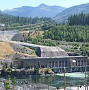 | |
| Brilliant Dam | 42.6 m (140 ft)[143] | 260[n 18] | British Columbia | 49°19′29″N 117°37′12″W / 49.32472°N 117.62000°W / 49.32472; -117.62000 (Brilliant Dam) | 1944 / 2007[n 18] | Columbia Power Corporation |  |
Bull River dams
Dams are listed in order from headwater (Canadian Rockies) to mouth (Kootenay River, BC).
| Name | Height | Capacity (MW) | Province/State(s) | Coordinates | Year of completion | Owner | Reservoir formed | Image |
|---|---|---|---|---|---|---|---|---|
| Aberfeldie Dam[144] | 90 ft (27 m) | 24[145] | British Columbia | 49°29′58″N 115°21′3″W / 49.49944°N 115.35083°W / 49.49944; -115.35083 (Aberfeldie Dam) | 1922 (rebuilt 1953) | BC Hydro | Aberfeldie Dam Pool |
Elk River dams
Dams are listed in order from headwater (Upper Elk Lake) to mouth (Kootenay River, BC).
| Name | Height | Capacity (MW) | Province/State(s) | Coordinates | Year of completion | Owner | Reservoir formed | Image |
|---|---|---|---|---|---|---|---|---|
| Elko Dam[146] | 52 ft (16 m) | 12[147] | British Columbia | 49°17′24″N 115°6′16″W / 49.29000°N 115.10444°W / 49.29000; -115.10444 (Elko Dam) | 1924 | BC Hydro | Elko Dam Pool |
Duncan River dams
Dams are listed in order from headwater (near Mount Dawson) to mouth (Kootenay River, BC).
| Name | Height | Capacity (MW) | Province/State(s) | Coordinates | Year of completion | Owner | Reservoir formed | Image |
|---|---|---|---|---|---|---|---|---|
| Duncan Dam[148] | 130 ft (40 m) | 0 | British Columbia | 50°15′0″N 116°56′47″W / 50.25000°N 116.94639°W / 50.25000; -116.94639 (Duncan Dam) | 1967 | BC Hydro | raised Duncan Lake |  |
Mark Creek dams
Dams are listed in order from headwater (Purcell Mountains) to mouth (Kootenay River, BC).
| Name | Height | Capacity (MW) | Province/State(s) | Coordinates | Year of completion | Owner | Reservoir formed | Image |
|---|---|---|---|---|---|---|---|---|
| Upper Mark Creek Dam[149] | 21.5 m (71 ft) | 0 | British Columbia | 49°42′36″N 116°2′33″W / 49.71000°N 116.04250°W / 49.71000; -116.04250 (Upper Mark Creek Dam) | 1994 | City of Kimberley | Mark Creek Dam Reservoir |
Dams are listed in order from headwater of Clark Fork River (Silver Bow Creek, MT) to mouth of Pend Oreille River (Columbia River, BC).[n 19]
| Name | Height | Capacity (MW) | Province/State(s) | Coordinates | Year of completion | Owner | Reservoir formed | Image |
|---|---|---|---|---|---|---|---|---|
| Clark Fork | ||||||||
| Thompson Falls Dam | 110 ft (34 m)[150][n 20] | 94[154] | Montana | 47°35′28″N 115°21′03″W / 47.59111°N 115.35083°W / 47.59111; -115.35083 (Thompson Falls Dam) | 1915[151] | Northwestern Energy | Thompson Falls Reservoir |  |
| Noxon Rapids Dam | 260 ft (79 m)[155] | 527[156] | Montana | 47°57′39″N 115°44′01″W / 47.96083°N 115.73361°W / 47.96083; -115.73361 (Noxon Rapids Dam) | 1959[157] | Avista Corp. | Noxon Reservoir |  |
| Cabinet Gorge Dam | 208 ft (63 m)[158] | 255[159] | Idaho | 48°05′08″N 116°03′27″W / 48.08556°N 116.05750°W / 48.08556; -116.05750 (Cabinet Gorge Dam) | 1952[159] | Avista Corp. | Cabinet Gorge Reservoir |  |
| Pend Oreille | ||||||||
| Albeni Falls Dam | 90 ft (27 m)[155] | 42[155] | Idaho | 48°10′48″N 116°59′59″W / 48.18000°N 116.99972°W / 48.18000; -116.99972 (Albeni Falls Dam) | 1955 | USACE | Raised Lake Pend Oreille 11.5 ft (3.5 m)[160] |  |
| Box Canyon Dam | 62 ft (19 m)[155] | 90[161] | Washington | 48°46′49″N 117°24′46″W / 48.78028°N 117.41278°W / 48.78028; -117.41278 (Box Canyon Dam) | 1956[162] | Pend Oreille PUD | Box Canyon Reservoir |  |
| Boundary Dam | 340 ft (100 m)[155] | 1,040[155] | Washington | 48°59′13″N 117°20′53″W / 48.98694°N 117.34806°W / 48.98694; -117.34806 (Boundary Dam) | 1967 | Seattle City Light | Boundary Lake |  |
| Seven Mile Dam | 79.2 m (260 ft)[163] | 848 | British Columbia | 49°01′49″N 117°30′13″W / 49.03028°N 117.50361°W / 49.03028; -117.50361 (Seven Mile Dam) | 1979[164] | BC Hydro | ||
| Waneta Dam | 75.9 m (249 ft)[163] | 450[165] | British Columbia | 49°00′14″N 117°36′42″W / 49.00389°N 117.61167°W / 49.00389; -117.61167 (Waneta Dam) | 1954[163] | BC Hydro, Teck Resources | ||
| Waneta Dam Expansion | 75.9 m (249 ft)[163] | 335 | British Columbia | 49°00′14″N 117°36′42″W / 49.00389°N 117.61167°W / 49.00389; -117.61167 (Waneta Dam Expansion) | 2015[166] | FortisBC | ||
Flathead River dams
Dams are listed in order from headwater (Confluence of North Fork and Middle Fork Flathead River) to mouth (Clark Fork River).[n 21]
| Name | Height | Capacity (MW) | Province/State(s) | Coordinates | Year of completion | Owner | Reservoir formed | Image |
|---|---|---|---|---|---|---|---|---|
| Hungry Horse Dam[n 22] | 564 ft (172 m)[167] | 428[168] | Montana | 48°20′28″N 114°00′47″W / 48.34111°N 114.01306°W / 48.34111; -114.01306 (Hungry Horse Dam) | 1953[169] | USBR | Hungry Horse Reservoir | 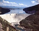 |
| Seli’š Ksanka Qlispe’ Dam (Kerr Dam) | 205 ft (62 m)[170] | 188[171] | Montana | 47°40′38″N 114°14′02″W / 47.67722°N 114.23389°W / 47.67722; -114.23389 (Seli’š Ksanka Qlispe’ Dam) | 1938[169] | Energy Keepers, Inc.[172] | Raised Flathead Lake 10 ft (3.0 m)[169] | 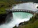 |
Deschutes River dams
Dams are listed in order from headwater (Little Lava Lake, OR) to mouth (Columbia River, WA/OR).
| Name | Height | Capacity (MW) | Province/State(s) | Coordinates | Year of completion | Owner | Reservoir formed | Image |
|---|---|---|---|---|---|---|---|---|
| Crane Prairie Dam | 36 ft (11 m)[173] | 0 | Oregon | 43°45′18″N 121°47′6″W / 43.75500°N 121.78500°W / 43.75500; -121.78500 (Crane Prairie Dam) | 1940[173] | USBR | Crane Prairie Reservoir |  |
| Wickiup Dam | 100 ft (30 m)[173] | 0 | Oregon | 43°41′43″N 121°42′14″W / 43.69528°N 121.70389°W / 43.69528; -121.70389 (Wickiup Dam) | 1949[173] | USBR | Wickiup Reservoir |  |
| Round Butte Dam[174] | 440 ft (130 m) | 247.12 | Oregon | 44°36′0″N 121°16′12″W / 44.60000°N 121.27000°W / 44.60000; -121.27000 (Round Butte Dam)[175] | 1964 | Portland General Electric Company, Confederated Tribes of the Warm Springs Reservation of Oregon | Lake Billy Chinook |  |
| Pelton Dam[174] | 204 ft (62 m) | 100.8 | Oregon | 44°41′24″N 121°13′48″W / 44.69000°N 121.23000°W / 44.69000; -121.23000 (Pelton Dam)[176] | 1957 | Portland General Electric Company, Confederated Tribes of the Warm Springs Reservation of Oregon | Lake Simtustus | 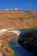 |
| Pelton Reregulating Dam[174] | 88 ft (27 m) | 18.9 | Oregon | 44°43′12″N 121°14′24″W / 44.72000°N 121.24000°W / 44.72000; -121.24000 (Pelton Reregulating Dam)[177] | 1958 | Portland General Electric Company, Confederated Tribes of the Warm Springs Reservation of Oregon |
Yakima River dams
Dams are listed in order from headwater (Keechelus Lake, WA) to mouth (Columbia River, WA).
| Name | Height | Capacity (MW) | Province/State(s) | Coordinates | Year of completion | Owner | Reservoir formed | Image |
|---|---|---|---|---|---|---|---|---|
| Keechelus Dam | 128 ft (39 m)[178] | 0[179] | Washington | 47°19′20″N 121°20′22″W / 47.32222°N 121.33944°W / 47.32222; -121.33944 (Keechelus Dam) | 1917[178] | USBR | Raised Keechelus Lake |  |
| Easton Diversion Dam | 66 ft (20 m)[180] | 0[179] | Washington | 47°14′30″N 121°11′17″W / 47.24167°N 121.18806°W / 47.24167; -121.18806 (Easton Diversion Dam) | 1929[181] | USBR | Lake Easton | 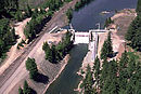 |
| Unnamed Diversion Dam | 0 | Washington | 47°03′50″N 120°39′09″W / 47.06389°N 120.65250°W / 47.06389; -120.65250 (Unnamed Dam) | USBR | ||||
| Roza Diversion Dam | 67 ft (20 m)[182] | 12 | Washington | 46°44′56″N 120°27′56″W / 46.74889°N 120.46556°W / 46.74889; -120.46556 (Roza Dam) | 1939[183] | USBR |  | |
| Wapato Dam | 19 ft (5.8 m)[184] | 0 | Washington | 46°31′27″N 120°28′37″W / 46.52417°N 120.47694°W / 46.52417; -120.47694 (Wapato Dam) | Wapato Reservoir | 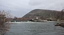 | ||
| Sunnyside Dam | 8 ft (2.4 m)[178] | 0[179] | Washington | 46°29′52″N 120°26′41″W / 46.49778°N 120.44472°W / 46.49778; -120.44472 (Sunnyside Dam) | 1907[185] | Sunnyside Valley Irrigation District | 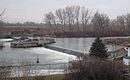 | |
| Prosser Dam | 9 ft (2.7 m)[186] | 0 | Washington | 46°12′45″N 119°46′22″W / 46.21250°N 119.77278°W / 46.21250; -119.77278 (Prosser Dam) | 1904[186] | USBR |  | |
| Wannawish Dam | 6.6 ft (2.0 m)[187] | 0 | Washington | 46°22′43″N 119°25′02″W / 46.37861°N 119.41722°W / 46.37861; -119.41722 (Horn Rapids/Wannawish Dam) | 1892[187] | 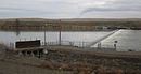 |
Cle Elum River dams
Dams are listed in order from headwaters (near Mount Daniel, WA) to mouth (Yakima River, WA).
| Name | Height | Capacity (MW) | Province/State(s) | Coordinates | Year of completion | Owner | Reservoir formed | Image |
|---|---|---|---|---|---|---|---|---|
| Cle Elum Dam | 165 ft (50 m)[178] | 0[179] | Washington | 47°14′49″N 121°4′23″W / 47.24694°N 121.07306°W / 47.24694; -121.07306 (Cle Elum Dam) | 1933[178] | USBR | Raised Cle Elum Lake |
|

Kachess River dams
Dams are listed in order from headwaters (Three Queens, WA) to mouth (Yakima River, WA).
| Name | Height | Capacity (MW) | Province/State(s) | Coordinates | Year of completion | Owner | Reservoir formed | Image |
|---|---|---|---|---|---|---|---|---|
| Kachess Dam | 115 ft (35 m)[178] | 0[179] | Washington | 47°15′53″N 121°12′9″W / 47.26472°N 121.20250°W / 47.26472; -121.20250 (Kachess Dam) | 1912[178] | USBR | Raised Kachess Lake |  |
Naches River dams
Bumping River dams
Dams are listed in order from headwaters (near Crag Mountain, WA) to mouth (Naches River, WA).
| Name | Height | Capacity (MW) | Province/State(s) | Coordinates | Year of completion | Owner | Reservoir formed | Image |
|---|---|---|---|---|---|---|---|---|
| Bumping Lake Dam | 60 ft (18 m)[178] | 0[179] | Washington | 46°52′16″N 121°17′58″W / 46.87111°N 121.29944°W / 46.87111; -121.29944 (Bumping Lake Dam) | 1910[178] | USBR | Raised Bumping Lake |
|

Tieton River dams
Dams are listed in order from headwaters (Goat Rocks, WA) to mouth (Naches River, WA).
| Name | Height | Capacity (MW) | Province/State(s) | Coordinates | Year of completion | Owner | Reservoir formed | Image |
|---|---|---|---|---|---|---|---|---|
| Clear Creek Dam (North Fork Tieton) | 83 ft (25 m)[178] | 0[179] | Washington | 46°37′40″N 121°16′15″W / 46.62778°N 121.27083°W / 46.62778; -121.27083 (Clear Lake Dam) | 1915[178] | USBR | Clear Lake |
|
| Tieton Dam | 319 ft (97 m)[178] | 0[179] | Washington | 46°39′26″N 121°7′41″W / 46.65722°N 121.12806°W / 46.65722; -121.12806 (Tieton Dam) | 1925[178] | USBR | Rimrock Lake |  |
Willamette River dams
Dams are listed in order from headwaters (Confluence of Middle Fork Willamette River and Coast Fork Willamette River, OR/WA) to mouth (Columbia River, OR)
| Name | Height | Capacity (MW) | Province/State(s) | Coordinates | Year of completion | Owner | Reservoir formed | Image |
|---|---|---|---|---|---|---|---|---|
| Willamette Falls Dam | 20 ft (6.1 m)[188] | 15.18[189] | Oregon | 45°21′11″N 122°37′04″W / 45.35306°N 122.61778°W / 45.35306; -122.61778 (Willamette Falls Dam) | 1888[18] | Portland General Electric |  |
Santiam River dams
Dams are listed in order from headwaters of each fork (North Santiam and South Santiam rivers) to their mouth at the confluence. There are no dams between the confluence and the mouth of the Santiam (Willamette River, OR).
| Name | Height | Capacity (MW) | Province/State(s) | Coordinates | Year of completion | Owner | Reservoir formed | Image |
|---|---|---|---|---|---|---|---|---|
| North Santiam | ||||||||
| Detroit Dam[190] | 463 ft (141 m) | 100 | Oregon | 44°43′18″N 122°15′01″W / 44.72167°N 122.25028°W / 44.72167; -122.25028 (Detroit Dam) | 1953 | Army Corps of Engineers | Detroit Reservoir | 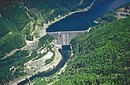 |
| Big Cliff Dam[190] | 191 ft (58 m) | 18 | Oregon | 44°45′03″N 122°16′59″W / 44.75083°N 122.28306°W / 44.75083; -122.28306 (Big Cliff Dam) | 1953 | Army Corps of Engineers | Big Cliff Reservoir (reregulation for Detroit Reservoir) |  |
| South Santiam | ||||||||
| Green Peter Dam[191] | 327 ft (100 m) | 80 | Oregon | 44°27′00″N 122°32′57″W / 44.45000°N 122.54917°W / 44.45000; -122.54917 (Green Peter Dam) | 1968 | Army Corps of Engineers | Green Peter Reservoir |
|
| Foster Dam[191] | 126 ft (38 m) | 20 | Oregon | 44°24′55″N 122°40′13″W / 44.41528°N 122.67028°W / 44.41528; -122.67028 (Foster Dam) | 1968 | Army Corps of Engineers | Foster Reservoir (reregulation for Green Peter Reservoir) |  |

Dams are listed in order from headwater (Timpanogas Lake, OR) to mouth (Willamette River, OR).
| Name | Height | Capacity (MW) | Province/State(s) | Coordinates | Year of completion | Owner | Reservoir formed | Image |
|---|---|---|---|---|---|---|---|---|
| Hills Creek Dam | 304 ft (93 m)[192] | 30[192] | Oregon | 43°42′33″N 122°25′26″W / 43.70917°N 122.42389°W / 43.70917; -122.42389 (Hills Creek Dam) | 1961[192] | USACE | Hills Creek Reservoir |  |
| Lookout Point Dam | 276 ft (84 m)[193] | 150[193] | Oregon | 43°54′48″N 122°45′09″W / 43.91333°N 122.75250°W / 43.91333; -122.75250 (Lookout Point Dam) | 1954[193] | USACE | Lookout Point Lake |  |
| Fall Creek Dam[194] | 180 ft (55 m) | 0 | Oregon | 43°54′49″N 122°45′25″W / 43.91361°N 122.75694°W / 43.91361; -122.75694 (Fall Creek Dam) | 1966 | USACE | Fall Creek Reservoir | |
| Dexter Dam | 93 ft (28 m)[193] | 15[193] | Oregon | 43°55′22″N 122°48′23″W / 43.92278°N 122.80639°W / 43.92278; -122.80639 (Dexter Dam) | 1954[193] | USACE | Dexter Reservoir | 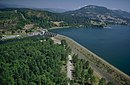 |
McKenzie River dams
Dams are listed in order from headwater (Clear Lake, OR) to mouth (Willamette River, OR).
| Name | Height | Capacity (MW) | Province/State(s) | Coordinates | Year of completion | Owner | Reservoir formed | Image |
|---|---|---|---|---|---|---|---|---|
| Carmen Diversion Dam | 17 ft (5.2 m)[195] | 0[196] | Oregon | 44°20′19″N 122°00′11″W / 44.33861°N 122.00306°W / 44.33861; -122.00306 (Carmen Diversion Dam) | 1963[197] | Eugene Water & Electric Board | Carmen Reservoir | |
| Trail Bridge Dam | 90 ft (27 m)[198] | 10[196] | Oregon | 44°16′24″N 122°03′02″W / 44.27333°N 122.05056°W / 44.27333; -122.05056 (Trail Bridge Dam) | 1963[197] | Eugene Water & Electric Board | Trail Bridge Reservoir | |
| Smith Dam (Smith River) | 250 ft (76 m)[199] | 104.5[196] | Oregon | 44°0′0″N 122°06′36″W / 44.00000°N 122.11000°W / 44.00000; -122.11000 (Smith Dam)[199] | 1963[197] | Eugene Water & Electric Board | Smith Reservoir | |
| Cougar Dam (South Fork)[200] | 425 ft (130 m) | 25 | Oregon | 44°07′44″N 122°14′30″W / 44.12889°N 122.24167°W / 44.12889; -122.24167 (Cougar Dam) | 1963 | Army Corps of Engineers | Cougar Reservoir |  |
| Blue River Dam (Blue River)[200] | 270 ft (82 m) | 0 | Oregon | 44°10′23″N 122°19′47″W / 44.17306°N 122.32972°W / 44.17306; -122.32972 (Blue River Dam) | 1969 | Army Corps of Engineers | Blue River Reservoir |  |
| Leaburg Dam | 20 ft (6.1 m)[201] | 15.9[202] | Oregon | 44°08′15″N 122°36′43″W / 44.13750°N 122.61194°W / 44.13750; -122.61194 (Leaburg Dam)[201] | 1929[202] | Eugene Water & Electric Board | Leaburg Reservoir |  |
| Walterville Dam | 24 ft (7.3 m)[203] | 9[202] | Oregon | 44°03′36″N 122°49′48″W / 44.06000°N 122.83000°W / 44.06000; -122.83000 (Walterville Dam)[203] | 1911[202] | Eugene Water & Electric Board | Walterville Reservoir |
Dams are listed in order from headwater (Confluence of Big River and Garoutte Creek, OR) to mouth (Willamette River).
| Name | Height | Capacity (MW) | Province/State(s) | Coordinates | Year of completion | Owner | Reservoir formed | Image |
|---|---|---|---|---|---|---|---|---|
| Cottage Grove Dam | 95 ft (29 m)[204] | 0 | Oregon | 43°42′58″N 123°03′03″W / 43.71611°N 123.05083°W / 43.71611; -123.05083 (Cottage Grove Dam) | 1942[204] | USACE | Cottage Grove Lake | 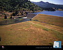 |
| Dorena Dam (Row River) | 145 ft (44 m)[204] | 7.51[205] | Oregon | 43°46′48″N 122°57′0″W / 43.78000°N 122.95000°W / 43.78000; -122.95000 (Dorena Dam) | 1949[204] | USACE | Dorena Lake |
Spokane River dams
Dams are listed in order from headwater (Lake Coeur d'Alene, ID) to mouth (Columbia River, WA).
| Name | Height | Capacity (MW) | Province/State(s) | Coordinates | Year of completion | Owner | Reservoir formed | Image |
|---|---|---|---|---|---|---|---|---|
| Post Falls Dam | 64 ft (20 m)[206] | 15[206] | Idaho | 47°42′31″N 116°57′13″W / 47.70861°N 116.95361°W / 47.70861; -116.95361 (Post Falls Hyrdoelectric Development) | 1908[206] | Avista | Raised Lake Coeur d'Alene |
|
| Upriver Dam | 17.7[207] | Washington | 47°41′09″N 117°19′43″W / 47.68583°N 117.32861°W / 47.68583; -117.32861 (Upright Dam) | 1894 / 1933[n 23] | City of Spokane | Upriver Dam Reservoir |
| |
| Upper Falls Dam | 35 ft (11 m)[208] | 10[208] | Washington | 47°39′46″N 117°24′55″W / 47.66278°N 117.41528°W / 47.66278; -117.41528 (Upper Falls Dam) | 1922[208] | Avista | Upper Falls Reservoir |
|
| Monroe Street Dam | 24 ft (7.3 m)[209] | 15[209] | Washington | 47°39′42″N 117°25′31″W / 47.66167°N 117.42528°W / 47.66167; -117.42528 (Monroe Street Dam) | 1890[209] | Avista |  | |
| Nine Mile Dam | 58 ft (18 m)[210] | 26[210] | Washington | 47°46′30″N 117°32′38″W / 47.77500°N 117.54389°W / 47.77500; -117.54389 (Nine Mile Dam) | 1908[210] | Avista | Nine Mile Reservoir |  |
| Long Lake Dam | 213 ft (65 m)[211] | 71[211] | Washington | 47°50′14″N 117°50′23″W / 47.83722°N 117.83972°W / 47.83722; -117.83972 (Long Lake Dam) | 1915[211] | Avista | Long Lake | 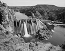 |
| Little Falls Dam | 57 ft (17 m)[212] | 36[213] | Washington | 47°49′57″N 117°55′04″W / 47.83250°N 117.91778°W / 47.83250; -117.91778 (Little Falls Dam) | 1911[214] | Avista | Little Falls Pool |  |


Cowlitz River dams
Dams are listed in order from headwater (confluence of the Ohanapecosh River and the Clear Fork of the Cowlitz River, WA) to mouth (Columbia River, WA)
| Name | Height | Capacity (MW) | Province/State(s) | Coordinates | Year of completion | Owner | Reservoir formed | Image= |
|---|---|---|---|---|---|---|---|---|
| Cowlitz Falls Dam | 140 ft (43 m)[215] | 70[216] | Washington | 46°27′59″N 122°06′33″W / 46.46639°N 122.10917°W / 46.46639; -122.10917 (Cowlitz Falls Dam) | 1994[216] | Lewis County Public Utility District | Lake Scanewa |
|
| Mossyrock Dam | 606 ft (185 m)[217] | 300[217] | Washington | 46°32′04″N 122°25′29″W / 46.53444°N 122.42472°W / 46.53444; -122.42472 (Mossyrock Dam) | 1968[217] | Tacoma Public Utilities | Riffe Lake |  |
| Mayfield Dam | 250 ft (76 m)[218] | 162[218] | Washington | 46°30′10″N 122°35′18″W / 46.50278°N 122.58833°W / 46.50278; -122.58833 (Mayfield Dam) | 1963[218] | Tacoma Public Utilities | Lake Mayfield |  |

Lewis River dams
Dams are listed in order from headwater (Adams Glacier, Mount Adams, WA) to mouth (Columbia River, WA)
| Name | Height | Capacity (MW) | Province/State(s) | Coordinates | Year of completion | Owner | Reservoir formed | Image |
|---|---|---|---|---|---|---|---|---|
| Swift Dam[219] | 512 ft (156 m) | 240 | Washington | 46°04′48″N 122°12′36″W / 46.08000°N 122.21000°W / 46.08000; -122.21000 (Swift Dam)[220] | 1958 | PacifiCorp | Swift Reservoir | |
| Swift No. 2 Dam[219] | 83 ft (25 m)[221] | 70 | Washington | 46°03′46″N 122°11′52″W / 46.06278°N 122.19778°W / 46.06278; -122.19778 (Swift No. 2 Dam)[221] | 1959[221] | Public Utility District No. 1 of Cowlitz County | ||
| Yale Dam[219] | 323 ft (98 m) | 134 | Washington | 45°58′48″N 122°20′24″W / 45.98000°N 122.34000°W / 45.98000; -122.34000 (Yale Dam)[222] | 1953 | PacifiCorp | Yale Lake |
|
| Merwin Dam[219] | 313 ft (95 m) | 136 | Washington | 45°59′24″N 122°28′48″W / 45.99000°N 122.48000°W / 45.99000; -122.48000 (Merwin Dam)[223] | 1931 | PacifiCorp | Lake Merwin |

Spillimacheen River dams
Dams are listed in order from headwater (Canadian Rockies) to mouth (Columbia River, BC).
| Name | Height | Capacity (MW) | Province/State(s) | Coordinates | Year of completion | Owner | Reservoir formed | Image |
|---|---|---|---|---|---|---|---|---|
| Spillimacheen Dam[224] | 14.5 m (48 ft) | 4 | British Columbia | 50°53′56″N 116°25′28″W / 50.89889°N 116.42444°W / 50.89889; -116.42444 (Spillimacheen Dam) | 1955[225] | BC Hydro | Spillimacheen Dam Pool |
Wenatchee River dams
Dams are listed in order from headwater (Lake Wenatchee, WA) to mouth (Columbia River, WA)
| Name | Height | Capacity (MW) | Province/State(s) | Coordinates | Year of completion | Owner | Reservoir formed | Image |
|---|---|---|---|---|---|---|---|---|
| Tumwater Canyon Dam[226] | 23 ft (7.0 m) | 0 | Washington | 47°36′59″N 120°43′22″W / 47.61639°N 120.72278°W / 47.61639; -120.72278 (Tumwater Canyon Dam) | 1909 | Chelan County Public Utility District | Lake Jolanda |
Chelan River dams
Dams are listed in order from headwater (Lake Chelan, WA) to mouth (Columbia River, WA)
| Name | Height | Capacity (MW) | Province/State(s) | Coordinates | Year of completion | Owner | Reservoir formed | Image |
|---|---|---|---|---|---|---|---|---|
| Lake Chelan Dam | 40 ft (12 m)[227] | 59.2[227] | Washington | 47°50′04″N 120°00′45″W / 47.83444°N 120.01250°W / 47.83444; -120.01250 (Lake Chelan Dam) | 1892–1903 / 1927[n 24] | Chelan County Public Utility District | Raised Lake Chelan |  |
See also
 United States portal
 Canada portal
 Water portal
 Renewable energy portal


- List of lakes in Washington (state)
- List of tallest dams in the world
- Dams in the Colorado River system
- List of reservoirs and dams in the United States
- Columbia River Treaty (US–Canadian treaty regulating hydroelectric development)
Notes
- ^ Dam was initially completed in 1941; third power plant was begun in 1967 and completed in 1974.[9]
- ^ Dam was initially completed in 1937; second powerhouse was completed in 1981
- ^ The original dam was completed in 1911. In 1917, the dam was raised 17.5 feet (5.3 m) to increase storage. Later, safety concerns were addressed and the new, modified dam was completed in 1989.[28]
- ^ Original dam was completed in 1927. Due to deterioration, a replacement dam was commissioned and completed in 1978.[31]
- ^ a b c d e Information received in email exchange with representative from Idaho Power.
- ^ Initially completed in 1935, updated in 1995 with diversion structure and two powerhouses[35]
- ^ Constructed with two power plants - A & B. Upper Salmon A was completed in 1937, Upper Salmon B, located a mile upriver from A, was completed in 1947.[35]
- ^ Initially constructed by Greater Shoshone and Twin Falls Water Power Company in 1910, bought by Idaho Power in 1916 and updated in 1949.[35]
- ^ A new power plant was built in the 1990s; this one was decommissioned and turned into a historical display[41][42]
- ^ Dam and units one to four completed in 1959, unit five completed in 1980.[44]
- ^ Dam and first three powerhouses were completed in 1975. Three further powerhouses, as well as modifications to Lewiston's water intake, were completed in 1987.[51]
- ^ Dam was initially completed in 1961 with three generators online. Powerhouse units four through six were later added and online in 1976.[56]
- ^ The first Wild Horse Dam was constructed in 1937. After the aggregate was found to be of poor quality, a new concrete, thin arch dam was completed in 1969, doubling the size of the reservoir.[62]
- ^ Power plant located at Owyhee Dam.[65]
- ^ Power plant located along the Owyhee Tunnel No. 1.[65]
- ^ Power plant located along the Mitchell Butte Lateral.[65]
- ^ Kootenay Canal Generating Station is located at the end of a canal created by the Corra Linn Dam.
- ^ a b Original dam constructed in 1944 created 140 MW; expansion completed in 2007 added 120 MW.[8]
- ^ Although these rivers are not one, for the simplification of this list they will be listed together, as they are only separated by Lake Pend Oreille.
- ^ This dam is made up of four sections with the highest being 110 ft (34 m) and the other three lower sections being 53 ft (16 m),[151] 38 ft (12 m),[152] and 54 ft (16 m).[153]
- ^ All forks of Flathead River are treated as being on main stem, as there is only one dam on any of the forks.
- ^ On South Fork of Flathead River
- ^ Originally constructed in 1894, upgraded to concrete structure in 1933, with significant upgrades in the 1980s.[207]
- ^ Beginning in 1892, dams were constructed at the mouth of Lake Chelan. After two failures, a more robust dam was constructed in 1903, providing electricity to Chelan. The current dam was completed in 1927.[227]
References
- ^ U.S. Energy Information Administration (November 14, 2014). "Renewable Energy Explained". Retrieved January 3, 2015.
- ^ Idaho Transportation Department (2005). "Inside the Idaho Transportation Department" (PDF). Archived from the original (PDF) on February 5, 2012. Retrieved January 3, 2015.
- ^ U.S. Department of Energy (1994). "A Review of the Effects of Dams on the Columbia River Estuarine Environment, with Special Reference to Salmonids" (PDF). Retrieved January 3, 2015.
- ^ Center for the Columbia River History. "Dams of the Columbia Basin & Their Effects on the Native Fishery". Archived from the original on September 15, 2015. Retrieved January 3, 2015.
- ^ a b BC Hydro (2014). "Columbia Region". Archived from the original on January 4, 2015. Retrieved January 3, 2015.
- ^ Ministry of Energy, Mines and Natural Gas (December 5, 2012). "A Review of the Range of Impacts and Benefits of the Columbia River Treaty on Basin Communities, the Region and the Province" (PDF). Retrieved January 3, 2015.
- ^ BC Hydro (2014). "Hugh Keenleyside Dam". Retrieved January 3, 2015.
- ^ a b c d e f g h i j Columbia Basin Trust (2012). "Columbia River Basin: Dams and Hydroelectricity" (PDF). Archived from the original (PDF) on March 22, 2015. Retrieved January 3, 2015.
- ^ a b c United States Bureau of Reclamation (2012). "Grand Coulee Dam and Statistics" (PDF). Archived from the original (PDF) on May 9, 2008. Retrieved January 3, 2015.
- ^ Fundamentals of Renewable Energy. "Chief Joseph Dam Hydroelectric Power Plant" (PDF). Archived from the original (PDF) on January 5, 2015. Retrieved January 3, 2015.
- ^ Columbia Basin Research. "Chief Joseph Dam - Hydroelectric Project Information". Retrieved January 3, 2015.
- ^ Federal Energy Regulatory Commission. "Order Issuing New License" (PDF). Retrieved March 18, 2016.
- ^ Columbia Basin Research. "Wells Dam - Hydroelectric Project Information". Retrieved January 3, 2015.
- ^ Federal Energy Regulatory Commission. "Order on Offer of Settlement and Issuing New License" (PDF). Retrieved March 18, 2016.
- ^ Columbia Basin Research. "Rocky Reach Dam - Hydroelectric Project Information". Retrieved January 3, 2015.
- ^ Federal Energy Regulatory Commission. "Order on Remand Issuing License and Approving Settlement Agreement" (PDF). Retrieved March 18, 2016.
- ^ Columbia Basin Research. "Rock Island Dam - Hydroelectric Project Information". Retrieved January 3, 2015.
- ^ a b The Northwest Power and Conservation Council (November 13, 2013). "A Guide to Major Hydropower Dams of the Columbia River Basin". Retrieved January 6, 2015.
- ^ a b Grant PUD (2015). "WANAPUM DAM". Retrieved January 3, 2015.
- ^ Grant PUD (2015). "PRIEST RAPIDS DAM". Retrieved January 3, 2015.
- ^ Columbia Basin Research. "Priest Rapids Dam - Hydroelectric Project Information". Retrieved January 3, 2015.
- ^ United States Army Corps of Engineers. "McNary Lock and Dam". Retrieved January 3, 2015.
- ^ Columbia Basin Research. "McNary Dam - Hydroelectric Project Information". Retrieved January 3, 2015.
- ^ Columbia Basin Research. "John Day Dam - Hydroelectric Project Information". Retrieved January 3, 2015.
- ^ Columbia Basin Research. "The Dalles Dam - Hydroelectric Project Information". Retrieved January 3, 2015.
- ^ United States Corps of Engineers. "The Bonneville Lock and Dam Fact Sheet" (PDF). Retrieved January 3, 2015.
- ^ Columbia Basin Research. "Bonneville Dam - Hydroelectric Project Information". Retrieved January 3, 2015.
- ^ a b United States Bureau of Reclamation (October 29, 2012). "Jackson Lake Dam". Retrieved January 3, 2015.
- ^ a b United States Bureau of Reclamation (October 25, 2012). "Palisades Dam". Retrieved January 3, 2015.
- ^ Idaho Falls Power. "Idaho Falls Power Hydroelectric Project". Archived from the original on January 1, 2015. Retrieved January 3, 2015.
- ^ a b United States Bureau of Reclamation (October 25, 2012). "American Falls Dam". Retrieved January 3, 2015.
- ^ a b c d e United States Bureau of Reclamation (January 3, 2013). "Minidoka Project". Archived from the original on September 25, 2012. Retrieved March 8, 2016.
- ^ a b c United States Bureau of Reclamation (November 26, 2012). "Minidoka Dam". Retrieved January 3, 2015.
- ^ Idaho State Historical Society Reference Series (1985). "Milner Dam" (PDF). Retrieved January 3, 2015.
- ^ a b c d e f g Idaho Power. "Decision Support Systems" (PDF). Retrieved January 3, 2015.
- ^ Idaho Power. "Hydroelectric Plants". Retrieved January 5, 2015.
- ^ "The History of Shoshone Falls Dam". July 10, 2011. Retrieved January 5, 2015.
- ^ a b Idaho Power (August 2005). "Initial Consultation Document: Shoshone Falls Hydroelectric Project" (PDF). Retrieved January 5, 2015.
- ^ a b Hydropower Reform Coalition & River Management Society (April 2013). "Hydropower Project Summary - Mid-Snake River, Idaho" (PDF). Retrieved January 5, 2015.
- ^ a b Idaho Power. "C. J. Strike Project". Retrieved January 3, 2015.
- ^ Idaho Power. "Swan Falls Power Plant" (PDF). Retrieved March 13, 2016.
- ^ Idaho Power. "Swan Falls". Retrieved January 3, 2015.
- ^ Idaho Power. "Decision Support Systems" (PDF). Retrieved January 3, 2015.
- ^ a b Columbia Basin Research. "Brownlee Dam - Hydroelectric Project Information". Retrieved January 3, 2015.
- ^ Idaho Power. "Decision Support Systems" (PDF). Retrieved January 3, 2015.
- ^ Columbia Basin Research. "Oxbow Dam - Hydroelectric Project Information". Retrieved January 3, 2015.
- ^ Idaho Power. "Decision Support Systems" (PDF). Retrieved January 3, 2015.
- ^ Columbia Basin Research. "Hells Canyon Dam - Hydroelectric Project Information". Retrieved January 3, 2015.
- ^ United States Army Corps of Engineers. "Lower Granite Lock and Dam". Retrieved January 3, 2015.
- ^ Columbia Basin Research. "Lower Granite Dam - Hydroelectric Project Information". Retrieved January 3, 2015.
- ^ United States Corps of Engineers. "Lower Granite Lock and Dam". Retrieved January 3, 2015.
- ^ United States Army Corps of Engineers. "Little Goose Lock and Dam". Retrieved January 3, 2015.
- ^ Columbia Basin Research. "Little Goose Dam - Hydroelectric Project Information". Retrieved January 3, 2015.
- ^ United States Corps of Engineers. "Lower Monumental Lock and Dam". Retrieved January 3, 2015.
- ^ Columbia Basin Research. "Lower Monumental Dam - Hydroelectric Project Information". Retrieved January 3, 2015.
- ^ a b United States Corps of Engineers. "Ice Harbor Lock and Dam". Retrieved January 3, 2015.
- ^ Columbia Basin Research. "Ice Harbor Dam - Hydroelectric Project Information". Retrieved January 3, 2015.
- ^ National Performance of Dams Program (2016). "Goose Creek Dam". Archived from the original on March 13, 2016. Retrieved March 10, 2016.
- ^ National Performance of Dams Program (2016). "Brundage Dam". Archived from the original on March 13, 2016. Retrieved March 10, 2016.
- ^ National Performance of Dams Program (2016). "Wild Horse". Archived from the original on March 13, 2016. Retrieved March 12, 2016.
- ^ State of Nevada (August 26, 2011). "State of Nevada – Certificate of Appropriation of Water" (PDF). Retrieved January 11, 2015.
- ^ U.S. Department of the Interior (1973). "Bathymetric Reconnaissance of Wildhorse Reservoir, Elko County, Nevada" (PDF). Retrieved January 11, 2015.[permanent dead link]
- ^ Department of the Interior - U.S. Fish and Wildlife Service (May 28, 2002). "Report to the Office of Management and Budget on the U.S. Fish and Wildlife Service's Fisheries Mitigation Program" (PDF). Retrieved January 11, 2015.
- ^ National Performance of Dams Program (2016). "Antelope Reservoir (Malheur)". Archived from the original on March 13, 2016. Retrieved March 12, 2016.
- ^ a b c d e United States Bureau of Reclamation (January 3, 2013). "Owyhee Project". Retrieved March 12, 2016.
- ^ National Performance of Dams Program (2016). "Wilson Res". Archived from the original on March 13, 2016. Retrieved March 10, 2016.
- ^ National Performance of Dams Program (2016). "Bull Run Dam". Archived from the original on March 13, 2016. Retrieved March 10, 2016.
- ^ National Performance of Dams Program (2016). "Dry Creek Dam". Archived from the original on March 13, 2016. Retrieved March 10, 2016.
- ^ National Performance of Dams Program (2016). "Rawhide Res". Archived from the original on March 13, 2016. Retrieved March 10, 2016.
- ^ National Performance of Dams Program (2016). "Sheep Creek Reservoir". Archived from the original on March 13, 2016. Retrieved March 10, 2016.
- ^ National Performance of Dams Program (2016). "Chimney Creek Dam". Archived from the original on March 13, 2016. Retrieved March 10, 2016.
- ^ National Performance of Dams Program (2016). "Warm Springs". Archived from the original on March 13, 2016. Retrieved March 12, 2016.
- ^ a b c d e United States Bureau of Reclamation (June 1, 2012). "Vale Project". Retrieved March 12, 2016.
- ^ Oregon Fish and Wildlife Commission (January 1, 2014). "Agreement between Warmsprings Irrigation District and the Oregon Fish and Wildlife Commission Concerning Funding of a Fish Entrainment Mitigation Program in Lieu of Fish Screens for the Warmsprings Dam Hydroelectric Project, FERC Number 13570 (Agreement)" (PDF). Retrieved March 12, 2016.
- ^ National Performance of Dams Program (2016). "Warm Springs". Archived from the original on March 13, 2016. Retrieved March 12, 2016.
- ^ Federal Energy Regulatory Commission (May 2, 2009). "Agency Valley Hydro, LLC; Notice of Application Accepted for Filing and Soliciting Motions To Intervene, Protests, and Comments" (PDF). Retrieved March 12, 2016.
- ^ National Performance of Dams Program (2016). "Bully Creek". Archived from the original on March 13, 2016. Retrieved March 12, 2016.
- ^ National Performance of Dams Program (2016). "Willow Creek Reservoir #3 (Malheur)". Archived from the original on March 13, 2016. Retrieved March 12, 2016.
- ^ National Performance of Dams Program (2016). "Wallowa Lake Reservoir". Archived from the original on March 13, 2016. Retrieved March 12, 2016.
- ^ National Performance of Dams Program (2016). "Mason". Archived from the original on March 13, 2016. Retrieved March 12, 2016.
- ^ a b United States Bureau of Reclamation (June 1, 2012). "Baker Project". Retrieved March 12, 2016.
- ^ Federal Energy Regulatory Commission (August 11, 2014). "Notice of Application Accepted for Filing, Soliciting Motions to Intervene and Protests, Ready for Environmental Analysis, and Soliciting Comments, Recommendations, Preliminary Terms and Conditions, and Preliminary Fishway Prescriptions". Retrieved March 12, 2016.
- ^ National Performance of Dams Program (2016). "Thief Valley". Archived from the original on March 13, 2016. Retrieved March 12, 2016.
- ^ United States Bureau of Land Management (March 19, 2014). "Blackfoot Reservoir Campground". Archived from the original on March 11, 2016. Retrieved March 10, 2016.
- ^ a b c National Performance of Dams Program (2016). "Blackfoot". Archived from the original on March 11, 2016. Retrieved March 10, 2016.
- ^ a b c d National Performance of Dams Program (2016). "Henry's Lake". Archived from the original on March 9, 2016. Retrieved March 8, 2016.
- ^ a b c National Performance of Dams Program (2016). "Island Park". Archived from the original on March 9, 2016. Retrieved March 8, 2016.
- ^ Northwest Power Services, Inc. (April 2006). "Buffalo River Hydroelectric Project: Report Supporting Endorsement as a Low-Impact Hydroelectric Power Facility" (PDF). Retrieved March 9, 2016.
- ^ Low Impacy Hydropower Institute (November 8, 2015). "LIHI Certificate #61 – Ashton Hydroelectric Project, Idaho". Retrieved March 9, 2016.
- ^ a b National Performance of Dams Program (2015). "Ashton". Archived from the original on March 10, 2016. Retrieved March 9, 2016.
- ^ National Performance of Dams Program (2015). "Crosscut Diversion". Archived from the original on March 10, 2016. Retrieved March 9, 2016.
- ^ Sunrise Engineering (May 2011). "Chester Hydroelectric Project". Retrieved March 9, 2016.
- ^ a b National Performance of Dams Program (2016). "Grassy Lake". Archived from the original on March 11, 2016. Retrieved March 10, 2016.
- ^ National Performance of Dams Program (2016). "Portneuf". Archived from the original on March 11, 2016. Retrieved March 10, 2016.
- ^ National Performance of Dams Program (2016). "Salmon Falls". Archived from the original on March 11, 2016. Retrieved March 10, 2016.
- ^ National Performance of Dams Program (2016). "Cedar Creek". Archived from the original on March 11, 2016. Retrieved March 10, 2016.
- ^ National Performance of Dams Program (2016). "Arrowrock". Archived from the original on March 13, 2016. Retrieved March 10, 2016.
- ^ a b c d e f United States Bureau of Reclamation (January 3, 2013). "Boise Project". Retrieved March 12, 2016.
- ^ National Performance of Dams Program (2016). "Lucky Peak". Archived from the original on March 13, 2016. Retrieved March 10, 2016.
- ^ United States Army Corps of Engineers (2012). "Lucky Peak Dam and Lake". Retrieved March 12, 2016.
- ^ National Performance of Dams Program (2016). "Boise River Diversion". Archived from the original on March 13, 2016. Retrieved March 10, 2016.
- ^ National Performance of Dams Program (2016). "Barber". Archived from the original on March 13, 2016. Retrieved March 10, 2016.
- ^ Enel Green Power (2015). "Barber Dam Hydroelectric Project". Archived from the original on March 4, 2016. Retrieved March 12, 2016.
- ^ National Performance of Dams Program (2016). "Anderson Ranch". Archived from the original on March 13, 2016. Retrieved March 10, 2016.
- ^ National Performance of Dams Program (2016). "Little Camas". Archived from the original on March 13, 2016. Retrieved March 10, 2016.
- ^ National Performance of Dams Program (2016). "Oakley". Archived from the original on March 12, 2016. Retrieved March 11, 2016.
- ^ National Performance of Dams Program (2016). "Lost Valley". Archived from the original on March 13, 2016. Retrieved March 11, 2016.
- ^ National Performance of Dams Program (2016). "C Ben Ross". Archived from the original on March 13, 2016. Retrieved March 11, 2016.
- ^ National Performance of Dams Program (2016). "Crane Creek". Archived from the original on March 13, 2016. Retrieved March 11, 2016.
- ^ National Performance of Dams Program (2016). "Mann Creek". Archived from the original on March 13, 2016. Retrieved March 11, 2016.
- ^ United States Bureau of Reclamation (January 3, 2013). "Mann Creek Project". Retrieved March 12, 2016.
- ^ National Performance of Dams Program (2016). "Unity". Archived from the original on March 13, 2016. Retrieved March 12, 2016.
- ^ United States Bureau of Reclamation (June 1, 2012). "Burnt River Project". Retrieved March 12, 2016.
- ^ United States Bureau of Reclamation (June 1, 2012). "Bureau of Reclamation Renewable Energy Update" (PDF). Retrieved March 12, 2016.
- ^ United States Bureau of Reclamation (July 12, 2012). "Ririe Project". Retrieved March 10, 2016.
- ^ a b c National Performance of Dams Program (2016). "Ririe". Archived from the original on March 11, 2016. Retrieved March 10, 2016.
- ^ National Performance of Dams Program (2016). "Black Canyon Diversion". Archived from the original on March 13, 2016. Retrieved March 10, 2016.
- ^ National Performance of Dams Program (2016). "Upper Payette Lake". Archived from the original on March 13, 2016. Retrieved March 10, 2016.
- ^ National Performance of Dams Program (2016). "Granite Lake Dam". Archived from the original on March 13, 2016. Retrieved March 10, 2016.
- ^ National Performance of Dams Program (2016). "Payette Lake". Archived from the original on March 13, 2016. Retrieved March 10, 2016.
- ^ National Performance of Dams Program (2016). "Little Payette Lake". Archived from the original on March 13, 2016. Retrieved March 10, 2016.
- ^ National Performance of Dams Program (2016). "Cascade". Archived from the original on March 13, 2016. Retrieved March 10, 2016.
- ^ National Performance of Dams Program (2016). "Sage Hen". Archived from the original on March 13, 2016. Retrieved March 10, 2016.
- ^ National Performance of Dams Program (2016). "Paddock Valley". Archived from the original on March 13, 2016. Retrieved March 10, 2016.
- ^ National Performance of Dams Program (2016). "Deadwood". Archived from the original on March 13, 2016. Retrieved March 10, 2016.
- ^ "Dworshak Dam and Reservoir". U.S. Army Corps of Engineers. Retrieved September 9, 2015.
- ^ a b "Swan Falls Settlement – Hydro Project Data Summary" (PDF). Idaho Department of Water Resources. June 11, 2009.
- ^ a b c d "Hydroelectric Plants".
- ^ a b c d National Performance of Dams Program (2016). "Magic". Archived from the original on March 12, 2016. Retrieved March 11, 2016.
- ^ Foundation for Water and Energy Education (2016). "Magic Dam: Big Wood River, ID". Retrieved March 11, 2016.
- ^ National Performance of Dams Program (2016). "Mormon (Twin Lakes)". Archived from the original on March 13, 2016. Retrieved March 12, 2016.
- ^ a b c d National Performance of Dams Program (2016). "Little Wood". Archived from the original on March 12, 2016. Retrieved March 11, 2016.
- ^ United States Bureau of Reclamation (July 26, 2012). "Little Wood River Project". Retrieved March 11, 2016.
- ^ a b c d National Performance of Dams Program (2016). "Fish Creek". Archived from the original on March 12, 2016. Retrieved March 11, 2016.
- ^ United States Army Corps of Engineers (May 24, 2013). "Libby Dam Visitor Center hours and tours reduced for Summer 2013". Archived from the original on January 8, 2015. Retrieved January 6, 2015.
- ^ United States Army Corps of Engineers. "Libby Dam and Lake Koocanusa". Retrieved January 6, 2015.
- ^ USACE & Bonneville Power Administration (February 2009). "Columbia River Treaty: History and 2014/2024 Review" (PDF). Archived from the original (PDF) on September 2, 2014. Retrieved January 6, 2015.
- ^ a b c FortisBC. "Electricity facilities & operations". Retrieved January 6, 2015.
- ^ Touchstone Nelson: Museum of Art and History (2007). "Upper Bonnington Dam". Archived from the original on September 26, 2018. Retrieved January 6, 2015.
- ^ Touchstone Nelson: Museum of Art and History (2007). "Lower Bonnington Dam". Archived from the original on September 26, 2018. Retrieved January 6, 2015.
- ^ Touchstones Nelson:Museum of Art and History (2007). "South Slocan Dam". Retrieved January 7, 2015.
- ^ Waymarking (June 10, 2013). "Kootenay Canal Dam - Bonnington Falls, BC". Retrieved January 7, 2015.
- ^ Touchstone Nelson: Museum of Art and History (2007). "Brilliant Dam". Archived from the original on September 26, 2018. Retrieved January 7, 2015.
- ^ Virtual Museum Canada (2007). "Aberfeldie Dam". Retrieved September 22, 2017.
- ^ BC Hydro (June 11, 2009). "BC Hydro completes new Aberfeldie Generating Station". Retrieved September 22, 2017.
- ^ Virtual Museum Canada (2007). "Elko Dam". Retrieved September 22, 2017.
- ^ "Elko Project Water Use Plan" (PDF). BC Hydro. 2009. Retrieved September 22, 2017.
- ^ United States Army Corps of Engineers (May 24, 2013). "Duncan Dam". Retrieved September 22, 2017.
- ^ Northwest Hydraulic Consultants (December 6, 2015). "Mark Creek Dam(D310002-00)2015 Dam Safety Review". Retrieved September 22, 2017.
- ^ National Performance of Dams Program (2016). "Thompson Falls - Intake Dam B". Retrieved March 13, 2016.[permanent dead link]
- ^ a b National Performance of Dams Program (2016). "Thompson Falls - Intake Dam A". Retrieved March 13, 2016.[permanent dead link]
- ^ National Performance of Dams Program (2016). "Thompson Falls - Dry Channel Dam". Retrieved March 13, 2016.[permanent dead link]
- ^ National Performance of Dams Program (2016). "Thompson Falls - Main Channel Dam". Retrieved March 13, 2016.[permanent dead link]
- ^ Northwestern Energy (October 2014). "Once-in-a-Lifetime Opportunity for Montana: PPL Hydro Acquisition" (PDF). Retrieved March 13, 2016.
- ^ a b c d e f Kalispel Natural Resource Department (March 9, 2014). "Yes, It's Happening…..Fish Passage on 6 Dams in the Pend Oreille & Clark Fork Rivers for Resident Fish" (PDF). Retrieved January 9, 2015.
- ^ Avista Corporation (October 31, 2007). "Application of Avista Corp" (PDF). Retrieved January 9, 2015.
- ^ Montana Department of Fish, Wildlife and Parks (April 1985). "Wildlife and Wildlife Habitat Mitigation Plan for the Nixon Rapids and Cabinet Gorge Hydroelectric Projects". Retrieved January 9, 2015.
- ^ Idaho Public Television. "Cabinet Gorge Dam". Archived from the original on May 19, 2016. Retrieved January 9, 2015.
- ^ a b The Office of the Governor (November 12, 2012). "60th Anniversary of Cabinet Gorge Dam" (PDF). Archived from the original (PDF) on January 10, 2015. Retrieved January 9, 2015.
- ^ United States Army Corps of Engineers (October 2011). "Albeni Falls Dam Flexible Winter Power Operations Bonner County, Idaho" (PDF). Retrieved January 9, 2015.
- ^ Pend Oreille Public Utility District. "Box Canyon Hydro". Archived from the original on August 23, 2018. Retrieved March 13, 2016.
- ^ Foundation for Water & Energy Education. "Box Canyon: Pend Oreille River, WA". Retrieved January 9, 2015.
- ^ a b c d United States Corps of Engineers North Pacific Division (November 1995). "Columbia River System Operation Review: Final Environmental Impact Statement" (PDF). Retrieved January 9, 2015.
- ^ Touchstones Nelson: Museum of Art and History (2007). "Seven Mile Dam". Archived from the original on September 26, 2018. Retrieved January 9, 2015.
- ^ "Quick Facts For the Year Ended March 31, 2017" (PDF). BC Hydro. Retrieved April 29, 2018.
- ^ "Waneta Expansion Generating Station | Columbia Power". columbiapower.org. May 10, 2013. Retrieved April 29, 2018.
- ^ United States Bureau of Reclamation (October 13, 2013). "Hungry Horse Dam". Retrieved January 9, 2015.
- ^ United States Bureau of Reclamation (October 21, 2013). "Hungry Horse Powerplant". Archived from the original on November 29, 2014. Retrieved January 9, 2015.
- ^ a b c United States Corps of Engineers North Pacific Division (November 1995). "Columbia River System Operation Review: Final Environmental Impact Statement" (PDF). Retrieved January 9, 2015.
- ^ High Country News (November 25, 2013). "Montana Tribes will be First to own a Hydroelectric Dam". Retrieved January 9, 2015.
- ^ Confederated Salish and Kootenai Tribes of the Flathead Nation. "Acquisition of Kerr Dam & Establishment of Wholesale Power Generation Corporation" (PDF). Retrieved January 9, 2015.
- ^ "Federal commission OKs 2nd new name for former Kerr Dam". November 10, 2015.
- ^ a b c d United States Bureau of Reclamation (January 3, 2013). "Deschutes Project". Retrieved March 1, 2016.
- ^ a b c Low Impact Hydropower Institute (October 1, 2016). "LIHI Certificate #25 – Pelton Round Butte Project, Oregon". Retrieved March 1, 2016.
- ^ National Performance of Dams Program. "Round Butte Dam". Archived from the original on March 7, 2016. Retrieved March 1, 2016.
- ^ National Performance of Dams Program. "Pelton Dam". Archived from the original on March 7, 2016. Retrieved March 1, 2016.
- ^ National Performance of Dams Program. "Pelton Dam". Archived from the original on March 7, 2016. Retrieved March 1, 2016.
- ^ a b c d e f g h i j k l m United States Bureau of Reclamation (January 3, 2013). "Yakima Project". Archived from the original on August 27, 2014. Retrieved January 10, 2015.
- ^ a b c d e f g h Oregon Public Broadcasting (September 13, 2011). "As dams come down, a new look at hydropower". Retrieved January 10, 2015.
- ^ United States Bureau of Reclamation (March 27, 2009). "Easton Diversion Dam - Dimensions". Retrieved January 10, 2015.
- ^ United States Bureau of Reclamation (March 27, 2009). "Easton Diversion Dam - General". Retrieved January 10, 2015.
- ^ United States Bureau of Reclamation (July 9, 2012). "Roza Diversion Dam - Dimensions". Retrieved January 10, 2015.
- ^ United States Bureau of Reclamation (July 9, 2012). "Roza Diversion Dam - General". Retrieved January 10, 2015.
- ^ Department of Ecology (June 1991). "Wapato Dam Hydrologic Analysis" (PDF). Retrieved January 10, 2015.
- ^ Sunnyside Valley Irrigation District. "Facts and Figures: Sunnyside Division" (PDF). Retrieved January 10, 2015.
- ^ a b U.S. Fish and Wildlife Service (2012). "Passage of Radio-Tagged Adult Pacific Lamprey at Yakima River Diversion Dams" (PDF). Retrieved January 10, 2015.
- ^ a b U.S. Fish and Wildlife Service (2012). "Passage of Radio-Tagged Adult Pacific Lamprey at Yakima River Diversion Dams" (PDF). Retrieved January 10, 2015.
- ^ Gabriela Goldfarb Consulting (February 14, 2008). "Final Application Reviewer Report for the Willamette Falls Hydroelectric Project" (PDF). Retrieved January 11, 2015.
- ^ Low Impact Hydropower Institute. "LIHI Certificate #33 – Willamette Falls Hydroelectric Project, Oregon". Archived from the original on April 2, 2016. Retrieved January 11, 2015.
- ^ a b United States Army Corps of Engineers (2009). "Detroit Lake and Big Cliff Lake, Oregon" (PDF). Retrieved March 3, 2016.
- ^ a b United States Army Corps of Engineers (2009). "Green Peter Lake and Foster Lake, Oregon" (PDF). Retrieved March 3, 2016.
- ^ a b c United States Army Corps of Engineers (2009). "Hills Creek Lake, Oregon" (PDF). Retrieved January 11, 2015.
- ^ a b c d e f United States Army Corps of Engineers (2009). "Lookout Point Lake and Dexter Lake, Oregon" (PDF). Archived from the original (PDF) on September 23, 2014. Retrieved January 11, 2015.
- ^ United States Army Corps of Engineers (2009). "Fall Creek Lake, Oregon" (PDF). Retrieved March 3, 2016.
- ^ National Performance of Dams Program. "Carmen Diversion". Archived from the original on March 7, 2016. Retrieved March 3, 2016.
- ^ a b c Eugene Water & Electric Board. "Map of the Project". Archived from the original on March 5, 2016. Retrieved March 3, 2016.
- ^ a b c Eugene Water & Electric Board. "Carmen-Smith Hydroelectric Project". Retrieved March 3, 2016.
- ^ National Performance of Dams Program. "Trail Bridge". Archived from the original on March 7, 2016. Retrieved March 3, 2016.
- ^ a b National Performance of Dams Program. "Smith". Archived from the original on March 7, 2016. Retrieved March 3, 2016.
- ^ a b United States Army Corps of Engineers (2009). "Blue River Lake and Cougar Lake, Oregon" (PDF). Archived from the original (PDF) on February 20, 2013. Retrieved March 3, 2016.
- ^ a b National Performance of Dams Program. "Leaburg". Archived from the original on March 7, 2016. Retrieved March 3, 2016.
- ^ a b c d Eugene Water & Electric Board. "Leaburg-Walterville Hydroelectric Project". Retrieved January 11, 2015.
- ^ a b National Performance of Dams Program. "Walterville Forebay". Archived from the original on March 7, 2016. Retrieved March 3, 2016.
- ^ a b c d United States Army Corps of Engineers (2009). "Cottage Grove Lake and Dorena Lake, Oregon" (PDF). Retrieved January 11, 2015.
- ^ HTE Engineering (2014). "Dorena Lake Dam Hydroelectric Project". Retrieved March 3, 2016.
- ^ a b c Avista. "Post Falls Hydroelectric Development". Retrieved January 11, 2015.
- ^ a b Spokane Public Works and Utilities. "Upriver Dam". Archived from the original on March 19, 2014. Retrieved January 11, 2015.
- ^ a b c Avista. "Upper Falls Hydroelectric Development". Retrieved January 11, 2015.
- ^ a b c Avista. "Monroe Street Hydroelectrical Development". Retrieved January 11, 2015.
- ^ a b c Avista. "Nine Mile Hydroelectric Development". Retrieved January 11, 2015.
- ^ a b c Avista. "Long Lake Hydroelectric Development". Retrieved January 11, 2015.
- ^ Avista Corporation (July 2005). "Spokane River Hydroelectric Project" (PDF). Retrieved January 11, 2015.
- ^ Avista. "Little Falls Discharge". Retrieved January 11, 2015.
- ^ Northwest Council (October 31, 2008). "Spokane River". Retrieved January 11, 2015.
- ^ Lewis County PUD (2013). "Cowlitz Falls Project". Retrieved January 11, 2015.
- ^ a b Moody’s Investor Service (May 30, 2013). "Moody's assigns Aa1 rating to BPA backed Cowlitz Falls Hydro debt" (PDF). Retrieved January 11, 2015.
- ^ a b c Tacoma Public Utilities. "Mossyrock Dam". Retrieved January 11, 2015.
- ^ a b c Tacoma Public Utilities. "Mayfield Dam". Retrieved January 11, 2015.
- ^ a b c d PacifiCorp (2016). "Lewis River". Archived from the original on April 4, 2019. Retrieved March 3, 2016.
- ^ National Performance of Dams Program (2016). "Swift No. 1". Archived from the original on March 7, 2016. Retrieved March 3, 2016.
- ^ a b c National Performance of Dams Program (2016). "Swift No. 2 Hydroelectric Project". Archived from the original on March 7, 2016. Retrieved March 3, 2016.
- ^ National Performance of Dams Program (2016). "Yale". Archived from the original on March 7, 2016. Retrieved March 3, 2016.
- ^ National Performance of Dams Program (2016). "Merwin". Archived from the original on March 7, 2016. Retrieved March 3, 2016.
- ^ BC Hydro (July 15, 2005). "Spillimacheen Project Water Use Plan" (PDF). Retrieved September 22, 2017.
- ^ Virtual Museum Canada (2007). "Spillimacheen Dam". Retrieved September 22, 2017.
- ^ Washington State Department of Transportation (May 2008). "Preliminary Tumwater Canyon Reach Analysis of Wenatchee River and US2, Milepost 94 to 98" (PDF). Archived from the original (PDF) on June 15, 2010. Retrieved March 3, 2016.
- ^ a b c Hydropower Reform Coalition (2009). "Hydropower Reform Coalition Success Story" (PDF). Retrieved January 12, 2015.
External links
- Erik Robinson (April 15, 2007). "Pressure builds on Snake River dams". The Columbian.
- v
- t
- e
states traversed
- British Columbia
- Washington
- Oregon

- Cities
- Crossings
- Dams
- Rapids
- Tributaries
- Geology of the Pacific Northwest
- Columbia River Basalt Group
- Columbia River Gorge
- Missoula Floods
- Bonneville Slide/Bridge of the Gods land bridge
- Columbia Mountains
- Robert Gray exploration
- Lewis and Clark Expedition
- David Thompson
- Pacific Fur Company
- Fort Vancouver
- Steamboats of the Columbia River
- Big Bend Gold Rush
- Steamboats of the Arrow Lakes
- Steamboats of the upper Columbia and Kootenay Rivers
- Columbia River Treaty
- Historic Columbia River Highway
- Columbia Basin Project
- Bonneville Power Administration
- Hanford Site
- Sohappy v. Smith
- Boldt Decision
- Vanport flood of 1948


