List of lighthouses in France
Map all coordinates using OpenStreetMap
Download coordinates as:
- KML
- GPX (all coordinates)
- GPX (primary coordinates)
- GPX (secondary coordinates)
This list is incomplete; you can help by adding missing items. (August 2008) |
This is a list of lighthouses in France. It includes the French overseas territories.
Metropolitan France
| Name | Image | Water body | Département | Location & coordinates | Year built | Notes |
|---|---|---|---|---|---|---|
| Phare du Cap Leucate |  | Gulf of Lion | Aude | Cap Leucate 42°54′5″N 003°03′3″E / 42.90139°N 3.05083°E / 42.90139; 3.05083 | 1950 | |
| Planier Light |  | Gulf of Lion | Bouches-du-Rhône | Île du Planier (Planier island) 43°11′54.83″N 5°13′51.29″E / 43.1985639°N 5.2309139°E / 43.1985639; 5.2309139 | 1959 | The first tower was built in this location in 1320 by Robert d'Anjou. |
| Giraglia |  | Ligurian Sea | Haute-Corse | Giraglia Island, north off Cap Corse | 1848[1] | |
| Héaux de Bréhat Lighthouse |  | Atlantic Ocean | Côtes-d'Armor | Île-de-Bréhat 48°54′30″N 3°5′15″W / 48.90833°N 3.08750°W / 48.90833; -3.08750 | 1840 | |
| Ploumanac'h Lighthouse |  | Atlantic Ocean | Côtes-d'Armor | Perros-Guirec 48°50′15″N 3°29′0″W / 48.83750°N 3.48333°W / 48.83750; -3.48333 | 1946 | An older lighthouse dating from 1860 was destroyed in 1944 and replaced by the current structure. |
| Roches-Douvres Light |  | Atlantic Ocean | Côtes-d'Armor | Roches-Douvre reef between Île-de-Bréhat and Guernsey 49°6′18″N 2°48′50″W / 49.10500°N 2.81389°W / 49.10500; -2.81389 | 1954 | At a height of 213 feet (65 m) it is the eleventh-tallest "traditional lighthouse" in the world.[2] |
| Sept-Îles Lighthouse |  | Atlantic Ocean | Côtes-d'Armor | Perros-Guirec 48°52′43″N 3°29′24″W / 48.87861°N 3.49000°W / 48.87861; -3.49000 | 1854 | The first lighthouse, a round tower, was illuminated in May 1835, and then replaced in 1854 by a square tower 16 ft (5 m) taller. Destroyed 4 August 1944, it was rebuilt in 1949 and relit in July 1952. |
| Triagoz Lighthouse |  | Atlantic Ocean | Côtes-d'Armor | Triagoz archipelago 48°52′17″N 3°38′47″W / 48.87139°N 3.64639°W / 48.87139; -3.64639 | 1864 | |
| Ar Men |  | Atlantic Ocean | Finistère | West of Île de Sein 48°3′0″N 4°59′54″W / 48.05000°N 4.99833°W / 48.05000; -4.99833 | 1881 | |
| Phare d'Eckmühl |  | Atlantic Ocean | Finistère | Penmarc'h 47°47′19.55″N 4°22′22.23″W / 47.7887639°N 4.3728417°W / 47.7887639; -4.3728417 | 1897 | The current tower replaced an older lighthouse constructed in 1835. |
| La Vieille |  | Atlantic Ocean | Finistère | Raz de Sein 48°02′26″N 4°45′23″W / 48.04056°N 4.75639°W / 48.04056; -4.75639 | 1887 | |
| Phare du Créac'h | 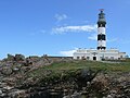 | Atlantic Ocean | Finistère | Ushant island 48°27′34.23″N 5°7′45.4″W / 48.4595083°N 5.129278°W / 48.4595083; -5.129278 | 1863 | |
| Saint-Mathieu Lighthouse | 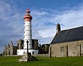 | Atlantic Ocean | Finistère | Pointe Saint-Mathieu 48°19′48″N 4°46′15″W / 48.33000°N 4.77083°W / 48.33000; -4.77083 | 1835 | The lighthouse was classified as a monument historique on 23 May 2011.[3][4] |
| Île Vierge Lighthouse |  | Atlantic Ocean | Finistère | Île Vierge 48°38′19.9″N 4°34′03.0″W / 48.638861°N 4.567500°W / 48.638861; -4.567500 | 1902 | The current tower replaced an older lighthouse from 1845. The island is open to the public from April to September, as is the lighthouse, by appointment.[5] |
| La Jument |  | Atlantic Ocean | Finistère | Off Ushant island 48°25′0″N 5°7′59″W / 48.41667°N 5.13306°W / 48.41667; -5.13306 | 1911 | Jean Guichard's 1989 dramatic storm photo shots of the Jument Lighthouse became an instant hit and earned him the 2nd place in the 1991 World Press Photo award.[6] |
| Petit Minou Lighthouse |  | Atlantic Ocean | Finistère | Roadstead of Brest 48°20′12″N 4°36′51″W / 48.33667°N 4.61417°W / 48.33667; -4.61417 | 1848 | Together with the Phare du Portzic, Petit Minou Lighthouse forms a range of lights into the roadstead.[7] |
| Phare du Portzic | 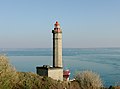 | Atlantic Ocean | Finistère | Roadstead of Brest 48°21′30″N 4°32′03″W / 48.35833°N 4.53417°W / 48.35833; -4.53417 | 1848 | Together with the Petit Minou Lighthouse, Portzic Lighthouse forms a range of lights into the roadstead.[7] |
| Tourelle de la Plate |  | Atlantic Ocean | Finistère | Raz de Sein 48°2′21″N 4°45′35″W / 48.03917°N 4.75972°W / 48.03917; -4.75972 | 1910[7] | |
| Phare de Tévennec | 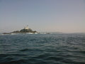 | Atlantic Ocean | Finistère | Raz de Sein | 1875[7] | |
| Phare de Nividic |  | Atlantic Ocean | Finistère | Ouessant 48°26′44″N 5°09′03″W / 48.44556°N 5.15083°W / 48.44556; -5.15083 | 1936 | At a longitude of 5°09.1' W, this is France's westernmost lighthouse.[8] |
| Phare de l'île aux Moutons [de; fr] |  | Atlantic Ocean | Finistère | On an islet 11 kilometres (6.8 mi) southeast of Bénodet | 1879[7] | |
| Phare de l'île Tristan [fr] |  | Atlantic Ocean | Finistère | Tristan Island off Douarnenez | 1865[7] | |
| Phare du Millier [de; fr] |  | Atlantic Ocean | Finistère | On a headland in the southern part of the Baie de Douarnenez[7] | 1881 | |
| Phare des Pierres Noires [br; de; fr; it; lb] | 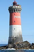 | Atlantic Ocean | Finistère | On an islet 9 kilometres (5.6 mi) west off Pointe Saint-Mathieu[8] | 1872 | |
| Phare de Penfret [br; de; fr] |  | Atlantic Ocean | Finistère | Penfret, Glénan islands[7] | 1837 | |
| Phare de Roscoff [de; fr] |  | Atlantic Ocean | Finistère | Roscoff | 1917[8] | |
| Phare de l'île de Batz [fr] |  | Atlantic Ocean | Finistère | Île de Batz | 1836 | The lighthouse replaced an earlier building from 1705.[8] |
| Phare de Pontusval [br; fr] |  | Atlantic Ocean | Finistère | 2 kilometres (1.2 mi) northwest of Brignogan-Plages[8] | 1869 | |
| Phare du Four |  | Atlantic Ocean | Finistère | At the northern entrance to the Chenal du Four[8] | 1874 | |
| Phare de Kéréon |  | Atlantic Ocean | Finistère | Situated on a rock called Men Tensel NW of Ile de Bannec 48°26'30"N 05°01'46"W | 1916 | The most beautiful[citation needed] lighthouse in France; nicknamed "The Palace" by its Light Keepers. The last manned offshore station in France, automated in 2004. |
| Phare de l'Espiguette |  | Gulf of Lion | Gard | Pointe de l'Espiguette 43°29′16″N 4°8′31″E / 43.48778°N 4.14194°E / 43.48778; 4.14194 | 1869 | |
| Cordouan Lighthouse |  | Bay of Biscay | Gironde | Gironde estuary 45°35′10.84″N 1°10′24.48″W / 45.5863444°N 1.1734667°W / 45.5863444; -1.1734667 | 1611 | The original tower was raised to 68 metres (223 ft) in the late 18th century. |
| Phare de Gatteville | 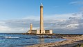 | English Channel | Manche | Barfleur 49°41′47.12″N 1°15′57.29″W / 49.6964222°N 1.2659139°W / 49.6964222; -1.2659139 | 1774 | At a height of 75 metres (246 ft) it is the third tallest "traditional lighthouse" in the world.[2] |
| Goulphar Lighthouse |  | Bay of Biscay | Morbihan | Belle-Île-en-Mer 47°18′40″N 3°13′39″W / 47.31111°N 3.22750°W / 47.31111; -3.22750 | 1836[9] | |
| Phare de La Teignouse [de; fr] |  | Bay of Biscay | Morbihan | Quiberon 47°27′27″N 3°2′45″W / 47.45750°N 3.04583°W / 47.45750; -3.04583 | 1845 | |
| Cap d'Antifer Lighthouse | 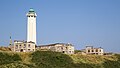 | English Channel | Seine-Maritime | La Poterie-Cap-d'Antifer 49°41′01″N 0°09′55″E / 49.6835°N 0.1654°E / 49.6835; 0.1654 | 1955 | |
| Dunkirk Lighthouse |  | English Channel | Nord | Near Dunkirk 51°02′56″N 02°21′51″E / 51.04889°N 2.36417°E / 51.04889; 2.36417 | 1843 | |
| Phare de Sainte Marie | 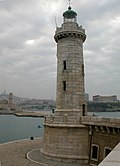 | Gulf of Lion | Provence-Alpes-Côte d'Azur | Marseille harbour | 1855 | The lighthouse is now inactive. |
| Île d'Yeu Lighthouse |  | Bay of Biscay | Vendée | Île d'Yeu 46°43′03″N 2°22′56″W / 46.71750°N 2.38222°W / 46.71750; -2.38222 | 1950 | The structure, designed by Maurice Durand, is the third serving the site; the original tower, constructed in 1830, was destroyed by German troops near the close of World War II.[10] |
| L'Armendèche Lighthouse |  | Bay of Biscay | Vendée | Les Sables-d'Olonne 46°29′23″N 01°48′17″W / 46.48972°N 1.80472°W / 46.48972; -1.80472 | 1968 | The lighthouse was designed by Maurice Durand. |
| Pointe des Corbeaux Lighthouse |  | Bay of Biscay | Vendée | Île d'Yeu 46°41′24″N 2°17′06″W / 46.69000°N 2.28500°W / 46.69000; -2.28500 | 1950 | The lighthouse was designed by Maurice Durand. |
| Pointe du Grouin du Cou Lighthouse |  | Bay of Biscay | Vendée | Pointe du Grouin du Cou 46°20′40″N 1°27′49″W / 46.34444°N 1.46361°W / 46.34444; -1.46361 | 1953 | The lighthouse was designed by Maurice Durand. |
French Overseas Departments and Territories
- List of lighthouses in Guadeloupe
- List of lighthouses in French Guiana
- List of lighthouses in Mayotte
- List of lighthouses in Martinique
- List of lighthouses in New Caledonia
- List of lighthouses in French Polynesia
- List of lighthouses in Réunion
- List of lighthouses in Saint Barthélemy
- List of lighthouses in the Collectivity of Saint Martin
- List of lighthouses in Saint Pierre and Miquelon
- List of lighthouses in the French Southern and Antarctic Lands
- List of lighthouses in Wallis and Futuna
French Southern and Antarctic Lands
See also
References
- ^ Rowlett, Russ (10 March 2015). "Lighthouses of Corsica". The Lighthouse Directory. University of North Carolina at Chapel Hill. Retrieved 3 July 2015.
- ^ a b Rowlett, Russ. "The Tallest Lighthouses". The Lighthouse Directory. University of North Carolina at Chapel Hill. Retrieved 3 July 2015.
- ^ Base Mérimée: PA29000050, Ministère français de la Culture. (in French)
- ^ "Classement au titre des monuments historiques de plusieurs phares ou anciens phares du littoral" [Classification of many lighthouses and old coast lighthouses as historic monuments] (in French). 22 November 2010. Archived from the original on 4 June 2012. Retrieved 27 October 2013.
- ^ "Phare de l'île Vierge". Sécurité maritime – Les Phares et Balises (in French). Ministry of Ecology, Energy, Sustainable Development and Sea. 30 June 2006. Archived from the original on 20 July 2011. Retrieved 19 December 2009.
- ^ "1991 Photo Contest". World Press Photo. Retrieved 5 July 2015.
- ^ a b c d e f g h Rowlett, Russ (30 March 2014). "Lighthouses of Brittany: Southern Finistère". The Lighthouse Directory. University of North Carolina at Chapel Hill. Retrieved 5 July 2015.
- ^ a b c d e f Rowlett, Russ (6 April 2014). "Lighthouses of France: Northern Finistère". The Lighthouse Directory. University of North Carolina at Chapel Hill. Retrieved 5 July 2015.
- ^ Rowlett, Russ (21 March 2014). "Lighthouses of France: Morbihan". The Lighthouse Directory. University of North Carolina at Chapel Hill. Retrieved 5 July 2015.
- ^ Rowlett, Russ (6 March 2014). "Lighthouses of France: La Vendée". The Lighthouse Directory. University of North Carolina at Chapel Hill. Retrieved 5 July 2015.
External links
Wikimedia Commons has media related to Lighthouses in France.
- lighthousesRus.org (French listing)
- Rowlett, Russ. "The Lighthouse Directory". University of North Carolina at Chapel Hill.
- Marc de Kleijn: Lighthouses of France[permanent dead link]
Portals:
 France
 Engineering
 Architecture
 Lists
Lists


- v
- t
- e
| Construction |
|
|---|---|
| Navigational purpose |

- Lighthouse builders
- Lighthouses by heritage register
- Lighthouses by century of completion
- Lighthouses by year of completion
organizations
- General lighthouse authority
- International Association of Lighthouse Authorities
- Amateur Radio Lighthouse Society
- International Lighthouse and Lightship Weekend
- Lighthouse Digest
 Category
 Commons
 Wiktionary
 WikiProject

Lighthouses and lightvessels in Europe | |
|---|---|
| Sovereign states |
|
States with limited recognition | |
Dependencies and other territories | |
 Europe portal Europe portal | |


