Liverpool Street, Sydney
Street in Sydney, Australia

Western end
Eastern end
- 33°52′33″S 151°12′13″E / 33.875893°S 151.203508°E / -33.875893; 151.203508 (Western end)
- 33°52′46″S 151°13′25″E / 33.879536°S 151.223619°E / -33.879536; 151.223619 (Eastern end)
Sydney CBD
- Sussex Street
- Kent Street
- George Street
- Pitt Street
- Castlereagh Street
- Elizabeth Street
- Oxford Street
- Crown Street
- Bourke Street
- Darlinghurst Road
- Victoria Street
Darlinghurst
Liverpool Street is a street in the Sydney central business district in New South Wales, Australia.
Liverpool Street runs east-west in the southern portion of the central business district and forms the southern boundary of Hyde Park. At Elizabeth Street traffic flows in a westerly direction only towards its western terminus at Darling Harbour. From Elizabeth Street in an easterly direction, traffic flows both east and west where it reaches a major intersection at Whitlam Square before continuing as a minor suburban street through East Sydney and Darlinghurst, terminating at Boundary Street.
Developments
The Downing Centre (that formerly housed department store Mark Foy's Piazza Store) is a major court house complex on Liverpool Street, between Elizabeth Street and Castlereagh Street.[1]
World Square is a large commercial and residential development which takes up a whole block, bounded by Liverpool Street, George Street, Goulburn Street and Pitt Street. It features a shopping centre, hotel, office buildings and apartment towers. Liverpool Lane, off Liverpool Street, is part of World Square and features restaurants, cafés and take away shops.
Amongst the dining options available along Liverpool Street, there is an abundance of Spanish restaurants. The area has therefore gained recognition as Sydney's "Spanish Quarter".
Transport
The main entrance to Museum railway station is located on the corner of Liverpool street and Elizabeth Street. Other entrances and subways in Liverpool Street near the Downing Centre, provide links to the station.
Gallery
-
 Sydney Monorail above Liverpool Street before it was removed
 -

-
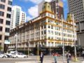 The Downing Centre, formerly Mark Foy's Piazza store
 -
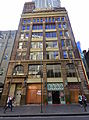
 Commercial building in Victorian style
 -
 Kent House


See also
 Australian Roads portal

References
- ^ "Pressed Metal, Wall Panels, Ceiling Panels and Splashbacks - Wunderlite Reproduction Panels".
External links
![]() Media related to Liverpool Street, Sydney at Wikimedia Commons
Media related to Liverpool Street, Sydney at Wikimedia Commons
33°52′35″S 151°12′22″E / 33.87639°S 151.20611°E / -33.87639; 151.20611
- v
- t
- e
Streets of Sydney, New South Wales, Australia
- Albion Street
- Alfred Street
- Bathurst Street
- Bridge Street
- Bayswater Road
- Broadway
- Castlereagh Street
- Chalmers Street
- City Road
- Clarence Street
- Cleveland Street
- College Street
- Crown Street
- Eddy Avenue
- Elizabeth Street
- George Street
- Glebe Point Road
- Goulburn Street
- Grosvenor Street
- Harris Street
- Hay Street
- Hunter Street
- Kent Street
- King Street
- Lime Street
- Liverpool Street
- Macquarie Street
- Market Street
- Martin Place
- Oxford Street
- Park Street
- Phillip Street
- Pitt Street
- Queen's Square
- Rowe Street
- Stanley Street
- Sussex Street
- Victoria Street
- Whitlam Square
- William Street
- York Street
- Anzac Parade
- Appian Way
- Bangor Bypass
- Barrenjoey Road
- Blacktown Road
- Bondi Road
- Burnt Bridge Creek Deviation
- City West Link
- Cumberland Highway
- Darling Street
- Epping Road
- General Holmes Drive
- Gore Hill Freeway
- Great North Road
- Great Western Highway
- Heathcote Road
- Henry Lawson Drive
- The Horsley Drive
- Hume Highway
- James Ruse Drive
- Jeffrey Street
- King Georges Road
- King Street
- Lane Cove Road
- New South Head Road
- Norton Street
- Old South Head Road
- Old Windsor Road
- Parramatta Road
- Pennant Hills Road
- Pittwater Road
- Princes Highway
- Prospect Highway
- Richmond Road
- Ryde Road
- Southern Cross Drive
- Syd Einfeld Drive
- Taren Point Road
- Victoria Road
- Windsor Road
- Wolseley Road


