Lygra
60°41′49″N 5°05′54″E / 60.6970°N 5.0984°E / 60.6970; 5.0984Area 2.5 km2 (0.97 sq mi) Length 4 km (2.5 mi) Width 680 m (2230 ft) Highest elevation 52 m (171 ft) Administration County Vestland Municipality Alver Municipality
Norway
Luro or Lygra is an island in Alver Municipality in Vestland county, Norway. The 2.5-square-kilometre (0.97 sq mi) island sits in the Lurefjorden which cuts into the Lindås peninsula. There is one road on the island that continues over a short bridge onto the mainland. The bridge was built in 1972. The island has been the site of Lygra Church since the Middle Ages. There are Viking Age tombstones that are still standing on the island. The Heathland Centre is located on Lygra. It is an information centre about the cultural landscape in this coastal area. There are nearly 200 hectares (490 acres) of heathland that are managed in traditional ways by local farmers.[1][2]
- Hike across the island of Lygra
-
 Typical landscape
 -
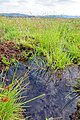 Moor pool
 -
 Heather covers large areas of the island
 -
 Heathland Center
 -
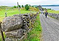 Natural stone walls on the way to the Heathland Center


See also
References
- v
- t
- e


