M G Road, Bangalore
Road in Bangalore, India
12°58′26″N 77°36′43″E / 12.973801°N 77.611885°E / 12.973801; 77.611885

Mahatma Gandhi Road also known as MG Road is a road in Bangalore, India. It runs east from Trinity Circle at one end to Anil Kumble Circle at the other. Known as South Parade in pre-independence era, it was renamed as Mahatma Gandhi Road on 26 February 1948.[1]
M. G. Road is also one of the busiest roads in the city and is lined on one side with retail stores, food outlets, restaurants and many more. It has many office buildings, shops and theatres. It is also a home to many buildings and banks. There are two Metro stations on M. G. Road, the eponymous station and Trinity.
Presently, the M.G Road Boulevard is being reconstructed after construction of the MG Road Metro station was completed and services launched on 20 October 2011.[2] The Bangalore Metro line that runs through MG Road, connects the eastern part of Bengaluru with the west.
-
 M.G. Road in 1950
 -
 M G Road in 2007 before construction of metro rail
 -
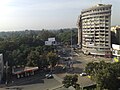 MG Road in 2007 as seen from Taj Residency Hotel
 -
 MG Road metro station in 2017


Location
Areas of Bengaluru | ||||||||||||||||
|---|---|---|---|---|---|---|---|---|---|---|---|---|---|---|---|---|
| ||||||||||||||||


See also
- Tourist attractions in Bangalore
- Mahatma Gandhi Road (Secunderabad)
- Brigade Road
References
External links
Wikimedia Commons has media related to MG Road, Bangalore.
- v
- t
- e
Bangalore
- Bangalore Cantonment
- Bangalore Fort
- Bengaluru Pete
- Chalukyas
- Hoysalas
- Kadambas
- Kempe Gowda
- Kingdom of Mysore
- Rashtrakutas
- Vijayanagara
- Western Gangas
- Tippu Sultan
| Lakes |
|
|---|
administration
| Municipal elections | |||||
|---|---|---|---|---|---|
| Municipal Corporation |
|
- 100 Feet Road
- Avenue Road
- Bannerghatta Road (SH 87)
- Brigade Road
- Church Street
- Cunningham Road
- Hosur Road (NH 7)
- Inner Ring Road
- J C Road
- Kasturba Road
- Lavelle Road
- M.G. Road
- Mysore Road (SH 17)
- NICE Road
- Old Airport Road
- Outer Ring Road
- Peripheral Ring Road
- Tannery Road
worship
| Periodic events |
|---|
| Cinemas |
|---|
| Sports |
|---|
| Others |
|---|

 | This Indian road or road transport-related article is a stub. You can help Wikipedia by expanding it. |
- v
- t
- e


