Maulden Heath
| Site of Special Scientific Interest | |
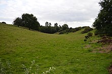 The western meadow | |
| Location | Bedfordshire |
|---|---|
| Grid reference | TL070386 TL 068384 |
| Interest | Biological |
| Area | 7.6 hectares |
| Notification | 1986 |
| Location map | Magic Map |
Maulden Heath is a 7.6-hectare (19-acre) Site of Special Scientific Interest in Maulden in Bedfordshire. It was notified in 1986 under Section 28 of the Wildlife and Countryside Act 1981, and the local planning authority is Central Bedfordshire Council.[1][2] The site is owned by the Forestry Commission and managed by The Greensand Trust.[3]
There are two separate meadows in the site. The eastern meadow has two ridges, which have short grass, a moss layer and many herbs. The western meadow is a steep-sided valley which has similar habitats.[1] There is access by a footpath from the Deadman's Hill car park.[2][3]
Wikimedia Commons has media related to Maulden Heath.
References
- ^ a b "Maulden Heath citation" (PDF). Sites of Special Scientific Interest. Natural England. Retrieved 28 August 2015.
- ^ a b "Map of Maulden Heath". Sites of Special Scientific Interest. Natural England. Retrieved 28 August 2015.
- ^ a b "Heath and Reach Sites". The Greensand Trust. Archived from the original on 10 August 2015. Retrieved 28 August 2015.
- v
- t
- e
Sites of Special Scientific Interest in Bedfordshire
- Barton Hills
- Blow's Down
- Cooper's Hill
- Deacon Hill
- Dropshort Marsh
- Dunstable and Whipsnade Downs
- Fancott Woods and Meadows
- Felmersham Gravel Pits
- Flitwick Moor
- Galley and Warden Hills
- Hanger Wood
- Houghton Regis Marl Lakes
- Kings and Bakers Woods and Heaths
- Kings Wood and Glebe Meadows, Houghton Conquest
- Knocking Hoe
- Marston Thrift
- Maulden Church Meadow
- Maulden Heath
- Maulden Wood and Pennyfather's Hill
- Nares Gladley Marsh
- Odell Great Wood
- Potton Wood
- Pulloxhill Marsh
- Sandy Warren
- Smithcombe, Sharpenhoe and Sundon Hills
- Southill Lake and Woods
- Stevington Marsh
- Sundon Chalk Quarry
- Swineshead Wood
- Tebworth Marsh
- Tilwick Meadow
- Totternhoe Chalk Quarry
- Totternhoe Knolls
- Wavendon Heath Ponds
- Yelden Meadows
52°02′06″N 0°26′31″W / 52.035°N 0.442°W / 52.035; -0.442


