Monte Cinto
Highest mountain on the island of Corsica


Monte Cinto
Corsica, France
Monte Cinto (Corsican: Monte Cintu) is the highest mountain on the island of Corsica, a region of France.
Geography
The elevation of the mountain is 2,706 metres (8,878 ft) and so is its prominence, making it one of the most prominent peaks in Europe. It is the highest peak of the Monte Cinto massif, one of the four main massifs in Corsica.
Its location gives it a theoretical panorama of mountains on mainland Europe stretching from near Marseille to Rome. The most distant mountain theoretically visible is Monte Rosa in Italy, just west of north, approximately 405 km (252 mi) away.[2]
History
The first known ascent of Monte Cinto was on 6 June 1882, by a party led by Édouard Rochat who reached the summit via the mountain's southern slopes. On 26 May 1883 a party led by the English mountaineer Francis Fox Tuckett, and including the French guide François Devouassoud and the landscape painter Edward Theodore Compton, also ascended the mountain by the pass that now bears Tuckett's name.
Today, the GR 20 hiking trail passes close to Monte Cinto, and walkers can make a short detour to the summit.
See also
References
- ^ a b "Europe Ultra-Prominences" Archived 2017-06-09 at the Wayback Machine Peaklist.org. Retrieved 2012-03-05.
- ^ http://www.viewfinderpanoramas.org/panoramas/EUR/CINTO-N.gif Archived 2017-03-12 at the Wayback Machine [bare URL image file]
External links
- Computer generated digital panoramas from Monte Cinto: North South
- More information and trip report
- "Monte Cinto, France" on Peakbagger
- v
- t
- e
- Spain: Mulhacén
- Aneto
- Torre de Cerredo
- Almanzor — Massif Central: Puy de Sancy
- Canaries: Teide
- Roque de los Muchachos
- Pico de las Nieves
- Malpaso — Azores: Pico
- Madeira: Ruivo
- Mont Blanc
- Grossglockner
- Finsteraarhorn
- Wildspitze
- Bernina
- Hochkönig
- Dufourspitze
- Hoher Dachstein
- Marmolada
- Viso
- Triglav
- Barre des Écrins
- Säntis
- Ortler
- Baldo
- Gran Paradiso
- Coca
- Cima Dodici
- Dents du Midi
- Chamechaude
- Zugspitze
- Antelao
- Arcalod
- Grintovec
- Großer Priel
- Grigna Settentrionale
- Bondone
- Presanella
- Birnhorn
- Col Nudo
- Pointe Percée
- Jôf di Montasio
- Polinik
- Tödi
- Birkkarspitze
- Ellmauer Halt
- Grande Tête de l'Obiou
- Hochtor
- Grimming
- Grand Combin
- Tournette
- Zirbitzkogel
- Kesch
- Cima Brenta
- Corno Grande
- Amaro
- Serra Dolcedorme
- Montalto
- Cimone
- Carpathians: Gerlachovský štít
- Parângu Mare
- Moldoveanu
- Peleaga
- Pietrosul Rodnei — Crimea: Roman-Kosh — Urals: Narodnaya
- Musala
- Olympus
- Vihren
- Taygetus
- Korab
- Jezercë
- Athos
- Kyllini
- Ossa
- Papingu
- Pangaion Hills
- Kajmakčalan
- Smolikas
- Giona
- Jakupica
- Këndrevica
- Radomir
- Parnassus
- Botev
- Çika
- Valamara
- Baba
- Psili Koryfi
Landforms of the Haute-Corse department  | ||
|---|---|---|
| Massifs | 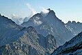 | |
| Peaks | ||
| Passes |
| |
| ||
 | This Haute-Corse geographical article is a stub. You can help Wikipedia by expanding it. |
- v
- t
- e


