National Register of Historic Places listings in Big Cypress National Preserve
This is a list of the National Register of Historic Places listings in Big Cypress National Preserve.
This is intended to be a complete list of the properties and districts on the National Register of Historic Places in Big Cypress National Preserve, Florida, United States. The locations of National Register properties and districts for which the latitude and longitude coordinates are included below, may be seen in a Google map.[1]
There are nine properties and districts listed on the National Register in the park.
This National Park Service list is complete through NPS recent listings posted June 21, 2024.[2]
Map all coordinates using OpenStreetMap
Download coordinates as:
- KML
- GPX (all coordinates)
- GPX (primary coordinates)
- GPX (secondary coordinates)
Current listings
| [3] | Name on the Register | Image | Date listed[4] | Location | City or town | Description |
|---|---|---|---|---|---|---|
| 1 | Burns Lake Site (8CR259) | Upload image | May 27, 1986 (#86001192) | Address Restricted | Ochopee | |
| 2 | Halfway Creek Site | Upload image | August 15, 1980 (#80000365) | Address Restricted | Carnestown | |
| 3 | Hinson Mounds | Upload image | December 29, 1978 (#78000345) | Address Restricted | Miles City | |
| 4 | C. J. Ostl Site | Upload image | December 15, 1978 (#78003380) | Address Restricted | Ochopee | |
| 5 | Platt Island | Upload image | December 14, 1978 (#78000934) | Northeast of Miles City off State Road 29[5] 26°12′46″N 81°18′15″W / 26.212778°N 81.304167°W / 26.212778; -81.304167 (Platt Island) | Miles City | |
| 6 | Plaza Site (8CR303) | Upload image | May 28, 1986 (#86001196) | Address Restricted | Ochopee | |
| 7 | Sugar Pot Site | Upload image | December 15, 1978 (#78000264) | Address Restricted | Ochopee | |
| 8 | Turner River Site | Upload image | December 14, 1978 (#78000263) | Address Restricted | Ochopee |
Former listings
| [3] | Name on the Register | Image | Date listed | Date removed | Location | City or town | Description |
|---|---|---|---|---|---|---|---|
| 1 | Monroe Station (Ochopee, Florida) | 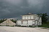 | May 11, 2000 (#00000427) | May 15, 2019 | Junction of the Tamiami Trail and Loop Road 25°51′46″N 81°06′01″W / 25.862778°N 81.100278°W / 25.862778; -81.100278 (Monroe Station (Ochopee, Florida)) | Ochopee | Destroyed by fire[6] |
See also
- National Register of Historic Places listings in Collier County, Florida
- National Register of Historic Places listings in Florida
References
Wikimedia Commons has media related to National Register of Historic Places in Big Cypress National Preserve.
- ^ The latitude and longitude information provided in this table was derived originally from the National Register Information System, which has been found to be fairly accurate for about 99% of listings. Some locations in this table may have been corrected to current GPS standards.
- ^ National Park Service, United States Department of the Interior, "National Register of Historic Places: Weekly List Actions", retrieved June 21, 2024.
- ^ a b Numbers represent an alphabetical ordering by significant words. Various colorings, defined here, differentiate National Historic Landmarks and historic districts from other NRHP buildings, structures, sites or objects.
- ^ The eight-digit number below each date is the number assigned to each location in the National Register Information System database, which can be viewed by clicking the number.
- ^ Location derived from its GNIS feature record; the NRIS lists the site as "Address Restricted"
- ^ "Photographer Accidentally Burns Down Historic Landmark". May 9, 2016.
- v
- t
- e
See also: National Register of Historic Places listings in Big Cypress National Preserve
| |
|---|---|
| Topics | |
| Lists by state |
|
| Lists by insular areas | |
| Lists by associated state | |
| Other areas | |
| Related | |
| |


