National Register of Historic Places listings in Deer Lodge County, Montana
This is a list of the National Register of Historic Places listings in Deer Lodge County, Montana. It is intended to be a complete list of the properties and districts on the National Register of Historic Places in Deer Lodge County, Montana, United States. All sites are located in the city of Anaconda, which is consolidated with Deer Lodge County. The locations of National Register properties and districts for which the latitude and longitude coordinates are included below, may be seen in a map.[1]
There are 35 properties and districts listed on the National Register in the county, including 1 National Historic Landmark.
This National Park Service list is complete through NPS recent listings posted September 13, 2024.[2]
Map all coordinates using OpenStreetMap
Download coordinates as:
- KML
- GPX (all coordinates)
- GPX (primary coordinates)
- GPX (secondary coordinates)
Listings county-wide
| [3] | Name on the Register[4] | Image | Date listed[5] | Location | City or town | Description |
|---|---|---|---|---|---|---|
| 1 | Alpine Apartments | 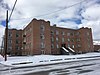 | October 30, 1998 (#98001299) | 200 Hickory 46°07′46″N 112°57′13″W / 46.129444°N 112.953611°W / 46.129444; -112.953611 (Alpine Apartments) | Anaconda | |
| 2 | Anaconda Commercial Historic District |  | February 25, 1998 (#98000155) | Roughly bounded by Commercial Ave., Main St., Chestnut St., and E. Park Ave. 46°07′46″N 112°56′57″W / 46.129444°N 112.949167°W / 46.129444; -112.949167 (Anaconda Commercial Historic District) | Anaconda | |
| 3 | Anaconda Copper Mining Company Smoke Stack |  | April 9, 1987 (#87000607) | Anaconda Copper Smelter 46°06′37″N 112°54′47″W / 46.110278°N 112.913056°W / 46.110278; -112.913056 (Anaconda Copper Mining Company Smoke Stack) | Anaconda | |
| 4 | Anaconda Saddle Club |  | January 24, 2007 (#06001296) | 2704 Montana Highway 1, W. 46°09′22″N 113°02′07″W / 46.1562°N 113.0353°W / 46.1562; -113.0353 (Anaconda Saddle Club) | Anaconda | |
| 5 | Ancient Order of Hibernians Hall |  | August 10, 1979 (#79003721) | 321-323 E. Commercial 46°07′46″N 112°56′54″W / 46.129444°N 112.948333°W / 46.129444; -112.948333 (Ancient Order of Hibernians Hall) | Anaconda | |
| 6 | Barich Block |  | January 19, 1983 (#83001058) | 416-420 E. Park Ave. 46°07′47″N 112°57′05″W / 46.129722°N 112.951389°W / 46.129722; -112.951389 (Barich Block) | Anaconda | |
| 7 | Branscombe Automobile Machine Shop | 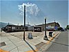 | December 18, 2000 (#00001522) | 125 W. Commercial 46°07′56″N 112°57′14″W / 46.132222°N 112.953889°W / 46.132222; -112.953889 (Branscombe Automobile Machine Shop) | Anaconda | |
| 8 | Butte, Anaconda and Pacific Railway Historic District |  | October 13, 1988 (#88001111) | Right-of-way begins in Butte and travels to Anaconda, generally along the course of Silver Bow Creek 46°02′37″N 112°44′25″W / 46.043611°N 112.740278°W / 46.043611; -112.740278 (Butte, Anaconda and Pacific Railway Historic District) | Anaconda | Extends into Silver Bow County |
| 9 | Butte-Anaconda Historic District |  | October 15, 1966 (#66000438) | Most of the developed areas of Anaconda, Butte, and Walkerville 46°07′45″N 112°57′10″W / 46.129167°N 112.952778°W / 46.129167; -112.952778 (Butte-Anaconda Historic District) | Anaconda | Extends into Silver Bow County |
| 10 | California Creek Quarry | Upload image | January 20, 1989 (#88003140) | Address restricted[6] | Anaconda | |
| 11 | City Hall |  | August 10, 1979 (#79003722) | 401 E. Commercial 46°07′46″N 112°56′51″W / 46.129444°N 112.9475°W / 46.129444; -112.9475 (City Hall) | Anaconda | |
| 12 | Club Moderne |  | August 14, 1986 (#86001498) | 811 E. Park 46°07′40″N 112°56′38″W / 46.127778°N 112.943889°W / 46.127778; -112.943889 (Club Moderne) | Anaconda | Heavily damaged by fire October 3, 2016[7] |
| 13 | James V. Collins House |  | December 18, 2000 (#00001521) | 422 W. 3rd St. 46°07′52″N 112°57′31″W / 46.131111°N 112.958611°W / 46.131111; -112.958611 (James V. Collins House) | Anaconda | |
| 14 | Davidson Building |  | January 19, 1983 (#83001059) | 301-303 E. Park St. 46°07′47″N 112°57′14″W / 46.129722°N 112.953889°W / 46.129722; -112.953889 (Davidson Building) | Anaconda | |
| 15 | Deer Lodge County Courthouse |  | December 29, 1978 (#78001681) | U.S. Route 10 46°07′21″N 112°57′18″W / 46.1225°N 112.955°W / 46.1225; -112.955 (Deer Lodge County Courthouse) | Anaconda | |
| 16 | Driver's Saloon and Café | Upload image | February 7, 2023 (#100008428) | 104-106 East Commercial Ave. 46°07′49″N 112°57′09″W / 46.1303°N 112.9524°W / 46.1303; -112.9524 (Driver's Saloon and Café) | Anaconda | |
| 17 | Theodore Eck House | 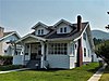 | October 30, 1998 (#98001298) | 1217 W. 4th St. 46°07′48″N 112°58′10″W / 46.13°N 112.969444°W / 46.13; -112.969444 (Theodore Eck House) | Anaconda | |
| 18 | John Furst House | 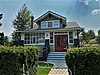 | October 30, 1998 (#98001296) | 1403 W. 3rd St. 46°07′53″N 112°58′16″W / 46.131389°N 112.971111°W / 46.131389; -112.971111 (John Furst House) | Anaconda | |
| 19 | Glenn's Dam Historic District | Upload image | March 16, 2020 (#100005107) | North Cable Rd., less than 1/4 mi. north of northwest end of town 46°08′32″N 112°58′59″W / 46.1421°N 112.9831°W / 46.1421; -112.9831 (Glenn's Dam Historic District) | Anaconda vicinity | |
| 20 | Glover Cabin |  | December 18, 2000 (#00001524) | Washoe Park 46°08′10″N 112°57′56″W / 46.136111°N 112.965556°W / 46.136111; -112.965556 (Glover Cabin) | Anaconda | |
| 21 | Goosetown Historic District | 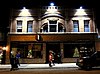 | February 25, 1998 (#98000156) | Roughly bounded by Cedar St., Monroe St., the Birch Hill Allotment, and E. Commercial Ave. 46°07′28″N 112°56′35″W / 46.124444°N 112.943056°W / 46.124444; -112.943056 (Goosetown Historic District) | Anaconda | |
| 22 | Granite Apartments |  | December 18, 2000 (#00001517) | 214 E. 3rd St. 46°07′48″N 112°57′04″W / 46.13°N 112.951111°W / 46.13; -112.951111 (Granite Apartments) | Anaconda | |
| 23 | Hearst Free Library |  | June 4, 1973 (#73001051) | Main and 4th Sts. 46°07′37″N 112°57′09″W / 46.126944°N 112.9525°W / 46.126944; -112.9525 (Hearst Free Library) | Anaconda | |
| 24 | Lorraine Apartments |  | December 18, 2000 (#00001520) | 218 E. 3rd 46°07′47″N 112°57′02″W / 46.129722°N 112.950556°W / 46.129722; -112.950556 (Lorraine Apartments) | Anaconda | |
| 25 | Duncan Matheson House |  | October 30, 1998 (#98001295) | 1300 W. 3rd St. 46°07′53″N 112°58′10″W / 46.131389°N 112.969444°W / 46.131389; -112.969444 (Duncan Matheson House) | Anaconda | |
| 26 | Methodist Episcopal Church of Anaconda |  | July 29, 1994 (#94000783) | Junction of Oak and E. 3rd Sts. 46°07′42″N 112°57′02″W / 46.128333°N 112.950556°W / 46.128333; -112.950556 (Methodist Episcopal Church of Anaconda) | Anaconda | |
| 27 | Morel Bridge | Upload image | December 12, 2000 (#00001491) | 25200 East Side Rd. 46°09′28″N 112°46′16″W / 46.157778°N 112.771111°W / 46.157778; -112.771111 (Morel Bridge) | Anaconda | |
| 28 | The New Brunswick House |  | December 18, 2000 (#00001514) | 325 E. Front 46°07′56″N 112°56′54″W / 46.132222°N 112.948333°W / 46.132222; -112.948333 (The New Brunswick House) | Anaconda | |
| 29 | Sheehan Boardinghouse |  | December 18, 2000 (#00001519) | 412 E. 3rd St. 46°07′42″N 112°56′54″W / 46.128333°N 112.948333°W / 46.128333; -112.948333 (Sheehan Boardinghouse) | Anaconda | |
| 30 | St. Mark's Episcopal Church |  | December 29, 1978 (#78001682) | 601 Main St. 46°07′29″N 112°57′14″W / 46.124722°N 112.953889°W / 46.124722; -112.953889 (St. Mark's Episcopal Church) | Anaconda | |
| 31 | US Post Office-Anaconda Main |  | March 14, 1986 (#86000677) | 218 Main St. 46°07′44″N 112°57′09″W / 46.128889°N 112.9525°W / 46.128889; -112.9525 (US Post Office-Anaconda Main) | Anaconda | |
| 32 | George Waddell House |  | October 30, 1998 (#98001300) | 506 W. 3rd St. 46°07′46″N 112°57′30″W / 46.129444°N 112.958333°W / 46.129444; -112.958333 (George Waddell House) | Anaconda | |
| 33 | Washoe Theater |  | April 30, 1982 (#82003162) | 305 Main St. 46°07′39″N 112°57′08″W / 46.1275°N 112.952222°W / 46.1275; -112.952222 (Washoe Theater) | Anaconda | |
| 34 | West Side Historic District |  | April 28, 1998 (#98000396) | Roughly bounded by Main St., W. 8th St., W. Park Ave., and Maple St. 46°07′33″N 112°57′17″W / 46.125833°N 112.954722°W / 46.125833; -112.954722 (West Side Historic District) | Anaconda | |
| 35 | Zion Swedish Evangelical Lutheran Church |  | October 30, 1998 (#98001297) | 524 Cedar St. 46°07′29″N 112°56′57″W / 46.124722°N 112.949167°W / 46.124722; -112.949167 (Zion Swedish Evangelical Lutheran Church) | Anaconda |
Former listings
| [3] | Name on the Register | Image | Date listed | Date removed | Location | City or town | Description |
|---|---|---|---|---|---|---|---|
| 1 | Montana Hotel, briefly Marcus Daly Hotel |  | April 26, 1973 (#73001052) | June 18, 1979 | Park Ave. and S. Main St. | Anaconda | Briefly known as the Marcus Daly Hotel in the 1970s, the structure lost a significant amount of its original character when the upper two floors were removed[8] |
| 2 | Durston Block and Annex |  | January 18, 1984 (#84002461) | June 3, 1986 | 201-205 1/2 Main St. | Anaconda | Destroyed by fire on February 9, 1985.[9] |
See also
Wikimedia Commons has media related to National Register of Historic Places in Deer Lodge County, Montana.
- List of National Historic Landmarks in Montana
- National Register of Historic Places listings in Montana
References
- ^ The latitude and longitude information provided in this table was derived originally from the National Register Information System, which has been found to be fairly accurate for about 99% of listings. Some locations in this table may have been corrected to current GPS standards.
- ^ National Park Service, United States Department of the Interior, "National Register of Historic Places: Weekly List Actions", retrieved September 13, 2024.
- ^ a b Numbers represent an alphabetical ordering by significant words. Various colorings, defined here, differentiate National Historic Landmarks and historic districts from other NRHP buildings, structures, sites or objects.
- ^ "National Register Information System". National Register of Historic Places. National Park Service. April 24, 2008.
- ^ The eight-digit number below each date is the number assigned to each location in the National Register Information System database, which can be viewed by clicking the number.
- ^ Federal and state laws and practices restrict general public access to information regarding the specific location of this resource. In some cases, this is to protect archeological sites from vandalism, while in other cases it is restricted at the request of the owner. See: Knoerl, John; Miller, Diane; Shrimpton, Rebecca H. (1990), Guidelines for Restricting Information about Historic and Prehistoric Resources, National Register Bulletin, National Park Service, U.S. Department of the Interior, OCLC 20706997.
- ^ "Life after death: Historic Anaconda bar reborn after devastation by fire".
- ^ Hawley, Monica (1984). "Anaconda Historic District - Marcus Daly Hotel" (PDF). Historic American Buildings Survey. Retrieved January 26, 2016.
- ^ "Fire claims historic building in Anaconda". The Montana Standard. February 10, 1985. p. 1. Retrieved August 4, 2022 – via Newspapers.com.
- v
- t
- e
- Beaverhead
- Big Horn
- Blaine
- Broadwater
- Carbon
- Carter
- Cascade
- Chouteau
- Custer
- Daniels
- Dawson
- Deer Lodge
- Fallon
- Fergus
- Flathead
- Gallatin
- Garfield
- Glacier
- Golden Valley
- Granite
- Hill
- Jefferson
- Judith Basin
- Lake
- Lewis and Clark
- Liberty
- Lincoln
- Madison
- McCone
- Meagher
- Mineral
- Missoula
- Musselshell
- Park
- Petroleum
- Phillips
- Pondera
- Powder River
- Powell
- Prairie
- Ravalli
- Richland
- Roosevelt
- Rosebud
- Sanders
- Sheridan
- Silver Bow
- Stillwater
- Sweet Grass
- Teton
- Toole
- Treasure
- Valley
- Wheatland
- Wibaux
- Yellowstone

- Bridges
- Historic districts
- Houses
- National Historic Landmarks
- Properties of religious function
- Railway stations


