National Register of Historic Places listings in Payette County, Idaho

This is a list of the National Register of Historic Places listings in Payette County, Idaho.
This is intended to be a complete list of the properties on the National Register of Historic Places in Payette County, Idaho, United States. Latitude and longitude coordinates are provided for many National Register properties and districts; these locations may be seen together in a map.[1]
There are 15 properties listed on the National Register in the county. More may be added; properties and districts nationwide are added to the Register weekly.[2]
This National Park Service list is complete through NPS recent listings posted September 5, 2024.[3]
Map all coordinates using OpenStreetMap
Download coordinates as:
- KML
- GPX (all coordinates)
- GPX (primary coordinates)
- GPX (secondary coordinates)
Current listings
| [4] | Name on the Register[5] | Image | Date listed[6] | Location | City or town | Description |
|---|---|---|---|---|---|---|
| 1 | David C. Chase House |  | February 7, 1978 (#78001091) | 307 N. 9th St. 44°04′43″N 116°56′02″W / 44.078473°N 116.933980°W / 44.078473; -116.933980 (David C. Chase House) | Payette | |
| 2 | Coughanour Apartment Block |  | May 23, 1978 (#78001092) | 700–718 1st Ave., N. 44°04′33″N 116°56′10″W / 44.075752°N 116.936122°W / 44.075752; -116.936122 (Coughanour Apartment Block) | Payette | Building no longer exists. |
| 3 | N. A. Jacobsen Building |  | November 17, 1982 (#82000358) | N. 8th St. and 1st Ave. 44°04′33″N 116°56′05″W / 44.075754°N 116.934696°W / 44.075754; -116.934696 (N. A. Jacobsen Building) | Payette | |
| 4 | N. A. Jacobsen House |  | January 7, 1998 (#97001610) | 1115 1st Ave., N. 44°04′35″N 116°55′48″W / 44.076323°N 116.929937°W / 44.076323; -116.929937 (N. A. Jacobsen House) | Payette | |
| 5 | Methodist Episcopal Church of Payette | 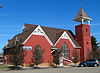 | October 5, 1977 (#77000469) | 90 S. 9th St. 44°04′26″N 116°56′02″W / 44.073949°N 116.933878°W / 44.073949; -116.933878 (Methodist Episcopal Church of Payette) | Payette | |
| 6 | A. B. Moss Building |  | February 8, 1978 (#78001093) | 137 N. 8th St. 44°04′37″N 116°56′07″W / 44.076813°N 116.935361°W / 44.076813; -116.935361 (A. B. Moss Building) | Payette | |
| 7 | New Plymouth Congregational Church |  | November 17, 1982 (#82000359) | 207 Southwest Ave. 43°58′08″N 116°49′17″W / 43.969010°N 116.821415°W / 43.969010; -116.821415 (New Plymouth Congregational Church) | New Plymouth | |
| 8 | J. C. Palumbo Fruit Company Packing and Warehouse Building | 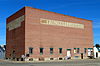 | November 17, 1982 (#82000360) | 2nd Ave., S., and 6th St. 44°04′22″N 116°56′15″W / 44.072844°N 116.937608°W / 44.072844; -116.937608 (J. C. Palumbo Fruit Company Packing and Warehouse Building) | Payette | |
| 9 | Payette City Hall and Courthouse |  | May 14, 1979 (#79000808) | 3rd Ave., N., and 8th St. 44°04′41″N 116°56′05″W / 44.077944°N 116.934628°W / 44.077944; -116.934628 (Payette City Hall and Courthouse) | Payette | |
| 10 | Portia Club | 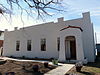 | April 7, 2010 (#10000159) | 225 N. 9th St. 44°04′40″N 116°56′02″W / 44.077669°N 116.933864°W / 44.077669; -116.933864 (Portia Club) | Payette | |
| 11 | St. James Episcopal Church |  | April 20, 1978 (#78001094) | 1st Ave., N. and 10th St. 44°04′34″N 116°55′54″W / 44.076158°N 116.931686°W / 44.076158; -116.931686 (St. James Episcopal Church) | Payette | |
| 12 | St. John's Church |  | June 5, 2013 (#13000353) | 350 N. 4th St. 44°04′46″N 116°56′27″W / 44.079354°N 116.940867°W / 44.079354; -116.940867 (St. John's Church) | Payette | |
| 13 | U.S. Post Office – Payette Main | 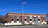 | March 16, 1989 (#89000134) | 915 Center Ave. 44°04′31″N 116°55′59″W / 44.075144°N 116.933164°W / 44.075144; -116.933164 (U.S. Post Office – Payette Main) | Payette | |
| 14 | Grant Whitney House |  | February 23, 1978 (#78001095) | 1015 7th Ave., N. 44°04′56″N 116°55′54″W / 44.082231°N 116.931659°W / 44.082231; -116.931659 (Grant Whitney House) | Payette | Building no longer exists. |
| 15 | Woodward Building |  | April 26, 1978 (#78001096) | 23 8th St. 44°04′27″N 116°56′05″W / 44.074256°N 116.934703°W / 44.074256; -116.934703 (Woodward Building) | Payette |
See also
Wikimedia Commons has media related to National Register of Historic Places in Payette County, Idaho.
References
- ^ The latitude and longitude information provided in this table was derived originally from the National Register Information System, which has been found to be fairly accurate for about 99% of listings. Some locations in this table may have been corrected to current GPS standards.
- ^ "National Register of Historic Places: Weekly List Actions". National Park Service. Retrieved March 29, 2009.
- ^ National Park Service, United States Department of the Interior, "National Register of Historic Places: Weekly List Actions", retrieved September 5, 2024.
- ^ Numbers represent an alphabetical ordering by significant words. Various colorings, defined here, differentiate National Historic Landmarks and historic districts from other NRHP buildings, structures, sites or objects.
- ^ "National Register Information System". National Register of Historic Places. National Park Service. April 24, 2008.
- ^ The eight-digit number below each date is the number assigned to each location in the National Register Information System database, which can be viewed by clicking the number.
- v
- t
- e
- Ada
- Adams
- Bannock
- Bear Lake
- Benewah
- Bingham
- Blaine
- Boise
- Bonner
- Bonneville
- Boundary
- Butte
- Camas
- Canyon
- Caribou
- Cassia
- Clark
- Clearwater
- Custer
- Elmore
- Franklin
- Fremont
- Gem
- Gooding
- Idaho
- Jefferson
- Jerome
- Kootenai
- Latah
- Lemhi
- Lewis
- Lincoln
- Madison
- Minidoka
- Nez Perce
- Oneida
- Owyhee
- Payette
- Power
- Shoshone
- Teton
- Twin Falls
- Valley
- Washington

| |
|---|---|
| Topics | |
| Lists by state |
|
| Lists by insular areas | |
| Lists by associated state | |
| Other areas | |
| Related | |
| |


Municipalities and communities of Payette County, Idaho, United States | ||
|---|---|---|
County seat: Payette | ||
| Cities |  | |
| Unincorporated communities | ||
| Footnotes | ‡This populated place also has portions in an adjacent county or counties | |
| ||


