National Register of Historic Places listings in Providence County, Rhode Island

This is a list of the National Register of Historic Places listings in Providence County, Rhode Island.
This is intended to be a complete list of the properties and districts on the National Register of Historic Places in Providence County, Rhode Island, United States. Latitude and longitude coordinates are provided for many National Register properties and districts; these locations may be seen together in a map.[1]
There are 434 properties and districts listed on the National Register in the county, including 15 National Historic Landmarks. The cities of Pawtucket, Woonsocket, and Providence include 57, 43, and 169 of these properties and districts — including 1 and 12 National Historic Landmarks — respectively; they are listed separately. Properties and districts located in the county's other municipalities, including 2 National Historic Landmarks, are listed here. The Blackstone Canal, which extends through Providence, Pawtucket, Woonsocket, and other communities appears here and on the Providence and Pawtucket lists; the Conant Thread-Coats & Clark Mill Complex District is in both Central Falls and Pawtucket, and is thus listed below and on the Pawtucket list. The Norwood Avenue Historic District is located in both Providence and Cranston.
- v
- t
- e
- Bristol
- Kent
- Newport
- Providence (Providence (city), Pawtucket, Woonsocket)
- Washington (New Shoreham)
This National Park Service list is complete through NPS recent listings posted August 30, 2024.[2]
Map all coordinates using OpenStreetMap
Download coordinates as:
- KML
- GPX (all coordinates)
- GPX (primary coordinates)
- GPX (secondary coordinates)
Current listings
Pawtucket
Providence
Woonsocket
Other communities
| [3] | Name on the Register[4] | Image | Date listed[5] | Location | City or town | Description |
|---|---|---|---|---|---|---|
| 1 | Albion Historic District |  | July 19, 1984 (#84001899) | Roughly bounded by Berkshire Dr., Willow Lane, Ledge Way, Kennedy Boulevard, and School and Main Sts. 41°57′06″N 71°27′26″W / 41.951667°N 71.457222°W / 41.951667; -71.457222 (Albion Historic District) | Lincoln | |
| 2 | Allendale Mill |  | May 7, 1973 (#73000063) | 494 Woonasquatucket Ave. 41°51′00″N 71°28′51″W / 41.85°N 71.480833°W / 41.85; -71.480833 (Allendale Mill) | North Providence | |
| 3 | Allenville Mill Storehouse |  | January 20, 1972 (#72000033) | 5 Esmond St. 41°52′41″N 71°30′09″W / 41.878056°N 71.5025°W / 41.878056; -71.5025 (Allenville Mill Storehouse) | Smithfield | |
| 4 | American Supply Company Building |  | May 8, 2017 (#100000978) | 1420 Broad St. 41°53′56″N 71°23′24″W / 41.898913°N 71.390062°W / 41.898913; -71.390062 (American Supply Company Building) | Central Falls | |
| 5 | Andrews Mill Company Plant | Upload image | September 13, 2018 (#100002937) | 761 Great Rd. 42°00′00″N 71°33′13″W / 42.0000°N 71.5536°W / 42.0000; -71.5536 (Andrews Mill Company Plant) | North Smithfield | |
| 6 | Andrews–Luther Farm |  | June 19, 1985 (#85001352) | Elmdale Rd. 41°51′08″N 71°36′04″W / 41.852222°N 71.601111°W / 41.852222; -71.601111 (Andrews–Luther Farm) | Scituate | |
| 7 | Daniel Angell House |  | April 21, 1975 (#75000056) | 15 Dean Ave. 41°52′46″N 71°30′01″W / 41.879444°N 71.500278°W / 41.879444; -71.500278 (Daniel Angell House) | Johnston | |
| 8 | Otis Angell Gristmill |  | November 3, 2017 (#100001779) | 1 Governor Notte Pkwy. 41°52′13″N 71°27′39″W / 41.870408°N 71.460828°W / 41.870408; -71.460828 (Otis Angell Gristmill) | North Providence | |
| 9 | Angell–Ballou House |  | March 18, 2004 (#04000196) | 49 Ridge Rd. 41°53′42″N 71°30′05″W / 41.895°N 71.501389°W / 41.895; -71.501389 (Angell–Ballou House) | Smithfield | |
| 10 | Arkwright Bridge |  | December 12, 1978 (#78000061) | Crosses the Pawtuxet River at Hill St. 41°43′49″N 71°32′49″W / 41.730278°N 71.546944°W / 41.730278; -71.546944 (Arkwright Bridge) | Cranston | Extends into Kent County |
| 11 | Arnold Mills Historic District |  | December 28, 1978 (#78000070) | East of Cumberland Hill at Sneech Pond, Attleboro, and Abbott Run Valley Rds. 41°58′46″N 71°23′30″W / 41.979444°N 71.391667°W / 41.979444; -71.391667 (Arnold Mills Historic District) | Cumberland | |
| 12 | Dexter Arnold Farmstead |  | November 25, 1977 (#77001586) | Chopmist Hill Rd. 41°48′59″N 71°39′54″W / 41.816389°N 71.665°W / 41.816389; -71.665 (Dexter Arnold Farmstead) | Scituate | |
| 13 | Eleazer Arnold House |  | November 24, 1968 (#68000006) | Great Rd. (RI 123) near its junction with RI 126 41°54′10″N 71°25′14″W / 41.902778°N 71.420556°W / 41.902778; -71.420556 (Eleazer Arnold House) | Lincoln | |
| 14 | Israel Arnold House |  | December 18, 1970 (#70000017) | Great Rd. 41°54′17″N 71°25′35″W / 41.904722°N 71.426389°W / 41.904722; -71.426389 (Israel Arnold House) | Lincoln | |
| 15 | Peleg Arnold Tavern |  | July 30, 1974 (#74000046) | Woonsocket Hill Rd. 41°59′21″N 71°32′02″W / 41.989167°N 71.533889°W / 41.989167; -71.533889 (Peleg Arnold Tavern) | North Smithfield | |
| 16 | Ashton Historic District |  | November 1, 1984 (#84000367) | Roughly Mendon, Scott, and Old Angell Rds., Store Hill Rd., Front and Middle Sts. 41°56′20″N 71°25′54″W / 41.938889°N 71.431667°W / 41.938889; -71.431667 (Ashton Historic District) | Cumberland | |
| 17 | Ballou House |  | August 30, 1984 (#84001908) | Albion Rd. 41°56′48″N 71°28′21″W / 41.946667°N 71.4725°W / 41.946667; -71.4725 (Ballou House) | Lincoln | |
| 18 | Ballou–Weatherhead House |  | June 25, 1993 (#93000503) | Tower Hill Rd. (Pole 68) 41°59′47″N 71°26′38″W / 41.996389°N 71.443889°W / 41.996389; -71.443889 (Ballou–Weatherhead House) | Cumberland | |
| 19 | Battey–Barden House |  | August 29, 1980 (#80000084) | Plainfield Pike 41°47′30″N 71°37′08″W / 41.791667°N 71.618889°W / 41.791667; -71.618889 (Battey–Barden House) | Scituate | |
| 20 | Belknap School |  | December 7, 2010 (#10000978) | 509 Greenville Ave. 41°50′48″N 71°30′05″W / 41.846667°N 71.501389°W / 41.846667; -71.501389 (Belknap School) | Johnston | |
| 21 | Berkeley Mill Village |  | February 23, 1972 (#72000036) | Bounded roughly by Martin St., Mendon Rd., railroad, and cemetery 41°55′39″N 71°25′25″W / 41.9275°N 71.423611°W / 41.9275; -71.423611 (Berkeley Mill Village) | Cumberland | |
| 22 | Bicknell–Armington Lightning Splitter House |  | November 28, 1980 (#80000085) | 3591 Pawtucket Ave. 41°46′36″N 71°21′47″W / 41.776667°N 71.363056°W / 41.776667; -71.363056 (Bicknell–Armington Lightning Splitter House) | East Providence | |
| 23 | Blackstone Canal |  | May 6, 1971 (#71000030) | From Steeple and Promenade Sts. in Providence to the Massachusetts border in North Smithfield 41°55′16″N 71°25′21″W / 41.921111°N 71.4225°W / 41.921111; -71.4225 (Blackstone Canal) | Lincoln, Cumberland, and North Smithfield | Initial listing extended from Providence, through Pawtucket, and as far north as Lincoln; a 1991 expansion (#91001536) extended it to the state line; the canal itself extended into Worcester County, Massachusetts, where it is the subject of separate listings. |
| 24 | Borders Farm | 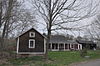 | July 29, 2009 (#09000576) | 31-38 N. Rd. 41°47′17″N 71°44′38″W / 41.787989°N 71.743828°W / 41.787989; -71.743828 (Borders Farm) | Foster | |
| 25 | Boston and Providence Railroad Bridge | 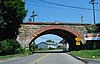 | November 28, 1980 (#80000086) | Spans the Ten Mile River 41°50′05″N 71°21′45″W / 41.834722°N 71.3625°W / 41.834722; -71.3625 (Boston and Providence Railroad Bridge) | East Providence | |
| 26 | Breezy Hill Site (RI-957) | Upload image | September 28, 1985 (#85002700) | Address Restricted | Foster | |
| 27 | Bridgeton School | 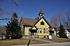 | December 27, 2006 (#06001191) | 16 Laurel Hill Ave. 41°57′52″N 71°42′47″W / 41.964444°N 71.713056°W / 41.964444; -71.713056 (Bridgeton School) | Burrillville | |
| 28 | Bridgham Farm |  | November 28, 1980 (#80000087) | 120, 148, 150, and 160 Pleasant St. 41°50′13″N 71°20′38″W / 41.836944°N 71.343889°W / 41.836944; -71.343889 (Bridgham Farm) | East Providence | |
| 29 | Brown Avenue Historic District |  | April 24, 1973 (#73000066) | Brown Ave. 41°50′44″N 71°32′37″W / 41.845556°N 71.543611°W / 41.845556; -71.543611 (Brown Avenue Historic District) | Johnston | |
| 30 | Burlingame–Noon House | 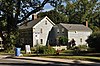 | February 15, 1974 (#74000048) | 3261 Mendon Rd. 41°58′32″N 71°27′25″W / 41.975556°N 71.456944°W / 41.975556; -71.456944 (Burlingame–Noon House) | Cumberland | |
| 31 | Carpenter, Lakeside, and Springvale Cemeteries |  | November 28, 1980 (#80000091) | Newman and Pawtucket Aves. 41°50′33″N 71°21′09″W / 41.8425°N 71.3525°W / 41.8425; -71.3525 (Carpenter, Lakeside, and Springvale Cemeteries) | East Providence | |
| 32 | Central Falls Congregational Church |  | July 12, 1976 (#76000042) | 376 High St. 41°53′05″N 71°23′04″W / 41.884722°N 71.384444°W / 41.884722; -71.384444 (Central Falls Congregational Church) | Central Falls | |
| 33 | Central Falls Mill Historic District | 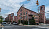 | July 2, 1976 (#76000007) | Between Roosevelt Avenue and the Blackstone River; also 381, 396, 403, 404, 413, 548, 558 Roosevelt Ave. 41°53′11″N 71°22′55″W / 41.886389°N 71.381944°W / 41.886389; -71.381944 (Central Falls Mill Historic District) | Central Falls | Second set of addresses represents a boundary increase approved January 29, 2018 |
| 34 | Central Street School |  | April 6, 1979 (#79000004) | 379 Central St. 41°53′04″N 71°23′38″W / 41.884444°N 71.393889°W / 41.884444; -71.393889 (Central Street School) | Central Falls | |
| 35 | Chepachet Village Historic District |  | March 31, 1971 (#71000031) | Both sides of U.S. Route 44 (roughly from the intersection of U.S. Route 44 and RI 102 north to the intersection of RI 100 and RI 102) and radiating 41°54′46″N 71°40′00″W / 41.912778°N 71.666667°W / 41.912778; -71.666667 (Chepachet Village Historic District) | Glocester | |
| 36 | Cherry Valley Archeological Site, RI-279 | Upload image | November 1, 1984 (#84000358) | Address Restricted | Glocester | |
| 37 | Clayville Historic District |  | December 29, 1988 (#88003079) | Roughly bounded by Cole Ave., Plainfield Pike, Field Hill Rd., and Victory Highway 41°46′37″N 71°40′35″W / 41.776944°N 71.676389°W / 41.776944; -71.676389 (Clayville Historic District) | Foster and Scituate | |
| 38 | Clemence–Irons House |  | July 2, 1973 (#73000068) | 38 George Waterman Rd. 41°50′21″N 71°29′04″W / 41.839167°N 71.484444°W / 41.839167; -71.484444 (Clemence–Irons House) | Johnston | |
| 39 | John Cole Farm |  | August 16, 1977 (#77000025) | East of Manville on Reservoir Rd. 41°59′26″N 71°24′24″W / 41.990556°N 71.406667°W / 41.990556; -71.406667 (John Cole Farm) | Cumberland | |
| 40 | Samuel B. Conant House |  | April 6, 1979 (#79000005) | 104 Clay St. 41°52′59″N 71°23′25″W / 41.883056°N 71.390278°W / 41.883056; -71.390278 (Samuel B. Conant House) | Central Falls | |
| 41 | Conant Thread-Coats & Clark Mill Complex District | 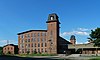 | November 18, 1983 (#83003809) | Roughly bounded by Lonsdale Avenue, Rand and Pine Streets. 41°52′51″N 71°23′53″W / 41.880833°N 71.398056°W / 41.880833; -71.398056 (Conant Thread-Coats & Clark Mill Complex District) | Central Falls | Extends into Pawtucket |
| 42 | Amos Cooke House |  | October 30, 1979 (#79000054) | Chopmist Hill Rd. 41°48′31″N 71°39′41″W / 41.808611°N 71.661389°W / 41.808611; -71.661389 (Amos Cooke House) | Scituate | |
| 43 | Cornell–Randall–Bailey Roadhouse |  | May 10, 1984 (#84001943) | 2737 Hartford Ave. 41°49′57″N 71°33′29″W / 41.8325°N 71.558056°W / 41.8325; -71.558056 (Cornell–Randall–Bailey Roadhouse) | Johnston | |
| 44 | Crescent Park Looff Carousel |  | April 21, 1976 (#76000045) | Riverside Park 41°45′24″N 71°21′34″W / 41.756594°N 71.359431°W / 41.756594; -71.359431 (Crescent Park Looff Carousel) | East Providence | Restored 1895 carousel features some of Charles I.D. Looff's finest workmanship |
| 45 | Cumberland Town Hall Historic District |  | October 21, 2019 (#100004532) | 45 Broad St. and 16 Mill St. 41°54′01″N 71°23′27″W / 41.9003°N 71.3907°W / 41.9003; -71.3907 (Cumberland Town Hall Historic District) | Cumberland | |
| 46 | Nathaniel Daggett House |  | November 28, 1980 (#80000092) | 74 Roger Williams Ave. 41°50′16″N 71°21′46″W / 41.837778°N 71.362778°W / 41.837778; -71.362778 (Nathaniel Daggett House) | East Providence | |
| 47 | James Dennis House |  | November 28, 1980 (#80000095) | 3120 Pawtucket Ave. 41°47′21″N 71°21′53″W / 41.789167°N 71.364722°W / 41.789167; -71.364722 (James Dennis House) | East Providence | |
| 48 | District 6 Schoolhouse | 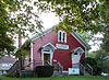 | November 28, 1980 (#80000096) | 347 Willett Ave 41°46′23″N 71°21′19″W / 41.773056°N 71.355278°W / 41.773056; -71.355278 (District 6 Schoolhouse) | East Providence | |
| 49 | Capt. George Dorrance House |  | March 16, 1972 (#72000039) | 2 Jencks Rd. 41°44′22″N 71°47′12″W / 41.739444°N 71.786667°W / 41.739444; -71.786667 (Capt. George Dorrance House) | Foster | |
| 50 | Double L Site, RI-958 | Upload image | September 12, 1985 (#85002362) | Address Restricted | Scituate | |
| 51 | Eddy Homestead | 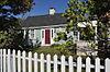 | August 13, 1986 (#86001511) | 2543 Hartford Ave. 41°49′57″N 71°32′56″W / 41.8325°N 71.548889°W / 41.8325; -71.548889 (Eddy Homestead) | Johnston | |
| 52 | Edgewood Historic District–Aberdeen Plat |  | November 22, 2016 (#16000833) | Berwick Ln., Chiswick Rd., Strathmore Place and Road, portions of Broad St., and Narragansett Blvd., 41°46′13″N 71°23′33″W / 41.770379°N 71.392584°W / 41.770379; -71.392584 (Edgewood Historic District–Aberdeen Plat) | Cranston | |
| 53 | Edgewood Historic District–Anstis Greene Estate Plats |  | August 3, 2015 (#15000497) | Anstis, Broad & Swift Sts., Birchfield & Kensington Rds., Bluff, King, Marion & Rosewood Aves., Narragansett Blvd. 41°46′25″N 71°23′40″W / 41.7737°N 71.3944°W / 41.7737; -71.3944 (Edgewood Historic District–Anstis Greene Estate Plats) | Cranston | |
| 54 | Edgewood Historic District–Arnold Farm Plat |  | September 10, 2010 (#10000733) | Arnold, Albert, Columbia Aves.; parts of Broad St., Pawtuxet Ave., Narragansett Blvd. 41°46′38″N 71°23′44″W / 41.777222°N 71.395556°W / 41.777222; -71.395556 (Edgewood Historic District–Arnold Farm Plat) | Cranston | |
| 55 | Edgewood Historic District–Taft Estate Plat |  | October 24, 2003 (#03001069) | Roughly bounded by Windsor Rd., Narragansett Bay, Circuit Dr., and Broad St.; E. side of Narragansett Blvd. between Windsor Rd. & Ocean Ave. 41°46′14″N 71°23′27″W / 41.770556°N 71.390833°W / 41.770556; -71.390833 (Edgewood Historic District–Taft Estate Plat) | Cranston | Second set of addresses represents a boundary increase, 2014-12-22 |
| 56 | Edgewood Historic District–Sally Greene Homestead Plats | 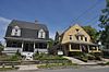 | November 22, 2016 (#16000787) | Fairview and Glen Aves., Harbour Terr., Hudson Pl., Massasoit Ave., and portions of Broad St. & Narragansett Blvd, 41°46′22″N 71°23′31″W / 41.772675°N 71.392016°W / 41.772675; -71.392016 (Edgewood Historic District–Sally Greene Homestead Plats) | Cranston | |
| 57 | Edgewood Historic District–Shaw Plat |  | March 27, 2013 (#13000120) | Shaw and Marion Aves., parts of Narragansett Boulevard, and Broad St. 41°46′30″N 71°23′41″W / 41.775088°N 71.394829°W / 41.775088; -71.394829 (Edgewood Historic District–Shaw Plat) | Cranston | |
| 58 | Edgewood Yacht Club |  | February 23, 1989 (#89000072) | 3 Shaw Ave. 41°46′34″N 71°23′26″W / 41.776111°N 71.390556°W / 41.776111; -71.390556 (Edgewood Yacht Club) | Cranston | |
| 59 | Elliot–Harris–Miner House |  | August 30, 1984 (#84001984) | 1406 Old Louisquisset Pike 41°52′43″N 71°26′11″W / 41.878611°N 71.436389°W / 41.878611; -71.436389 (Elliot–Harris–Miner House) | Lincoln | |
| 60 | Elm Tree Plat Historic District |  | November 19, 2015 (#15000829) | Charlotte & Elinora Sts., Fenner, Harvey & Willett Aves. 41°46′13″N 71°21′10″W / 41.7702°N 71.3528°W / 41.7702; -71.3528 (Elm Tree Plat Historic District) | East Providence | |
| 61 | Esten–Bowen House |  | December 30, 2011 (#11000978) | 299 Iron Mine Rd. 42°00′17″N 71°38′17″W / 42.00479°N 71.637936°W / 42.00479; -71.637936 (Esten–Bowen House) | Burrillville | |
| 62 | David G. Fales House |  | April 6, 1979 (#79000006) | 476 High St. 41°53′10″N 71°23′05″W / 41.886111°N 71.384722°W / 41.886111; -71.384722 (David G. Fales House) | Central Falls | |
| 63 | Edwin H. Farnum House |  | May 17, 1974 (#74000359) | U.S. Route 44 at its junction with Collins St. 41°51′46″N 71°29′39″W / 41.862778°N 71.494167°W / 41.862778; -71.494167 (Edwin H. Farnum House) | Johnston | |
| 64 | Thomas Fenner House |  | March 2, 1990 (#90000143) | 43 Stony Acre Dr. 41°47′27″N 71°29′19″W / 41.790833°N 71.488611°W / 41.790833; -71.488611 (Thomas Fenner House) | Cranston | |
| 65 | Forestdale Mill Village Historic District |  | June 5, 1972 (#72000041) | East and west along Main St. and north on Maple Ave. 41°59′51″N 71°33′50″W / 41.9975°N 71.563889°W / 41.9975; -71.563889 (Forestdale Mill Village Historic District) | North Smithfield | |
| 66 | Foster Center Historic District |  | May 11, 1974 (#74000050) | Foster 41°47′07″N 71°43′18″W / 41.785278°N 71.721667°W / 41.785278; -71.721667 (Foster Center Historic District) | Foster | |
| 67 | Furnace Carolina Site |  | May 10, 1993 (#93000341) | Address Restricted | Cumberland | |
| 68 | Furnace Hill Brook Historic and Archeological District |  | August 6, 1980 (#80000097) | off Furnace Hill Road 41°45′20″N 71°29′15″W / 41.755483°N 71.487595°W / 41.755483; -71.487595 (Furnace Hill Brook Historic and Archeological District) | Cranston | |
| 69 | Georgiaville Historic District |  | October 3, 1985 (#85002734) | Roughly bounded by Stillwater Rd., Cross St., Whipple Ave., and Farnum Pike 41°53′18″N 71°30′26″W / 41.888333°N 71.507222°W / 41.888333; -71.507222 (Georgiaville Historic District) | Smithfield | |
| 70 | Glocester Town Pound |  | September 22, 1970 (#70000021) | Pound Rd. and Chopmist Hill Rd. 41°53′44″N 71°40′09″W / 41.895556°N 71.669167°W / 41.895556; -71.669167 (Glocester Town Pound) | Glocester | |
| 71 | Great Road Historic District |  | July 22, 1974 (#74000051) | Great Rd. 41°54′21″N 71°25′41″W / 41.905833°N 71.428056°W / 41.905833; -71.428056 (Great Road Historic District) | Lincoln | |
| 72 | Benjamin F. Greene House |  | April 6, 1979 (#79000007) | 85 Cross St. 41°53′08″N 71°23′11″W / 41.885556°N 71.386389°W / 41.885556; -71.386389 (Benjamin F. Greene House) | Central Falls | |
| 73 | Greystone Historic District |  | January 2, 2008 (#07001343) | 1-16 Beckside Rd., 1-29 Greystone Ave., 1-24 Oakleigh Ave., 1-40 Langsberries Ave., 2-20 Larchmount Ave N, 1-16 S... 41°52′02″N 71°29′24″W / 41.867222°N 71.49°W / 41.867222; -71.49 (Greystone Historic District) | North Providence and Johnston | Mill complex and associated village and housing area |
| 74 | Greystone Mill Historic District |  | April 28, 2004 (#04000378) | Greystone Ave. 41°51′53″N 71°29′28″W / 41.864722°N 71.491111°W / 41.864722; -71.491111 (Greystone Mill Historic District) | North Providence and Johnston | Mill complex along the Woonasquatucket River |
| 75 | Harmony Chapel and Cemetery |  | June 25, 1980 (#80000098) | Putnam Pike 41°53′20″N 71°36′03″W / 41.888889°N 71.600833°W / 41.888889; -71.600833 (Harmony Chapel and Cemetery) | Glocester | |
| 76 | Harrisville Historic District |  | March 21, 1984 (#84002010) | Roughly bounded by Wood and Sherman Rds., East Ave, and Main, Chapel, School, and River Sts. 41°57′59″N 71°40′33″W / 41.966389°N 71.675833°W / 41.966389; -71.675833 (Harrisville Historic District) | Burrillville | |
| 77 | Hearthside |  | April 24, 1973 (#73000069) | Great Rd. 41°54′23″N 71°25′50″W / 41.906389°N 71.430556°W / 41.906389; -71.430556 (Hearthside) | Lincoln | |
| 78 | Holy Trinity Church Complex |  | January 3, 1978 (#78000073) | 134 Fuller Ave. 41°53′19″N 71°23′47″W / 41.888611°N 71.396389°W / 41.888611; -71.396389 (Holy Trinity Church Complex) | Central Falls | Church demolished; only the parish house is extant. |
| 79 | Hope Village Historic District |  | August 8, 1995 (#95000918) | Roughly bounded by the Pawtuxet River, Hope Furnace Rd., Hope Mill Pond, North Rd., White Ln., and Harrington and Potter Sts. 41°44′00″N 71°33′45″W / 41.733333°N 71.5625°W / 41.733333; -71.5625 (Hope Village Historic District) | Scituate | |
| 80 | Thomas H. Hughes House |  | June 15, 1979 (#79000056) | 423 Central Ave. 41°48′28″N 71°29′51″W / 41.807778°N 71.4975°W / 41.807778; -71.4975 (Thomas H. Hughes House) | Johnston | |
| 81 | Jenckes House | 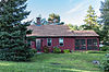 | August 30, 1984 (#84002019) | 81 Jenckes Hill Rd. 41°54′16″N 71°27′32″W / 41.904444°N 71.458889°W / 41.904444; -71.458889 (Jenckes House) | Lincoln | |
| 82 | Jenckes House |  | October 10, 1984 (#84000088) | 1730 Old Louisquisset Pike 41°53′44″N 71°26′55″W / 41.895556°N 71.448611°W / 41.895556; -71.448611 (Jenckes House) | Lincoln | |
| 83 | Jenks Park & Cogswell Tower |  | April 6, 1979 (#79000057) | Adjoining 580 Broad St. 41°53′15″N 71°23′21″W / 41.8875°N 71.389167°W / 41.8875; -71.389167 (Jenks Park & Cogswell Tower) | Central Falls | |
| 84 | Luke Jillson House |  | August 12, 1982 (#82000141) | 2510 Mendon Rd. 41°57′41″N 71°26′41″W / 41.961389°N 71.444722°W / 41.961389; -71.444722 (Luke Jillson House) | Cumberland | |
| 85 | Joy Homestead | 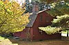 | February 18, 1971 (#71000035) | 156 Scituate Ave. 41°46′57″N 71°28′36″W / 41.7825°N 71.476667°W / 41.7825; -71.476667 (Joy Homestead) | Cranston | |
| 86 | Knightsville Meetinghouse |  | March 8, 1978 (#78000074) | 67 Phenix Ave. 41°46′54″N 71°28′08″W / 41.781667°N 71.468889°W / 41.781667; -71.468889 (Knightsville Meetinghouse) | Cranston | |
| 87 | Lime Kilns |  | August 30, 1984 (#84002015) | Off Louisquisset Pike, Sherman Ave., and Dexter Rock Rds. | Lincoln | Ruined remnants of three colonial-era lime kilns at different locations. |
| 88 | Limerock Village Historic District | 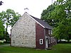 | May 23, 1974 (#74000052) | In an irregular pattern along Smith, Wilbur, and Great Rds., and Old Louisquisset Pike 41°55′40″N 71°27′22″W / 41.927778°N 71.456111°W / 41.927778; -71.456111 (Limerock Village Historic District) | Lincoln | |
| 89 | Lippitt Hill Historic District |  | March 2, 1989 (#89000142) | Hope Rd., Burlingame Rd., and Lippett Ave. 41°44′23″N 71°32′06″W / 41.739722°N 71.535°W / 41.739722; -71.535 (Lippitt Hill Historic District) | Cranston | |
| 90 | Little Neck Cemetery |  | November 28, 1980 (#80000100) | Off Read St. 41°45′59″N 71°21′18″W / 41.766389°N 71.355°W / 41.766389; -71.355 (Little Neck Cemetery) | East Providence | |
| 91 | Lonsdale Historic District |  | May 25, 1984 (#84002022) | Lonsdale Ave., Blackstone Ct., and Front, Main, Cook, Broad, Mill, Cross and Blackstone Sts. 41°54′34″N 71°24′11″W / 41.909444°N 71.403056°W / 41.909444; -71.403056 (Lonsdale Historic District) | Cumberland and Lincoln | |
| 92 | Lymansville Company Mill |  | December 26, 2012 (#12001098) | 184 Woonasquatucket Ave. 41°50′21″N 71°28′32″W / 41.839194°N 71.475466°W / 41.839194; -71.475466 (Lymansville Company Mill) | North Providence | |
| 93 | Manton–Hunt–Farnum Farm |  | October 3, 1985 (#85002735) | Putnam Pike 41°53′54″N 71°37′15″W / 41.898333°N 71.620833°W / 41.898333; -71.620833 (Manton–Hunt–Farnum Farm) | Glocester | |
| 94 | Manville Company Worker Housing Historic District | 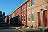 | April 2, 2009 (#08001183) | Bounded by Chestnut St., Angle St., Railroad St., Winter St., Fall St., Spring St., Park Way, Almeida Dr., and Main St. 41°58′13″N 71°28′18″W / 41.970278°N 71.471667°W / 41.970278; -71.471667 (Manville Company Worker Housing Historic District) | Lincoln | |
| 95 | Mathewson Farm |  | January 26, 2001 (#01000019) | 544 Greenville Ave. 41°50′44″N 71°30′16″W / 41.845556°N 71.504444°W / 41.845556; -71.504444 (Mathewson Farm) | Johnston | |
| 96 | McGonagle Site, RI-1227 | Upload image | September 12, 1985 (#85002400) | Address Restricted | Scituate | |
| 97 | Metcalf–Franklin Farm |  | June 7, 2007 (#07000526) | 142 Abbott Run Valley Rd. 41°57′56″N 71°23′37″W / 41.965622°N 71.393511°W / 41.965622; -71.393511 (Metcalf–Franklin Farm) | Cumberland | |
| 98 | Millrace Site, RI-1039 | Upload image | September 12, 1985 (#85002361) | Address Restricted | Scituate | |
| 99 | Moosup Valley Historic District | 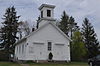 | May 11, 1988 (#88000521) | Roughly bounded by Harrington, Johnson, Moosup Valley and Barb Hill, and Cucumber Hill Rds. 41°44′25″N 71°45′23″W / 41.740278°N 71.756389°W / 41.740278; -71.756389 (Moosup Valley Historic District) | Foster | |
| 100 | Moswansicut Pond Site, RI-960 | Upload image | September 12, 1985 (#85002363) | Address Restricted | Scituate | |
| 101 | Mt. Hygeia |  | August 12, 1977 (#77000008) | Mt. Hygeia Rd. 41°50′48″N 71°45′17″W / 41.846667°N 71.754722°W / 41.846667; -71.754722 (Mt. Hygeia) | Foster | Also known as the Solomon Drown House. |
| 102 | Mount Vernon Tavern |  | May 8, 1974 (#74000001) | 199 Plainfield Pike (RI 14) 41°43′51″N 71°42′52″W / 41.730833°N 71.714444°W / 41.730833; -71.714444 (Mount Vernon Tavern) | Foster | |
| 103 | Tyler Mowry House |  | August 16, 1996 (#96000904) | 112 Sayles Hill Rd. 41°57′53″N 71°30′18″W / 41.964722°N 71.505°W / 41.964722; -71.505 (Tyler Mowry House) | North Smithfield | |
| 104 | William Mowry House |  | February 10, 1983 (#83000001) | Farnum Pike 41°56′52″N 71°33′33″W / 41.947778°N 71.559167°W / 41.947778; -71.559167 (William Mowry House) | North Smithfield | |
| 105 | Naushon Company Plant |  | December 13, 2016 (#16000854) | 32 Meeting St. 41°53′58″N 71°23′32″W / 41.899314°N 71.392193°W / 41.899314; -71.392193 (Naushon Company Plant) | Cumberland | |
| 106 | Newman Cemetery |  | November 28, 1980 (#80000002) | Newman and Pawtucket Aves. 41°50′22″N 71°21′04″W / 41.839444°N 71.351111°W / 41.839444; -71.351111 (Newman Cemetery) | East Providence | |
| 107 | Newman Congregational Church |  | November 28, 1980 (#80000003) | 100 Newman Ave. 41°50′28″N 71°21′03″W / 41.841111°N 71.350833°W / 41.841111; -71.350833 (Newman Congregational Church) | East Providence | |
| 108 | Hopkins Mill Historic District |  | May 10, 1984 (#84002013) | Old Danielson Pike, U.S. Route 6, Maple Rock and Rams Trail Rds. 41°49′21″N 71°42′25″W / 41.8225°N 71.706944°W / 41.8225; -71.706944 (Hopkins Mill Historic District) | Foster | Misspelled "Nopkins" in the National Register |
| 109 | Norwood Avenue Historic District |  | April 26, 2002 (#02000412) | Roughly along Norwood Ave. between Roger Williams to Broad St. 41°46′51″N 71°24′12″W / 41.780833°N 71.403333°W / 41.780833; -71.403333 (Norwood Avenue Historic District) | Cranston | Extends into Providence. |
| 110 | Oak Lawn Village Historic District |  | November 25, 1977 (#77000004) | Wilbur Ave. from Natick Rd. to Oaklawn Ave., includes Searle, Exchange, and Wheelock Sts. 41°44′57″N 71°29′06″W / 41.749167°N 71.485°W / 41.749167; -71.485 (Oak Lawn Village Historic District) | Cranston | |
| 111 | Oakland Historic District | 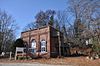 | September 9, 1987 (#87001359) | Victory Highway 41°57′32″N 71°38′47″W / 41.958889°N 71.646389°W / 41.958889; -71.646389 (Oakland Historic District) | Burrillville | |
| 112 | Ochee Spring Quarry |  | May 5, 1978 (#78000003) | Behind 767 Hartford Ave[6] 41°49′14″N 71°28′17″W / 41.820487°N 71.471441°W / 41.820487; -71.471441 (Ochee Spring Quarry) | Johnston | This site has been significantly encroached on by local development. |
| 113 | Oddfellow's Hall |  | November 28, 1980 (#80000004) | 63-67 Warren Ave. 41°49′01″N 71°22′56″W / 41.816944°N 71.382222°W / 41.816944; -71.382222 (Oddfellow's Hall) | East Providence | |
| 114 | Old Ashton Historic District |  | August 30, 1984 (#84002037) | Lower River Rd. and Blackstone Canal Towpath 41°56′11″N 71°26′04″W / 41.936389°N 71.434444°W / 41.936389; -71.434444 (Old Ashton Historic District) | Lincoln | Now a site on the Blackstone River Bikeway State Park |
| 115 | Old Congregational Church |  | January 11, 1974 (#74000002) | Off U.S. Route 6 on Greenville Rd. (RI 116) 41°50′03″N 71°35′14″W / 41.834167°N 71.587222°W / 41.834167; -71.587222 (Old Congregational Church) | Scituate | |
| 116 | Capt. Stephen Olney House |  | May 1, 1974 (#74000003) | 138 Smithfield Rd. 41°51′19″N 71°27′05″W / 41.855278°N 71.451389°W / 41.855278; -71.451389 (Capt. Stephen Olney House) | North Providence | |
| 117 | Pascoag Grammar School |  | November 21, 2006 (#06001062) | 265 Sayles Ave. 41°57′46″N 71°42′18″W / 41.962778°N 71.705°W / 41.962778; -71.705 (Pascoag Grammar School) | Burrillville | |
| 118 | Patterson Brothers Commercial Building and House |  | June 10, 1993 (#93000502) | 157, 159, and 161 Broad St. 41°54′10″N 71°23′32″W / 41.902778°N 71.392222°W / 41.902778; -71.392222 (Patterson Brothers Commercial Building and House) | Cumberland | Demolished 1998. Hardware store stands on the site.[7] |
| 119 | Pawtuxet Village Historic District |  | April 24, 1973 (#73000050) | Bounded roughly by Bayside, S. Atlantic, and Ocean Aves., the Pawtuxet and Providence rivers, and Post Rd. 41°45′49″N 71°23′27″W / 41.763611°N 71.390833°W / 41.763611; -71.390833 (Pawtuxet Village Historic District) | Cranston | |
| 120 | Phillipsdale Historic District |  | September 15, 2011 (#11000675) | Roughly bounded by Seekonk River, Roger Williams Ave. & Ruth Ave. 41°50′52″N 71°21′55″W / 41.847778°N 71.365278°W / 41.847778; -71.365278 (Phillipsdale Historic District) | East Providence | |
| 121 | Pocasset Worsted Company Mill |  | July 19, 2010 (#10000471) | 75 Pocasset St. 41°47′50″N 71°28′34″W / 41.797222°N 71.476111°W / 41.797222; -71.476111 (Pocasset Worsted Company Mill) | Johnston | |
| 122 | Pomham Rocks Light Station |  | July 9, 1979 (#79000001) | Riverside Rd. 41°46′40″N 71°22′13″W / 41.777778°N 71.370278°W / 41.777778; -71.370278 (Pomham Rocks Light Station) | East Providence | |
| 123 | Potter–Remington House | Upload image | December 28, 1978 (#78000006) | 571 Natick Rd. 41°44′30″N 71°29′35″W / 41.741667°N 71.493056°W / 41.741667; -71.493056 (Potter–Remington House) | Cranston | |
| 124 | Pullen Corner School |  | August 30, 1984 (#84002039) | Angell and Whipple 41°53′44″N 71°28′06″W / 41.895556°N 71.468333°W / 41.895556; -71.468333 (Pullen Corner School) | Lincoln | |
| 125 | Rhodes-on-the Pawtuxet Ballroom and Gazebo |  | December 12, 1978 (#78000007) | Rhodes Pl. 41°46′04″N 71°23′32″W / 41.767778°N 71.392222°W / 41.767778; -71.392222 (Rhodes-on-the Pawtuxet Ballroom and Gazebo) | Cranston | |
| 126 | Richmond Paper Company Mill Complex |  | November 1, 2006 (#06000974) | 310 Bourne Ave. 41°50′31″N 71°22′14″W / 41.841944°N 71.370556°W / 41.841944; -71.370556 (Richmond Paper Company Mill Complex) | East Providence | |
| 127 | Rosedale Apartments |  | April 10, 2007 (#07000301) | 1180 Narragansett Boulevard 41°46′57″N 71°23′34″W / 41.7825°N 71.392778°W / 41.7825; -71.392778 (Rosedale Apartments) | Cranston | |
| 128 | Rose Land Park Plat Historic District |  | November 19, 2015 (#15000830) | Florence St., Roseland Ct., Dartmouth, Princeton & Willett Aves. 41°46′09″N 71°21′03″W / 41.7692°N 71.3507°W / 41.7692; -71.3507 (Rose Land Park Plat Historic District) | East Providence | |
| 129 | Rumford Chemical Works and Mill House Historic District |  | November 28, 1980 (#80000007) | N. Broadway, Newman, and Greenwood Aves. 41°50′22″N 71°21′16″W / 41.839444°N 71.354444°W / 41.839444; -71.354444 (Rumford Chemical Works and Mill House Historic District) | East Providence | |
| 130 | Rumford Historic District |  | November 28, 1980 (#80000008) | Pleasant St. and Greenwood and Pawtucket Aves 41°49′50″N 71°20′55″W / 41.830556°N 71.348611°W / 41.830556; -71.348611 (Rumford Historic District) | East Providence | Boundary changes approved August 6, 2018 |
| 131 | St. Joseph's Church Complex |  | August 12, 1982 (#82000007) | 1303–1317 Mendon Rd. 41°56′03″N 71°25′40″W / 41.934167°N 71.427778°W / 41.934167; -71.427778 (St. Joseph's Church Complex) | Cumberland | |
| 132 | St. Mary's Episcopal Church |  | November 28, 1980 (#80000009) | 83 Warren Ave. 41°49′01″N 71°22′54″W / 41.816944°N 71.381667°W / 41.816944; -71.381667 (St. Mary's Episcopal Church) | East Providence | |
| 133 | St. Matthew's Church |  | April 6, 1979 (#79000008) | Dexter and W. Hunt Sts. 41°53′21″N 71°24′07″W / 41.889167°N 71.401944°W / 41.889167; -71.401944 (St. Matthew's Church) | Central Falls | |
| 134 | Saint Thomas Episcopal Church and Rectory |  | July 2, 1987 (#87000993) | Putnam Pike 41°52′16″N 71°33′12″W / 41.871111°N 71.553333°W / 41.871111; -71.553333 (Saint Thomas Episcopal Church and Rectory) | Smithfield | |
| 135 | Sassafras Site, RI-55 |  | November 1, 1984 (#84000360) | Between Albion Rd. and the Blackstone River[8] 41°57′08″N 71°27′03″W / 41.952222°N 71.450833°W / 41.952222; -71.450833 (Sassafras Site, RI-55) | Lincoln | |
| 136 | Saylesville Historic District |  | August 30, 1984 (#84002049) | Roughly bounded by Memorial Ave., Scotts Road, Industrial Circle, Smithfield Ave., and Woodland Court 41°53′33″N 71°24′37″W / 41.8925°N 71.410278°W / 41.8925; -71.410278 (Saylesville Historic District) | Lincoln | |
| 137 | Saylesville Meetinghouse |  | November 28, 1978 (#78000008) | Smithfield Ave. 41°54′02″N 71°25′06″W / 41.900556°N 71.418333°W / 41.900556; -71.418333 (Saylesville Meetinghouse) | Lincoln | |
| 138 | Second Battle of Nipsachuck Battlefield |  | August 22, 2016 (#16000563) | Address Restricted | North Smithfield | Site of a battle during King Philip's War. |
| 139 | Sheldon House |  | January 5, 1989 (#88001123) | 458 Scituate Ave. 41°46′47″N 71°29′33″W / 41.779722°N 71.4925°W / 41.779722; -71.4925 (Sheldon House) | Cranston | |
| 140 | Slatersville Historic District |  | April 24, 1973 (#73000002) | Main, Green, Church, and School Sts. and Ridge Rd. 41°59′53″N 71°34′57″W / 41.998056°N 71.5825°W / 41.998056; -71.5825 (Slatersville Historic District) | North Smithfield | |
| 141 | Joseph Smith House |  | November 28, 1978 (#78000009) | 109 Smithfield Rd. 41°51′22″N 71°27′00″W / 41.856111°N 71.45°W / 41.856111; -71.45 (Joseph Smith House) | North Providence | |
| 142 | Smith–Appleby House |  | May 1, 1974 (#74000005) | Stillwater Rd. southeast of its junction with Capron Rd. 41°54′07″N 71°31′06″W / 41.901944°N 71.518333°W / 41.901944; -71.518333 (Smith–Appleby House) | Smithfield | |
| 143 | Smithfield Exchange Bank | 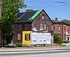 | April 19, 2006 (#06000295) | 599 Putnam Pike 41°52′26″N 71°33′12″W / 41.873889°N 71.553333°W / 41.873889; -71.553333 (Smithfield Exchange Bank) | Smithfield | |
| 144 | Smithfield Road Historic District |  | February 18, 1987 (#87000036) | Old Smithfield Rd., just north of Sayles Hill Road 41°58′02″N 71°29′34″W / 41.967222°N 71.492778°W / 41.967222; -71.492778 (Smithfield Road Historic District) | North Smithfield | |
| 145 | Smithville Seminary |  | March 29, 1978 (#78003446) | Institute Lane 41°50′02″N 71°35′00″W / 41.833889°N 71.583333°W / 41.833889; -71.583333 (Smithville Seminary) | Scituate | |
| 146 | Smithville – North Scituate |  | August 29, 1979 (#79000003) | Danielson Pike and W. Greenville Road 41°50′00″N 71°35′07″W / 41.833333°N 71.585278°W / 41.833333; -71.585278 (Smithville – North Scituate) | Scituate | |
| 147 | South Central Falls Historic District |  | January 31, 1991 (#91000025) | Roughly bounded by the Central Falls-Pawtucket boundary and Rand, Summit, Dexter and Broad Sts. 41°53′04″N 71°23′28″W / 41.884444°N 71.391111°W / 41.884444; -71.391111 (South Central Falls Historic District) | Central Falls | |
| 148 | Gov. William Sprague Mansion |  | February 18, 1971 (#71000002) | 1351 Cranston St. 41°47′28″N 71°27′24″W / 41.791111°N 71.456667°W / 41.791111; -71.456667 (Gov. William Sprague Mansion) | Cranston | |
| 149 | Squantum Association |  | November 28, 1980 (#80000010) | 947 Veterans Memorial Parkway 41°47′24″N 71°22′25″W / 41.79°N 71.373611°W / 41.79; -71.373611 (Squantum Association) | East Providence | |
| 150 | Ira B. Sweet House |  | January 15, 2010 (#08000715) | 38 Esmond St. 41°52′31″N 71°30′13″W / 41.875369°N 71.503639°W / 41.875369; -71.503639 (Ira B. Sweet House) | Smithfield | |
| 151 | Moses Taft House | 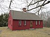 | March 20, 2009 (#08000718) | 111 East Wallum Lake Road 41°57′59″N 71°43′02″W / 41.966389°N 71.717361°W / 41.966389; -71.717361 (Moses Taft House) | Burrillville | |
| 152 | Three Dog Site, RI-151 |  | November 1, 1984 (#84000362) | Off Routes 5/104 near the Smithfield line[9] | North Smithfield | |
| 153 | Todd Farm | 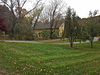 | February 10, 1983 (#83000004) | 670 Farnum Pike 41°57′57″N 71°32′26″W / 41.965833°N 71.540556°W / 41.965833; -71.540556 (Todd Farm) | North Smithfield | |
| 154 | Lewis Tower House | 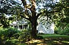 | August 30, 1982 (#82000010) | 2199 Mendon Rd. 41°57′14″N 71°26′33″W / 41.953889°N 71.4425°W / 41.953889; -71.4425 (Lewis Tower House) | Cumberland | |
| 155 | Tower–Flagg Barn Complex | Upload image | May 20, 1998 (#98000574) | 100 Abbott Run Valley Rd. 41°57′33″N 71°23′34″W / 41.959167°N 71.392778°W / 41.959167; -71.392778 (Tower–Flagg Barn Complex) | Cumberland | Demolished and replaced by housing development. |
| 156 | Union Village Historic District | 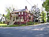 | July 28, 1978 (#78000011) | West of Woonsocket on RI 146A 41°59′28″N 71°32′13″W / 41.991111°N 71.536944°W / 41.991111; -71.536944 (Union Village Historic District) | North Smithfield | |
| 157 | Valley Falls Mill | 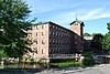 | April 26, 1978 (#78000012) | 1359 and 1361-63 Broad St. 41°53′55″N 71°23′20″W / 41.898611°N 71.388889°W / 41.898611; -71.388889 (Valley Falls Mill) | Central Falls | Boundary increase December 18, 1978. |
| 158 | Phillip Walker House |  | June 24, 1972 (#72000006) | 432 W. Massasoit Ave. 41°49′49″N 71°21′50″W / 41.830278°N 71.363889°W / 41.830278; -71.363889 (Phillip Walker House) | East Providence | |
| 159 | Waterman–Winsor Farm |  | June 27, 1980 (#80000012) | 79 Austin Ave. 41°52′55″N 71°33′45″W / 41.881944°N 71.5625°W / 41.881944; -71.5625 (Waterman–Winsor Farm) | Smithfield | |
| 160 | Westcote |  | August 3, 1988 (#88001126) | 101 Mountain Laurel Dr. 41°45′19″N 71°28′21″W / 41.755278°N 71.4725°W / 41.755278; -71.4725 (Westcote) | Cranston | |
| 161 | Nathan Westcott House | 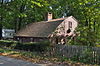 | January 5, 1989 (#88001124) | 150 Scituate Ave. 41°46′42″N 71°28′46″W / 41.778333°N 71.479444°W / 41.778333; -71.479444 (Nathan Westcott House) | Cranston | |
| 162 | Whipple–Angell–Bennett House |  | July 28, 1995 (#95000917) | 157 Olney Ave. 41°50′57″N 71°27′54″W / 41.849167°N 71.465°W / 41.849167; -71.465 (Whipple–Angell–Bennett House) | North Providence | |
| 163 | Whipple–Cullen House and Barn |  | November 14, 1991 (#91001647) | Old River Rd. south of its junction with George Washington Highway 41°55′49″N 71°26′31″W / 41.930278°N 71.441944°W / 41.930278; -71.441944 (Whipple–Cullen House and Barn) | Lincoln | |
| 164 | Whipple–Jenckes House |  | November 5, 1992 (#92001541) | 8 Fairhaven Road 41°57′25″N 71°24′02″W / 41.957057°N 71.400437°W / 41.957057; -71.400437 (Whipple–Jenckes House) | Cumberland | |
| 165 | Whitcomb Farm |  | November 28, 1980 (#80000013) | 36 Willett Ave. 41°46′37″N 71°21′45″W / 41.776944°N 71.3625°W / 41.776944; -71.3625 (Whitcomb Farm) | East Providence | |
| 166 | Stephen Winsor House |  | October 6, 1975 (#75000004) | 113 Austin Ave. 41°53′08″N 71°33′55″W / 41.885502°N 71.565378°W / 41.885502; -71.565378 (Stephen Winsor House) | Smithfield | Listed at 93 Austin Ave. |
| 167 | Arad Wood House |  | August 3, 1988 (#88001125) | 407 Pontiac Ave. 41°46′30″N 71°26′18″W / 41.775°N 71.438333°W / 41.775; -71.438333 (Arad Wood House) | Cranston | |
| 168 | Woonasquatucket River Site (RI-163) |  | November 1, 1984 (#84000364) | near Farnum Pike[10] 41°54′33″N 71°32′21″W / 41.90924°N 71.539285°W / 41.90924; -71.539285 (Woonasquatucket River Site (RI-163)) | Smithfield | |
| 169 | World War I Memorial |  | October 19, 2001 (#01000466) | Junction of Taunton Ave. and Whelden Ave. 41°49′10″N 71°22′15″W / 41.819444°N 71.370833°W / 41.819444; -71.370833 (World War I Memorial) | East Providence |
See also
Wikimedia Commons has media related to National Register of Historic Places in Providence County, Rhode Island.
- List of National Historic Landmarks in Rhode Island
- National Register of Historic Places listings in Rhode Island
References
- ^ The latitude and longitude information provided in this table was derived originally from the National Register Information System, which has been found to be fairly accurate for about 99% of listings. Some locations in this table may have been corrected to current GPS standards.
- ^ National Park Service, United States Department of the Interior, "National Register of Historic Places: Weekly List Actions", retrieved August 30, 2024.
- ^ Numbers represent an alphabetical ordering by significant words. Various colorings, defined here, differentiate National Historic Landmarks and historic districts from other NRHP buildings, structures, sites or objects.
- ^ "National Register Information System". National Register of Historic Places. National Park Service. March 13, 2009.
- ^ The eight-digit number below each date is the number assigned to each location in the National Register Information System database, which can be viewed by clicking the number.
- ^ RI NRHP property list
- ^ "Broad Street Experience: Central Falls, Pawtucket, Cumberland Rhode Island".
- ^ Barber, Russell J. "Quartz Technology at the Sassafras Site". In Quartz Technology in Prehistoric New England, Russell J. Barber, ed. Cambridge: Peabody Museum, Harvard University, 1981, 53.
- ^ Natural and Cultural Resources - North Smithfield, RI Archived 2015-12-08 at the Wayback Machine
- ^ "Smithfield Reconnaissance Report" (PDF). National Park Service. Retrieved 2013-11-02.
| |||||||||||
|---|---|---|---|---|---|---|---|---|---|---|---|
| Topics |  | ||||||||||
| Lists by county |
| ||||||||||
| Lists by city |
| ||||||||||
| |||||||||||


