National Register of Historic Places listings in San Mateo County, California

This is a list of the National Register of Historic Places listings in San Mateo County, California.
This is intended to be a complete list of the properties and districts on the National Register of Historic Places in San Mateo County, California, United States. Latitude and longitude coordinates are provided for many National Register properties and districts; these locations may be seen together in an online map.[1]
There are 64 properties and districts listed on the National Register in the county, including 2 National Historic Landmarks. Another property was once listed but has been removed.
This National Park Service list is complete through NPS recent listings posted June 7, 2024.[2]
Map all coordinates using OpenStreetMap
Download coordinates as:
- KML
- GPX (all coordinates)
- GPX (primary coordinates)
- GPX (secondary coordinates)
Current listings
| [3] | Name on the Register[4] | Image | Date listed[5] | Location | City or town | Description |
|---|---|---|---|---|---|---|
| 1 | Archeological Site SMA-151 | Upload image | February 23, 1978 (#78000771) | Address Restricted | Princeton | Also known as U.C. Archaeological Research Facility. Native American historical site from 1749-1500 AD and 1499-1000 AD.[6] |
| 2 | Barron-Latham-Hopkins Gate Lodge | 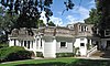 | August 28, 1986 (#86001951) | 555 Ravenswood Ave. 37°27′18″N 122°10′42″W / 37.455°N 122.178333°W / 37.455; -122.178333 (Barron-Latham-Hopkins Gate Lodge) | Menlo Park | |
| 3 | Bourn-Roth Estate |  | August 28, 1975 (#75000479) | 3.7 mi. northwest of Woodside off Canada Rd. 37°28′13″N 122°18′39″W / 37.470278°N 122.310833°W / 37.470278; -122.310833 (Bourn-Roth Estate) | Woodside | Also known as Filoli; built in 1915 by Willis Polk for mining magnate William Bourn, owner of the Empire Mine in Grass Valley, California[7] |
| 4 | Nathanial Brittan Party House |  | December 29, 1994 (#94001500) | 125 Dale Ave. 37°30′02″N 122°16′15″W / 37.500556°N 122.270833°W / 37.500556; -122.270833 (Nathanial Brittan Party House) | San Carlos | |
| 5 | Burlingame Railroad Station |  | April 19, 1978 (#78000769) | Burlingame Ave. and California Dr. 37°34′49″N 122°20′38″W / 37.580278°N 122.343889°W / 37.580278; -122.343889 (Burlingame Railroad Station) | Burlingame | |
| 6 | The Carolands | 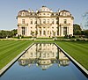 | October 21, 1975 (#75000478) | 565 Remillard Dr. 37°33′20″N 122°22′15″W / 37.555556°N 122.370833°W / 37.555556; -122.370833 (The Carolands) | Hillsborough | 1914 home of Harriet Pullman Carolan, daughter of George Pullman, inventor of the Pullman sleeping car; built by Willis Polk |
| 7 | Casa de Tableta | 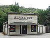 | August 14, 1973 (#73000447) | 3915 Alpine Rd. 37°22′56″N 122°11′34″W / 37.382222°N 122.192778°W / 37.382222; -122.192778 (Casa de Tableta) | Portola Valley | Now Alpine Inn, formerly known as Rossotti's Saloon since the 1850s. |
| 8 | Church of the Nativity |  | October 31, 1980 (#80000855) | 210 Oak Grove Ave. 37°27′39″N 122°10′46″W / 37.460833°N 122.179444°W / 37.460833; -122.179444 (Church of the Nativity) | Menlo Park | |
| 9 | Ernest Coxhead House |  | April 6, 2000 (#00000322) | 37 E. Santa Inez Ave. 37°34′13″N 122°19′54″W / 37.570278°N 122.331667°W / 37.570278; -122.331667 (Ernest Coxhead House) | San Mateo | |
| 10 | Eugene J. de Sabla, Jr., Teahouse and Tea Garden |  | July 30, 1992 (#92000965) | 70 De Sabla Rd. 37°33′55″N 122°19′49″W / 37.565278°N 122.330278°W / 37.565278; -122.330278 (Eugene J. de Sabla, Jr., Teahouse and Tea Garden) | San Mateo | Circa 1907 Japanese farmhouse-style teahouse built for Eugene de Sabla, a co-founder of Pacific Gas and Electric Company[8] |
| 11 | Dickerman Barn |  | January 11, 1982 (#82002259) | Cabrillo Hwy. 37°07′09″N 122°18′21″W / 37.119167°N 122.305833°W / 37.119167; -122.305833 (Dickerman Barn) | Pescadero | |
| 12 | John Dielmann House | Upload image | October 6, 2015 (#15000681) | 1020 Main St. 37°29′01″N 122°13′34″W / 37.4836°N 122.2261°W / 37.4836; -122.2261 (John Dielmann House) | Redwood City | |
| 13 | First Congregational Church of Pescadero | 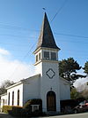 | October 31, 1980 (#80000856) | San Gregorio St. 37°15′16″N 122°22′56″W / 37.254444°N 122.382222°W / 37.254444; -122.382222 (First Congregational Church of Pescadero) | Pescadero | |
| 14 | Folger Estate Stable Historic District |  | April 16, 2004 (#04000328) | 4040 Woodside Rd. 37°24′30″N 122°15′29″W / 37.408333°N 122.258056°W / 37.408333; -122.258056 (Folger Estate Stable Historic District) | Woodside | |
| 15 | Golden Gate National Cemetery |  | March 8, 2016 (#16000058) | 1300 Sneath Ln. 37°38′07″N 122°25′52″W / 37.635278°N 122.431111°W / 37.635278; -122.431111 (Golden Gate National Cemetery) | San Bruno | |
| 16 | Mortimer Fleishhacker House | 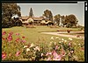 | September 26, 1986 (#86002396) | 329 Albion Avenue 37°25′59″N 122°16′02″W / 37.433056°N 122.267222°W / 37.433056; -122.267222 (Mortimer Fleishhacker House) | Woodside | An English style vacation home designed by Charles Sumner Greene circa.1911, also known as Green Gables.[9] |
| 17 | Green Oaks Ranch House | Upload image | November 21, 1976 (#76000526) | 13 mi. S of Pescadero on CA 1 37°08′04″N 122°18′38″W / 37.134444°N 122.310556°W / 37.134444; -122.310556 (Green Oaks Ranch House) | Pescadero | also known as the Isaac Steele Ranch. |
| 18 | Arthur and Mona Hofmann House |  | August 5, 1991 (#91000926) | 1048 La Cuesta Rd. 37°33′03″N 122°20′53″W / 37.550833°N 122.348056°W / 37.550833; -122.348056 (Arthur and Mona Hofmann House) | Hillsborough | |
| 19 | Holbrook-Palmer Estate |  | September 26, 2016 (#16000663) | 150 Watkins Ave. 37°27′49″N 122°11′29″W / 37.463654°N 122.191419°W / 37.463654; -122.191419 (Holbrook-Palmer Estate) | Atherton | This estate is also known as "Elmwood". |
| 20 | Hotel St. Matthew | 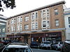 | January 23, 1998 (#97001663) | 215-229 Second Ave. 37°33′58″N 122°19′26″W / 37.566111°N 122.323889°W / 37.566111; -122.323889 (Hotel St. Matthew) | San Mateo | |
| 21 | Howard-Ralston Eucalyptus Tree Rows | 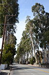 | March 15, 2012 (#12000127) | El Camino Real, CA 82 37°34′54″N 122°21′43″W / 37.581725°N 122.361996°W / 37.581725; -122.361996 (Howard-Ralston Eucalyptus Tree Rows) | Burlingame | |
| 22 | Independence Hall |  | August 3, 1978 (#78000772) | 2955 Woodside Rd. 37°25′43″N 122°15′37″W / 37.428644°N 122.260325°W / 37.428644; -122.260325 (Independence Hall) | Woodside | 1884 building that was located at 129 Albion Ave. when added to the National Register. It is now located adjacent to Woodside Town Hall at 2955 Woodside Rd.[10] |
| 23 | James Johnston House |  | May 9, 1973 (#73000446) | Higgins-Purisima Rd. 37°26′59″N 122°25′20″W / 37.449722°N 122.422222°W / 37.449722; -122.422222 (James Johnston House) | Half Moon Bay | |
| 24 | Kohl Mansion |  | February 3, 1982 (#82002258) | 2750 Adeline Dr. 37°34′57″N 122°22′55″W / 37.5825°N 122.381944°W / 37.5825; -122.381944 (Kohl Mansion) | Burlingame | |
| 25 | Lathrop House |  | April 11, 1973 (#73000448) | 701 Hamilton St. 37°29′16″N 122°13′48″W / 37.4879°N 122.2301°W / 37.4879; -122.2301 (Lathrop House) | Redwood City | |
| 26 | Martin Building |  | February 14, 1997 (#97000043) | 220 Linden Ave.[11] 37°39′18″N 122°24′32″W / 37.655°N 122.4089°W / 37.655; -122.4089 (Martin Building) | South San Francisco | Now known as the Metropolitan Hotel, a residential hotel |
| 27 | Arthur C. and Judith Mathews House | Upload image | December 7, 2021 (#100007224) | 83 Wisteria Way 37°28′19″N 122°10′29″W / 37.4719°N 122.1746°W / 37.4719; -122.1746 (Arthur C. and Judith Mathews House) | Atherton | |
| 28 | Menlo Park Railroad Station |  | October 1, 1974 (#74000556) | 1100 Merrill St. 37°27′16″N 122°10′51″W / 37.454444°N 122.180833°W / 37.454444; -122.180833 (Menlo Park Railroad Station) | Menlo Park | |
| 29 | Methodist Episcopal Church at Half Moon Bay |  | November 10, 1980 (#80000854) | 777 Miramontes St. 37°27′46″N 122°25′37″W / 37.462778°N 122.426944°W / 37.462778; -122.426944 (Methodist Episcopal Church at Half Moon Bay) | Half Moon Bay | |
| 30 | Methodist Episcopal Church of Pescadero |  | March 10, 1982 (#82002260) | 108 San Gregorio St. 37°15′05″N 122°22′54″W / 37.251389°N 122.381667°W / 37.251389; -122.381667 (Methodist Episcopal Church of Pescadero) | Pescadero | |
| 31 | Robert Mills Dairy Barn |  | February 15, 1990 (#90000120) | Higgins Purissima Rd. 37°27′20″N 122°23′18″W / 37.455556°N 122.388333°W / 37.455556; -122.388333 (Robert Mills Dairy Barn) | Half Moon Bay | |
| 32 | National Bank of San Mateo |  | April 24, 1997 (#97000331) | 164 S. B St. 37°34′00″N 122°19′20″W / 37.566667°N 122.322222°W / 37.566667; -122.322222 (National Bank of San Mateo) | San Mateo | |
| 33 | New Sequoia Theater Building | 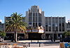 | May 5, 1994 (#94000431) | 2211-2235 Broadway 37°29′11″N 122°13′47″W / 37.486389°N 122.229722°W / 37.486389; -122.229722 (New Sequoia Theater Building) | Redwood City | |
| 34 | Newhall Estate | 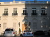 | April 13, 2007 (#07000308) | 1761 Manor Dr. 37°34′42″N 122°21′39″W / 37.578333°N 122.360833°W / 37.578333; -122.360833 (Newhall Estate) | Hillsborough | |
| 35 | John Offerman House | Upload image | October 5, 2015 (#15000682) | 1018 Main St. 37°29′02″N 122°13′34″W / 37.4838°N 122.2261°W / 37.4838; -122.2261 (John Offerman House) | Redwood City | |
| 36 | Our Lady of the Wayside |  | November 22, 1977 (#77000338) | 930 Portola Rd. 37°23′02″N 122°13′58″W / 37.383889°N 122.232778°W / 37.383889; -122.232778 (Our Lady of the Wayside) | Portola Valley | |
| 37 | Pigeon Point Lighthouse | 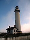 | March 8, 1977 (#77000337) | S of Pescadero at Pigeon Point off CA 1 37°10′54″N 122°23′38″W / 37.181667°N 122.393889°W / 37.181667; -122.393889 (Pigeon Point Lighthouse) | Pescadero | |
| 38 | Pilarcitos Creek Bridge |  | April 7, 2014 (#14000110) | Main St. across Pilarcitos Creek 37°27′58″N 122°25′44″W / 37.466045°N 122.428852°W / 37.466045; -122.428852 (Pilarcitos Creek Bridge) | Half Moon Bay | |
| 39 | Point Montara Light Station | 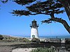 | September 3, 1991 (#91001094) | Jct. of 16th St. and CA 1 37°32′13″N 122°31′05″W / 37.536944°N 122.518056°W / 37.536944; -122.518056 (Point Montara Light Station) | Montara | |
| 40 | POLARIS (research vessel) | Upload image | March 24, 2015 (#15000100) | 597 Seaport Blvd. 37°30′25″N 122°12′43″W / 37.5069°N 122.2119°W / 37.5069; -122.2119 (POLARIS (research vessel)) | Redwood City | |
| 41 | Portola Valley School | 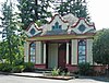 | June 28, 1974 (#74000557) | 775 Portola Rd. 37°22′56″N 122°13′40″W / 37.382222°N 122.227778°W / 37.382222; -122.227778 (Portola Valley School) | Portola Valley | Later used as town hall. |
| 42 | Princeton Hotel |  | January 31, 1979 (#79000543) | Capistrano Rd. and Prospect Way 37°30′18″N 122°29′08″W / 37.505°N 122.4856°W / 37.505; -122.4856 (Princeton Hotel) | Princeton | |
| 43 | William C. Ralston House |  | November 15, 1966 (#66000234) | College of Notre Dame campus 37°31′03″N 122°17′10″W / 37.5175°N 122.2861°W / 37.5175; -122.2861 (William C. Ralston House) | Belmont | |
| 44 | Redwood City Historic Commercial Buildings | 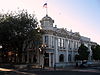 | November 7, 1977 (#77000339) | Broadway and Main Sts. 37°29′12″N 122°13′35″W / 37.4867°N 122.2264°W / 37.4867; -122.2264 (Redwood City Historic Commercial Buildings) | Redwood City | |
| 45 | Redwood City Woman's Club | 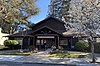 | March 12, 2021 (#100006305) | 149 Clinton St. 37°29′11″N 122°14′23″W / 37.4863°N 122.2396°W / 37.4863; -122.2396 (Redwood City Woman's Club) | Redwood City | |
| 46 | San Francisco Bay Discovery Site |  | May 23, 1968 (#68000022) | Sweeney Ridge; 4 mi. west of San Bruno via Skyline Dr. and Sneath Lane 37°36′16″N 122°27′27″W / 37.6044°N 122.4575°W / 37.6044; -122.4575 (San Francisco Bay Discovery Site) | San Bruno | National Park Service brochure for Sweeney Ridge |
| 47 | San Gregorio House |  | May 6, 1977 (#77000341) | Old Stage Rd. 37°19′35″N 122°23′09″W / 37.3264°N 122.3858°W / 37.3264; -122.3858 (San Gregorio House) | San Gregorio | |
| 48 | San Mateo County Courthouse | 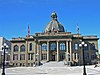 | December 13, 1977 (#77000340) | Broadway 37°29′13″N 122°13′47″W / 37.4869°N 122.2297°W / 37.4869; -122.2297 (San Mateo County Courthouse) | Redwood City | |
| 49 | Sanchez Adobe Park |  | April 13, 1976 (#76000525) | Linda Mar Blvd., 1 mi. E of CA 1 37°35′15″N 122°29′33″W / 37.5875°N 122.4925°W / 37.5875; -122.4925 (Sanchez Adobe Park) | Pacifica | |
| 50 | Sequoia Union High School | 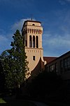 | April 7, 1995 (#95000389) | 1201 Brewster Ave. 37°29′04″N 122°14′09″W / 37.4844°N 122.2358°W / 37.4844; -122.2358 (Sequoia Union High School) | Redwood City | |
| 51 | William Adam Simmons House |  | August 18, 1992 (#92000995) | 751 Kelly Ave. 37°27′49″N 122°25′38″W / 37.4636°N 122.4272°W / 37.4636; -122.4272 (William Adam Simmons House) | Half Moon Bay | |
| 52 | South San Francisco Hillside Sign |  | July 11, 1996 (#96000761) | Sign Hill Park, N of Park Way 37°39′49″N 122°25′08″W / 37.6636°N 122.4189°W / 37.6636; -122.4189 (South San Francisco Hillside Sign) | South San Francisco | |
| 53 | Southern Pacific Depot | 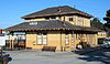 | September 1, 1978 (#78000770) | 21 E. Millbrae Ave. 37°35′56″N 122°23′05″W / 37.5989°N 122.3847°W / 37.5989; -122.3847 (Southern Pacific Depot) | Millbrae | |
| 54 | Southern Pacific Depot |  | September 20, 1984 (#84001191) | 559 El Camino Real 37°30′27″N 122°15′32″W / 37.5075°N 122.2589°W / 37.5075; -122.2589 (Southern Pacific Depot) | San Carlos | |
| 55 | Southern Pacific Railroad Bayshore Roundhouse | 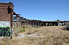 | March 26, 2010 (#10000113) | Junction of Industrial Way and Bayshore Ave. 37°42′04″N 122°24′31″W / 37.7010°N 122.4085°W / 37.7010; -122.4085 (Southern Pacific Railroad Bayshore Roundhouse) | Brisbane | Steam railroad engine roundhouse built between 1907 and 1910 |
| 56 | Timby House | Upload image | May 24, 2024 (#100007818) | 621 Knoll Dr. 37°29′58″N 122°15′53″W / 37.4995°N 122.2647°W / 37.4995; -122.2647 (Timby House) | San Carlos | |
| 57 | Union Cemetery | 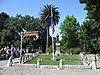 | August 25, 1983 (#83001237) | 316 Woodside Rd. 37°28′26″N 122°13′23″W / 37.4739°N 122.2231°W / 37.4739; -122.2231 (Union Cemetery) | Redwood City | |
| 58 | US Post Main Office-San Mateo |  | April 18, 1988 (#88000443) | 210 S. Ellsworth Ave. 37°34′00″N 122°19′24″W / 37.5667°N 122.3233°W / 37.5667; -122.3233 (US Post Main Office-San Mateo) | San Mateo | |
| 59 | Amelia Vollers House | 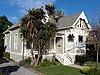 | January 27, 2015 (#14001205) | 353 N. Claremont St. 37°34′27″N 122°19′46″W / 37.5741°N 122.3295°W / 37.5741; -122.3295 (Amelia Vollers House) | San Mateo | |
| 60 | Watkins-Cartan House | 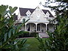 | March 30, 1978 (#78000768) | 98 Alejandra Ave. 37°27′13″N 122°11′49″W / 37.4536°N 122.1969°W / 37.4536; -122.1969 (Watkins-Cartan House) | Atherton | constructed around 1866 for Commodore James Watkins; originally listed as the Commodore James Watkins House; located at 25 Isabella Ave. when listed on the National Register; moved to 98 Alejandra Ave. in 1998[12] |
| 61 | William A. Whifler House | 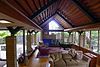 | March 22, 2016 (#16000096) | 1544 Drake Ave. 37°35′14″N 122°22′44″W / 37.5873°N 122.3790°W / 37.5873; -122.3790 (William A. Whifler House) | Burlingame | |
| 62 | Woodside Store | 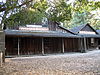 | July 18, 1985 (#85001563) | 471 Kings Mountain Rd. 37°25′49″N 122°16′34″W / 37.4303°N 122.2761°W / 37.4303; -122.2761 (Woodside Store) | Woodside | |
| 63 | X-100 | 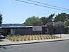 | June 20, 2016 (#16000381) | 1586 Lexington Ave. 37°31′30″N 122°21′12″W / 37.5251°N 122.3532°W / 37.5251; -122.3532 (X-100) | San Mateo | |
| 64 | Yoshiko Yamanouchi House | Upload image | December 26, 2023 (#100009653) | 1007 East 5th Avenue 37°34′07″N 122°18′53″W / 37.5685°N 122.3148°W / 37.5685; -122.3148 (Yoshiko Yamanouchi House) | San Mateo |
Former listing
| [3] | Name on the Register | Image | Date listed | Date removed | Location | City or town | Description |
|---|---|---|---|---|---|---|---|
| 1 | Rock Magnetics Laboratory |  | 1994 (#94001647) | May 5, 1999 | 345 Middlefield Rd. | Menlo Park | Originally designated a National Historic Landmark in 1994. Demolished in 1997. |
See also
Wikimedia Commons has media related to National Register of Historic Places in San Mateo County, California.
- List of National Historic Landmarks in California
- National Register of Historic Places listings in California
- California Historical Landmarks in San Mateo County, California
References
- ^ The latitude and longitude information provided in this table was derived originally from the National Register Information System, which has been found to be fairly accurate for about 99% of listings. Some locations in this table may have been corrected to current GPS standards.
- ^ National Park Service, United States Department of the Interior, "National Register of Historic Places: Weekly List Actions", retrieved June 7, 2024.
- ^ a b Numbers represent an alphabetical ordering by significant words. Various colorings, defined here, differentiate National Historic Landmarks and historic districts from other NRHP buildings, structures, sites or objects.
- ^ "National Register Information System". National Register of Historic Places. National Park Service. July 9, 2010.
- ^ The eight-digit number below each date is the number assigned to each location in the National Register Information System database, which can be viewed by clicking the number.
- ^ "California (CA), San Mateo County, Archeological Site SMA-151 (added 1978 - - #78000771)". National Register of Historical Places. Retrieved 2020-02-14.
- ^ "Filoli History". Woodside, California. Retrieved September 19, 2011.
- ^ "De Sabla, Eugene J., Jr., Teahouse and Tea Garden". National Park Service. Retrieved September 23, 2011.
- ^ Knoerle, Jane (January 6, 1999). "The Fleishhacker estate in Woodside is featured in "Greene & Greene: Masterworks," a new book on the famous architects from the Arts and Crafts era". The Almanac. Menlo Park, California. Retrieved September 19, 2011.
- ^ "The History of Woodside". Woodside, California: Town of Woodside. Archived from the original on August 6, 2011. Retrieved September 19, 2011.
- ^ The address of this listing in the NRIS database is 220 Grand Ave., but it should be 220 Linden Ave. (at Grand Ave.)
- ^ Knoerle, Jane (October 21, 1998). "Historic house moves to new Atherton site". The Almanac. Menlo Park, California. Retrieved September 19, 2011.
- v
- t
- e
- List of U.S. National Historic Landmarks by state:
- Alabama
- Alaska
- Arizona
- Arkansas
- California
- Colorado
- Connecticut
- Delaware
- Florida
- Georgia
- Hawaii
- Idaho
- Illinois
- Indiana
- Iowa
- Kansas
- Kentucky
- Louisiana
- Maine
- Maryland
- Massachusetts
- Michigan
- Minnesota
- Mississippi
- Missouri
- Montana
- Nebraska
- Nevada
- New Hampshire
- New Jersey
- New Mexico
- New York
- North Carolina
- North Dakota
- Ohio
- Oklahoma
- Oregon
- Pennsylvania
- Rhode Island
- South Carolina
- South Dakota
- Tennessee
- Texas
- Utah
- Vermont
- Virginia
- Washington
- West Virginia
- Wisconsin
- Wyoming
 National Register of Historic Places portal
 Category


Municipalities and communities of San Mateo County, California, United States | ||
|---|---|---|
County seat: Redwood City | ||
| Cities and towns |  | |
| CDPs | ||
| Unincorporated communities | ||
| Ghost towns | ||
| ||


