National Register of Historic Places listings in Van Buren County, Iowa

This is a list of the National Register of Historic Places listings in Van Buren County, Iowa.
This is intended to be a complete list of the properties and districts on the National Register of Historic Places in Van Buren County, Iowa, United States. Latitude and longitude coordinates are provided for many National Register properties and districts; these locations may be seen together in a map.[1]
There are 20 properties and districts listed on the National Register in the county. Another three properties were once listed, but have since been removed.
This National Park Service list is complete through NPS recent listings posted June 21, 2024.[2]
Map all coordinates using OpenStreetMap
Download coordinates as:
- KML
- GPX (all coordinates)
- GPX (primary coordinates)
- GPX (secondary coordinates)
| [3] | Name on the Register[4] | Image | Date listed[5] | Location | City or town | Description |
|---|---|---|---|---|---|---|
| 1 | Aunty Green Hotel | Upload image | January 20, 1978 (#78001265) | 602 Washington St. 40°41′55″N 91°48′01″W / 40.698611°N 91.800278°W / 40.698611; -91.800278 (Aunty Green Hotel) | Bonaparte | |
| 2 | Bentonsport |  | April 25, 1972 (#72000482) | East of Keosauqua on the Des Moines River 40°43′32″N 91°51′14″W / 40.725586°N 91.853780°W / 40.725586; -91.853780 (Bentonsport) | Keosauqua | |
| 3 | Bonaparte Historic Riverfront District |  | April 25, 1989 (#89000313) | Roughly bounded by 2nd St., Washington St., the Des Moines River, and Richard St. 40°41′53″N 91°48′12″W / 40.698056°N 91.803333°W / 40.698056; -91.803333 (Bonaparte Historic Riverfront District) | Bonaparte | |
| 4 | Bonaparte Pottery Archeological District |  | July 15, 1999 (#99000832) | 411–419 1st St. 40°41′51″N 91°48′00″W / 40.6975°N 91.8°W / 40.6975; -91.8 (Bonaparte Pottery Archeological District) | Bonaparte | |
| 5 | Burg Wagon Works Building | Upload image | November 14, 1978 (#78001266) | 131 S. 2nd St. 40°38′24″N 91°44′30″W / 40.64°N 91.741667°W / 40.64; -91.741667 (Burg Wagon Works Building) | Farmington | |
| 6 | Des Moines River Locks No. 5 and No. 7 |  | December 7, 1977 (#77000561) | At the Des Moines River 40°41′51″N 91°48′17″W / 40.6975°N 91.804722°W / 40.6975; -91.804722 (Des Moines River Locks No. 5 and No. 7) | Bonaparte and Keosauqua | |
| 7 | Eisenhower Bridge | Upload image | May 15, 1998 (#98000478) | 3 miles east of County Road V56 40°40′43″N 92°07′02″W / 40.678611°N 92.117222°W / 40.678611; -92.117222 (Eisenhower Bridge) | Milton | |
| 8 | Hotel Manning |  | April 23, 1973 (#73000740) | River and Van Buren Sts. 40°43′47″N 91°57′40″W / 40.729722°N 91.961111°W / 40.729722; -91.961111 (Hotel Manning) | Keosauqua | |
| 9 | Kilbourn Bridge |  | May 15, 1998 (#98000477) | 3 miles west of Iowa Highway 1 40°47′56″N 91°58′14″W / 40.798889°N 91.970556°W / 40.798889; -91.970556 (Kilbourn Bridge) | Kilbourn | |
| 10 | Lacey-Keosauqua State Park, Lodge and Picnic Area (Area A) | Upload image | November 15, 1990 (#90001668) | Off Iowa Highway 1 on the southern bank of the Des Moines River 40°43′20″N 91°59′39″W / 40.722222°N 91.994167°W / 40.722222; -91.994167 (Lacey-Keosauqua State Park, Lodge and Picnic Area (Area A)) | Keosauqua | |
| 11 | Lacey-Keosauqua State Park, Picnic and Custodial Group (Area B) | Upload image | November 15, 1990 (#90001669) | Off Iowa Highway 1 on the southern bank of the Des Moines River 40°42′57″N 91°58′23″W / 40.715833°N 91.973056°W / 40.715833; -91.973056 (Lacey-Keosauqua State Park, Picnic and Custodial Group (Area B)) | Keosauqua | |
| 12 | Lacey-Keosauqua State Park, Bathing Area (Area C) | 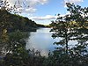 | November 15, 1990 (#90001670) | Off Iowa Highway 1 on the southern bank of the Des Moines River 40°42′31″N 91°58′14″W / 40.708611°N 91.970556°W / 40.708611; -91.970556 (Lacey-Keosauqua State Park, Bathing Area (Area C)) | Keosauqua | |
| 13 | Abner Martin House | 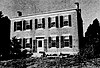 | April 12, 1984 (#84001604) | South of Mount Zion off Iowa Highway 1 40°46′31″N 91°55′37″W / 40.775385°N 91.927082°W / 40.775385; -91.927082 (Abner Martin House) | Mount Zion | |
| 14 | Meek's Flour Mill |  | January 27, 1983 (#83000406) | 1st St. 40°41′52″N 91°48′15″W / 40.697778°N 91.804167°W / 40.697778; -91.804167 (Meek's Flour Mill) | Bonaparte | |
| 15 | Samuel and Mercy Paine House | Upload image | June 29, 2022 (#100007880) | 27421 Cty. Rd. J40 40°43′28″N 91°50′47″W / 40.724471°N 91.846313°W / 40.724471; -91.846313 (Samuel and Mercy Paine House) | Bentonsport vicinity | |
| 16 | Franklin Pearson House |  | May 22, 1978 (#78001267) | Dodge St. 40°44′08″N 91°58′03″W / 40.735556°N 91.9675°W / 40.735556; -91.9675 (Franklin Pearson House) | Keosauqua | |
| 17 | Voltaire Twombley Building |  | July 29, 1993 (#93000655) | 803 1st St. 40°43′52″N 91°57′40″W / 40.731111°N 91.961111°W / 40.731111; -91.961111 (Voltaire Twombley Building) | Keosauqua | |
| 18 | Van Buren County Courthouse |  | November 9, 1977 (#77000562) | 904 4th St. 40°44′00″N 91°57′48″W / 40.733333°N 91.963333°W / 40.733333; -91.963333 (Van Buren County Courthouse) | Keosauqua | |
| 19 | Vernon School | 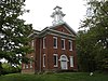 | September 12, 2002 (#02001024) | 26849 South St. 40°43′17″N 91°51′23″W / 40.721389°N 91.856389°W / 40.721389; -91.856389 (Vernon School) | Vernon | |
| 20 | Wickfield Round Barn | Upload image | June 30, 1986 (#86001447) | Off Iowa Highway 2 40°40′04″N 92°01′23″W / 40.667778°N 92.023056°W / 40.667778; -92.023056 (Wickfield Round Barn) | Cantril |
Former listings
Other properties were once listed on the register, but were removed:
| [3] | Name on the Register | Image | Date listed | Date removed | Location | City or town | Description |
|---|---|---|---|---|---|---|---|
| 1 | Goodin Building | Upload image | May 15, 2002 (#02000505) | March 7, 2016 | N. 106 Front St. 40°38′25″N 91°44′38″W / 40.640278°N 91.743889°W / 40.640278; -91.743889 (Goodin Building) | Farmington | |
| 2 | Keosauqua Bridge | Upload image | May 15, 1998 (#98000476) | September 10, 2008 | Iowa Highway 1 over Des Moines River, | Keosauqua | Replaced in 2006. |
| 3 | Midway Stock Farm Barn | Upload image | February 22, 1999 (#99000126) | January 31, 2019 | 0.3 miles south of the junction of Iowa Highways 1 and 16 40°48′09″N 91°55′50″W / 40.8025°N 91.930556°W / 40.8025; -91.930556 (Midway Stock Farm Barn) | Keosauqua | Destroyed by a tornado on July 19, 2018[6].[7] |
See also
Wikimedia Commons has media related to National Register of Historic Places in Van Buren County, Iowa.
- List of National Historic Landmarks in Iowa
- National Register of Historic Places listings in Iowa
- Listings in neighboring counties: Clark (MO), Davis, Henry, Jefferson, Lee, Scotland (MO)
References
- ^ The latitude and longitude information provided in this table was derived originally from the National Register Information System, which has been found to be fairly accurate for about 99% of listings. Some locations in this table may have been corrected to current GPS standards.
- ^ National Park Service, United States Department of the Interior, "National Register of Historic Places: Weekly List Actions", retrieved June 21, 2024.
- ^ a b Numbers represent an alphabetical ordering by significant words. Various colorings, defined here, differentiate National Historic Landmarks and historic districts from other NRHP buildings, structures, sites or objects.
- ^ "National Register Information System". National Register of Historic Places. National Park Service. April 24, 2008.
- ^ The eight-digit number below each date is the number assigned to each location in the National Register Information System database, which can be viewed by clicking the number.
- ^ "57. Midway Stock Farm Barn". Jefferson County, Iowa. Retrieved 2019-03-01.
- ^ Iowa Event Report: EF1 Tornado (Report). National Centers for Environmental Information. 2018. Retrieved March 11, 2019.
{{cite report}}: Unknown parameter|agency=ignored (help)
- v
- t
- e
- List of U.S. National Historic Landmarks by state:
- Alabama
- Alaska
- Arizona
- Arkansas
- California
- Colorado
- Connecticut
- Delaware
- Florida
- Georgia
- Hawaii
- Idaho
- Illinois
- Indiana
- Iowa
- Kansas
- Kentucky
- Louisiana
- Maine
- Maryland
- Massachusetts
- Michigan
- Minnesota
- Mississippi
- Missouri
- Montana
- Nebraska
- Nevada
- New Hampshire
- New Jersey
- New Mexico
- New York
- North Carolina
- North Dakota
- Ohio
- Oklahoma
- Oregon
- Pennsylvania
- Rhode Island
- South Carolina
- South Dakota
- Tennessee
- Texas
- Utah
- Vermont
- Virginia
- Washington
- West Virginia
- Wisconsin
- Wyoming
 National Register of Historic Places portal
 Category


Municipalities and communities of Van Buren County, Iowa, United States | ||
|---|---|---|
County seat: Keosauqua | ||
| Cities |  | |
| CDPs | ||
| Other unincorporated communities | ||
| Ghost town | ||
| ||


