Pandivere Upland
Upland in Estonia
You can help expand this article with text translated from the corresponding article in Estonian. (August 2023) Click [show] for important translation instructions.
- Machine translation, like DeepL or Google Translate, is a useful starting point for translations, but translators must revise errors as necessary and confirm that the translation is accurate, rather than simply copy-pasting machine-translated text into the English Wikipedia.
- Do not translate text that appears unreliable or low-quality. If possible, verify the text with references provided in the foreign-language article.
- You must provide copyright attribution in the edit summary accompanying your translation by providing an interlanguage link to the source of your translation. A model attribution edit summary is
Content in this edit is translated from the existing Estonian Wikipedia article at [[:et:Pandivere kõrgustik]]; see its history for attribution. - You may also add the template
{{Translated|et|Pandivere kõrgustik}}to the talk page. - For more guidance, see Wikipedia:Translation.
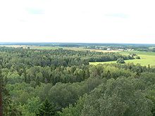
Pandivere Upland (or Pandivere Heights, Estonian: Pandivere kõrgustik) is hilly area of higher elevation in Northern Estonia.[1]
It contains the highest point of Northern Estonia: Emumägi (166 m).[1]
The area is named for the village of Pandivere.[2]
References
- ^ a b "Estonica.org - Pandivere kõrgustik". www.estonica.org. Retrieved 29 March 2020.
- ^ "Pandivere küla" (in Estonian). eestigiid.ee. Retrieved 16 April 2011.
59°14′N 26°17′E / 59.23°N 26.28°E / 59.23; 26.28


