Quiraing
Landform in Scotland

The Quiraing (Scottish Gaelic: Cuith-Raing)[1] is a landform on the eastern face of Meall na Suiramach, the northernmost summit of the Trotternish escarpment on the Isle of Skye, Scotland. It takes the form of a craterous hollow surrounded by a high rampart of rock.[2] Within the hollow is a raised plateau the size of a football field, known as the Table. Other distinctive features of the landscape are the Needle, a jagged pinnacle rising to 120 feet (37 m), and the Prison, a mass of rock resembling a medieval keep.[3][4]
Like the rest of the Trotternish escarpment, the Quiraing was formed when a thick layer of flood basalt spread over the peninsula and destabilized the weak sedimentary rocks below, causing a succession of landslides.[5] It has been renowned for its fantastical appearance since the Victorian period. The poet Alexander Smith dubbed it "a nightmare of nature".[6]
-
 View of the Quiraing (left) and the Prison (right)
 -
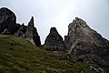
 The Prison
 -
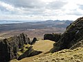
 The entrance to the Quiraing
 -
 The Needle
 -
 The Table


References
- ^ Henderson, George (1910). The Norse Influence on Celtic Scotland. Glasgow: James MacLehose. p. 61.
- ^ Groomes, Francis H. (n.d.). Ordnance Gazetteer of Scotland: A Survey of Scottish Topography, Statistical, Biographical, and Historical. Vol. 5 (2nd ed.). London: William Mackenzie. pp. 231–232.
- ^ Townsend, Chris (2001). Collins Rambler's Guide: Isle of Skye. London: HarperCollins. pp. 55–59. ISBN 978-0-00-220200-8.
- ^ McKelvie, Robin and Jenny (2011). National Geographic Traveler: Scotland. Washington: National Geographic. pp. 234–235. ISBN 978-1-4262-0671-9.
- ^ Ballantyne, Colin K. (2008). "Scottish landform examples – 2: The landslides of Trotternish, Isle of Skye". Scottish Geographical Magazine. 107 (2): 130–135. doi:10.1080/00369229118736821.
- ^ Smith, Alexander (1866). A Summer in Skye. London and New York: Alexander Strahan. p. 232.
External links
 Media related to Quiraing at Wikimedia Commons
- v
- t
- e
Isle of Skye
- Portree
- Broadford
- Dunvegan
- Kyleakin
- Uig (Snizort)
and settlements
- Achachork
- Aird of Sleat
- Ardvasar
- Armadale
- Ashaig
- Bernisdale
- Bornesketaig
- Boreraig
- Borreraig
- Borrodale
- Borve
- Bracadale
- Breakish
- Brogaig
- Bualintur
- Camastianavaig
- Camuscross
- Carbost, Loch Harport
- Carbost, Trotternish
- Claigan
- Colbost
- Drumfearn
- Drynoch
- Dunan
- Duntulm
- Eabost
- Edinbane
- Elgol
- Ellishadder
- Eynort
- Eyre
- Fasach
- Feorlig
- Feriniquarrie
- Ferindonald
- Fiskavaig
- Flashader
- Flodigarry
- Galtrigill
- Garafad
- Geary
- Gedintailor
- Gillen
- Glendale
- Halistra
- Harlosh
- Harrapool
- Heaste
- Heribusta
- Hungladder
- Idrigill
- Isleornsay
- Kensaleyre
- Kilbride
- Kilmaluag
- Kilmarie
- Kilmore
- Kilmuir
- Kilvaxter
- Kingsburgh
- Kylerhea
- Lealt
- Lower Breakish
- Luib
- Milovaig
- Mugeary
- Ollach
- Ose
- Peinachorran
- Peinlich
- Portnalong
- Ramasaig
- Roag
- Sconser
- Skeabost
- Sligachan
- Staffin
- Stein
- Struan
- Suladale
- Talisker
- Tarskavaig
- Teangue
- Torrin
- Totaig
- Tote
- Treaslane
- Trumpan
- Uig (Duirinish)
- Uigshader
- Ullinish
- Upper Breakish
- Vatten
- Am Basteir
- Beinn na Caillich
- Blà Bheinn
- Bruach na Frìthe
- Clach Glas
- Glamaig
- Healabhal Bheag
- Healabhal Mhòr
- Sgùrr a' Ghreadaidh
- Sgùrr a' Mhadaidh
- Sgùrr MhicChoinnich
- Sgùrr na Banachdaich
- Sgùrr nan Gillean
- Sgùrr Dearg
- Sgùrr a' Mhadaidh Ruaidh
- Marsco
- Quiraing/Meall na Suiramach
- Sgùrr Alasdair
- The Storr
- MV Glenachulish
- Skye Bridge
57°38′27″N 6°16′26″W / 57.64083°N 6.27389°W / 57.64083; -6.27389


