Serrato
Municipality in Andalusia, Spain
Flag

Coat of arms
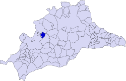
Municipal location in the Province of Málaga
36°53′18″N 4°58′28″W / 36.88833°N 4.97444°W / 36.88833; -4.97444
 Spain
Spain Andalusia
 (2018)
29471
Serrato is a town and municipality in the province of Málaga, part of the autonomous community of Andalusia in southern Spain. It was separated from the municipality of Ronda on 19 December 2014.[1]

References
- ^ "DECRETO 110/1999, de 11 de mayo, por el que se crea la Entidad Local Autónoma de Serrato, en el municipio de Ronda (Málaga)". www.juntadeandalucia.es (in Spanish). Retrieved 26 June 2019.
- v
- t
- e
Municipalities of the province of Málaga
- Alameda
- Alcaucín
- Alfarnate
- Alfarnatejo
- Algarrobo
- Algatocín
- Alhaurín de la Torre
- Alhaurín el Grande
- Almáchar
- Almargen
- Almogía
- Álora
- Alozaina
- Alpandeire
- Antequera
- Árchez
- Archidona
- Ardales
- Arenas
- Arriate
- Atajate
- Benadalid
- Benahavís
- Benalauría
- Benalmádena
- Benamargosa
- Benamocarra
- Benaoján
- Benarrabá
- Campillos
- Canillas de Aceituno
- Canillas de Albaida
- Cañete la Real
- Carratraca
- Cartajima
- Cártama
- Casabermeja
- Casarabonela
- Casares
- Coín
- Colmenar
- Comares
- Cómpeta
- Cortes de la Frontera
- Cuevas Bajas
- Cuevas de San Marcos
- Cuevas del Becerro
- Cútar
- El Borge
- El Burgo
- Estepona
- Faraján
- Frigiliana
- Fuengirola
- Fuente de Piedra
- Gaucín
- Genalguacil
- Guaro
- Humilladero
- Igualeja
- Istán
- Iznate
- Jimera de Líbar
- Jubrique
- Júzcar
- Macharaviaya
- Málaga
- Manilva
- Marbella
- Mijas
- Moclinejo
- Mollina
- Monda
- Montejaque
- Nerja
- Ojén
- Parauta
- Periana
- Pizarra
- Pujerra
- Rincón de la Victoria
- Riogordo
- Ronda
- Salares
- Sayalonga
- Sedella
- Sierra de Yeguas
- Teba
- Tolox
- Torremolinos
- Torrox
- Totalán
- Valle de Abdalajís
- Vélez-Málaga
- Villanueva de Algaidas
- Villanueva de la Concepción
- Villanueva de Tapia
- Villanueva del Rosario
- Villanueva del Trabuco
- Viñuela
- Yunquera

| Authority control databases |
|
|---|
 | This article about a location in Andalusia, Spain, is a stub. You can help Wikipedia by expanding it. |
- v
- t
- e


