Skarpnäck metro station
Stockholm Metro station
59°15′59″N 18°7′57″E / 59.26639°N 18.13250°E / 59.26639; 18.13250| Preceding station |  Stockholm metro Stockholm metro | Following station | ||
|---|---|---|---|---|
| Bagarmossen towards Åkeshov | Line 17 | Terminus | ||
Location | |
|---|---|
 |
Skarpnäck is a Stockholm metro station located in the Skarpnäcksfältet subdistrict of Skarpnäcks Gård district, Skarpnäck borough.
The station is the southern terminus for the green line 17 and the easternmost Stockholm metro station (as of 2024). The station is 25 metres (82 ft) below ground and was opened on 15 August 1994 as a one-station extension from Bagarmossen, making it the hundredth station in the Stockholm metro. As of August 2024 it is still the newest station in the system.[3] The underground Bagarmossen metro station was opened at the same time, but replaced an older station in Bagarmossen, which was closed on 8 July 1994.
Skarpnäck is an underground station with a single vault spanning across the island platform and tracks; its span of 22 metres (72 ft) is the largest in the Stockholm metro. The station artwork by American sculptor Richard Nonas consists of seventeen granite "benches" placed along the platform, as well as a red clinker floor and red-painted shotcrete walls alluding to the red brick buildings in Skarpnäck.[4]
-
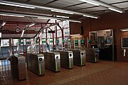 Ticket barriers and escalator access to the underground platform
 -
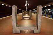 Granite bench


References
- ^ a b c d Alfredsson, Björn; Berndt, Roland; Harlén, Hans (2007). Stockholm under: 100 stationer (in Swedish) (2nd ed.). Stockholm: Bromberg. p. 44. ISBN 978-91-7337-051-6. SELIBR 10614768.
- ^ "Fakta om SL och regionen 2019" (PDF) (in Swedish). Storstockholms Lokaltrafik. p. 51. Archived (PDF) from the original on 27 December 2020. Retrieved 1 April 2021.
- ^ Schwandl, Robert. "Stockholm". urbanrail.
- ^ Söderström, Göran, ed. (2000). En värld under jord: färg och form i tunnelbanan (in Swedish) (2nd ed.). Stockholm: Stockholmia. pp. 58, 238. ISBN 91-7031-107-2. SELIBR 7593308.
External links
- Images of Skarpnäck
- v
- t
- e
Green line of the  Stockholm metro
 Stockholm metro
| Shared stations | |
|---|---|
| 17 |
|
| 18 |
|
| 19 |


 | This article about a Swedish railway station is a stub. You can help Wikipedia by expanding it. |
- v
- t
- e
 | This Stockholm Metro article is a stub. You can help Wikipedia by expanding it. |
- v
- t
- e


