South Baldy (New Mexico)


South Baldy
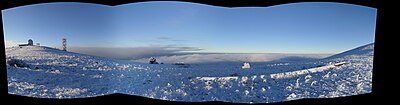
South Baldy is the highest point of the Magdalena Mountains in central New Mexico, in the United States. It is in the Magdalena Ranger District of the Cibola National Forest, about 9 mi (15 km) south of Magdalena and 18 mi (30 km) west-southwest of Socorro. It lies just north of the Langmuir Laboratory for Atmospheric Research of the New Mexico Institute of Mining and Technology, and site of the Magdalena Ridge Observatory Interferometer.
South Baldy can be accessed easily from the dirt road leading to Langmuir. Alternately, it can be accessed by trail from below. From a campground in Water Canyon (accessed from the northeast side of the range), a trail follows Forest Road 406 and then Trail 10 up Copper Canyon to the main crest of the range, where it joins Trail 8, the North Baldy Trail, which follows the crest. A short hike south on this trail and a little off-trail ascent leads to the summit of South Baldy.[3]
The peak is the site of an annual mountain bike ascent race up the Langmuir Road as part of the Tour of Socorro.
While not of exceptional height for New Mexico mountains, South Baldy is surrounded by low terrain, and hence is a highly visible landmark and the sixth most topographically prominent peak in the state.[4]

References
- ^ a b "Magdalena Peak 2". NGS Data Sheet. National Geodetic Survey, National Oceanic and Atmospheric Administration, United States Department of Commerce. Retrieved 2013-01-27.
- ^ "South Baldy, New Mexico". Peakbagger.com. Retrieved 2013-01-27.
- ^ "South Baldy Peak". SummitPost.org.
- ^ "New Mexico Peaks with 2000 feet of Prominence". Peakbagger.com. Retrieved 2013-01-27.
External links
- "South Baldy". Geographic Names Information System. United States Geological Survey, United States Department of the Interior. Retrieved 2013-01-27.
- v
- t
- e
- Black Mountain (Catron County)
- McKnight Mountain
- Cerro Grande
- Chicoma Mountain
- Redondo Peak
- South Baldy
- Pyramid Peak
(Cibola County)
- Mount Taylor
- West Blue Mountain
| Manzano Mountains | |
|---|---|
| Sandia Mountains |
| Cimarron Range |
|
|---|---|
| Taos Mountains |
|
| Others |
|
- Haystack Mountain
- Mount Sedgwick
- Aden Crater
- Alamo Hueco Mountains
- Animas Mountains
- Brazos Mountains
- Caballo Mountains
- Canjilón Mountain
- Canyon Creek Mountains
- Capitan Mountains
- Capulin Peak
- Cedar Mountain Range
- Datil Mountains
- Dirty Point
- Doña Ana Mountains
- Eagle Peak
- East Potrillo Mountains
- Elephant Butte (Hidalgo County)
- Elephant Butte (Sierra County)
- Fajada Butte
- Florida Mountains
- Franklin Mountains
- Granite Peak
- Guadalupe Mountains
- Guadalupe Mountains (Hidalgo County)
- Hosta Butte
- Hueco Mountains
- Huérfano Mountain
- Jicarilla Mountains
- Jornada del Muerto Volcano
- Ladron Peak
- Little Burro Mountains
- Little Hatchet Mountains
- Little San Pascual Mountain
- Luera Mountains
- Sierra Nacimiento
- Ocate Peak
- Ortiz Mountains
- Picacho Mountain
- Robledo Mountains
- San Antonio Mountain
- San Mateo Mountains (Socorro County)
- Sierra Aguilada
- Sierra Blanca
- Sierra de las Uvas
- West Potrillo Mountains
| Authority control databases: National |
|
|---|
 | This New Mexico state location article is a stub. You can help Wikipedia by expanding it. |
- v
- t
- e


