Spread Eagle Peak
Mountain in the state of Colorado


Spread Eagle Peak
Location in Colorado
Show map of Colorado
Spread Eagle Peak
Spread Eagle Peak (the United States)
Show map of the United StatesSangre de Cristo Range[2]
Spread Eagle Peak is a 13,423-foot (4,091 m) mountain summit in Custer County, Colorado, United States.
Description
Spread Eagle Peak is set in the Sangre de Cristo Range which is a subrange of the Rocky Mountains. It is the 15-highest summit in Custer County,[4] and can be seen from Highway 69 and Highway 96 near the town of Westcliffe. The mountain is located in the Sangre de Cristo Wilderness on land managed by San Isabel National Forest.[2] Precipitation runoff from the mountain's slopes drains into tributaries of Grape Creek which in turn is a tributary of the Arkansas River. Topographic relief is significant as the summit rises 1,940 feet (591 m) above Lake of the Clouds in 0.6 mile (1 km) and 3,000 feet (914 m) above North Taylor Creek in one mile (1.6 km). The mountain's toponym has been officially adopted by the United States Board on Geographic Names.[5]
Climate
According to the Köppen climate classification system, Spread Eagle Peak is located in an alpine subarctic climate zone with cold, snowy winters, and cool to warm summers.[6] Due to its altitude, it receives precipitation all year, as snow in winter, and as thunderstorms in summer, with a dry period in late spring.
Gallery
-
 Rito Alto Peak (left) and Spread Eagle Peak (right)
 -
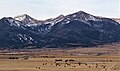
 Sangre de Cristos with Spread Eagle Peak furthest to right
 -
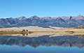 Spread Eagle Peak (left of center) viewed from DeWeese Reservoir
 -
 Spread Eagle Peak framed to right under "Ranch"


See also
- Sangre de Cristo Mountains
- Wet Mountain Valley
 Mountains portal
- Thirteener

References
- ^ Robert M. Ormes (2000), Guide to the Colorado Mountains, Colorado Mountain Club Press, ISBN 9780967146607, p. 103.
- ^ a b c "Spread Eagle Peak, Colorado". Peakbagger.com. Retrieved May 4, 2023.
- ^ a b c "Spread Eagle Peak – 13,436' CO". listsofjohn.com. Retrieved May 4, 2023.
- ^ a b "Spread Eagle Peak, Peakvisor.com". Retrieved May 3, 2023.
- ^ a b "Spread Eagle Peak". Geographic Names Information System. United States Geological Survey, United States Department of the Interior. Retrieved May 4, 2023.
- ^ Peel, M. C.; Finlayson, B. L.; McMahon, T. A. (2007). "Updated world map of the Köppen−Geiger climate classification". Hydrol. Earth Syst. Sci. 11. ISSN 1027-5606.
External links
- Spread Eagle Peak: weather forecast
- v
- t
- e
Places adjacent to Spread Eagle Peak
| Mount Marcy | San Isabel National Forest | Swift Creek |
 | ||
| San Luis Valley |  Spread Eagle Peak Spread Eagle Peak | Westcliffe |
 | ||
| Rito Alto Peak | North Taylor Creek | Grape Creek |


