Squaretop Mountain
Mountain in the American state of Wyoming


Squaretop Mountain
Location in Wyoming
Show map of Wyoming
Squaretop Mountain
Squaretop Mountain (the United States)
Show map of the United StatesSquaretop Mountain is an 11,695-foot-elevation (3,565-meter) mountain summit located in Sublette County of Wyoming, United States.[3]
Geography
The peak is the emblematic geographical feature of the remote Wind River Range and is set seven miles west of the Continental Divide.[5] It is situated in the Bridger Wilderness on land managed by Bridger-Teton National Forest. Topographic relief is significant as the northeast aspect rises 3,700 feet (1,100 meters) above the Green River in one-half mile. The iconic view of Squaretop and Green River Lakes has been on the Wyoming license plate since 2016.
Climate
According to the Köppen climate classification system, Squaretop Mountain is located in an alpine subarctic climate zone with long, cold, snowy winters, and cool to warm summers.[6] Due to its altitude, it receives precipitation all year, as snow in winter, and as thunderstorms in summer. Precipitation runoff from the mountain drains north into the Green River.
Climbing
The first ascent of Squaretop was made sometime before 1921 by William John Stroud (1854–1946), via the class 2 southeast ledges. Fred Beckey and Layton Kor climbed the Northeast Face in 1960.[7]
Other established climbing routes on Squaretop's walls:[8]
- West Gully – 1937 – class 3 – H. H. Bliss
- East Face Center – 1958 – (IV 5th) – Bill Byrd, Dave Dingman, Roland Wyatt
- North Buttress – 1960 – (III 5.7) – Ed Cooper, Ron Niccoli
- East Face Right – 1965 – (V 5.8) – Fred Beckey, Jerry Fuller
- Southeast Face – 1971 – (II 5.6) – Vince Lee, E. Park, M. Stephens, C. Zukowski
- West Couloir – 1972 – (II 5.5) – Vince Lee, Bo Beckham, Greg Smith
- West Face Dihedral – 1974 – (V 5.10) – Greg Lowe, Jeff Lowe, Kent Christensen
- East Face Left – 1984 – (V 5.10d) – Jeff Lowe, Renato Casarotto
- West Face Right – 1992 – (IV 5.9 A2) – Scott Cole, John Malken
- AC/DC – 1998 – (IV 5.10) – Andy Carson, Dan Carson
- Miscreant Line and Conveyor Belt (East Face) – 2001 – (V 5.10d) – Tod Anderson, Skyler Crane, James Donnell, Ernest Moskovics
- Marginally Orange – 2009 – (IV 5.10) Norm Goltra, Steve Walker
Hazards
Encountering bears is a concern in the Wind River Range.[9] There are other concerns as well, including bugs, wildfires, adverse snow conditions and nighttime cold temperatures.[10]
Importantly, there have been notable incidents, including accidental deaths, due to falls from steep cliffs (a misstep could be fatal in this class 4/5 terrain) and due to falling rocks, over the years, including 1993,[11] 2007 (involving an experienced NOLS leader),[12] 2015[13] and 2018.[14] Other incidents include a seriously injured backpacker being airlifted near SquareTop Mountain[15] in 2005,[16] and a fatal hiker incident (from an apparent accidental fall) in 2006 that involved state search and rescue.[17] The U.S. Forest Service does not offer updated aggregated records on the official number of fatalities in the Wind River Range.
Gallery
-
-
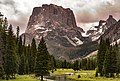
 from Green River Lakes
 -

-
 from Green River Lakes with White Rock on left, "Tabletop" on right
 -
 from Green River Lakes
 -
 from Green River Lakes
 -
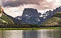
 2020 Wyoming license plate featuring Squaretop Mountain with Green River Lakes
 -
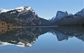 White Rock (left), Squaretop Mountain (right) reflected in Green River Lakes.
White Rock is a dolomite and limestone cliff that rises 3,300 feet above the lake.


See also
References
- ^ a b c "Squaretop Mountain, Wyoming". Peakbagger.com. Retrieved 2021-07-26.
- ^ a b c "Squaretop Mountain - 11,695' WY". listsofjohn.com. Retrieved 2021-07-26.
- ^ a b "Squaretop Mountain". Geographic Names Information System. United States Geological Survey, United States Department of the Interior. Retrieved July 26, 2021.
- ^ Joe Kelsey, 2013, Climbing and Hiking in the Wind River Mountains, Falcon Guides, ISBN 9781493001354, page 33.
- ^ Joe Kelsey, 2013, Climbing and Hiking in the Wind River Mountains, Falcon Guides, ISBN 9781493001354, page 37.
- ^ Peel, M. C.; Finlayson, B. L.; McMahon, T. A. (2007). "Updated world map of the Köppen−Geiger climate classification". Hydrol. Earth Syst. Sci. 11. ISSN 1027-5606.
- ^ Fred Beckey, 1961, North America, United States, Wyoming—Wind River Range, Northeast Face, Squaretop Americanalpineclub.org
- ^ Joe Kelsey, 2013, Climbing and Hiking in the Wind River Mountains, Falcon Guides, ISBN 9781493001354, pages 110–115, 419.
- ^ Staff (April 24, 2017). "Bear Safety in Wyoming's Wind River Country". WindRiver.org. Archived from the original on July 26, 2021. Retrieved May 31, 2022.
- ^ Ballou, Dawn (July 27, 2005). "Wind River Range condition update - Fires, trails, bears, Continental Divide". PineDaleOnline News. Archived from the original on April 21, 2021. Retrieved May 31, 2022.
- ^ Staff (1993). "Falling Rock, Loose Rock, Failure to Test Holds, Wyoming, Wind River Range, Seneca Lake". American Alpine Club. Archived from the original on July 26, 2021. Retrieved May 31, 2022.
- ^ MacDonald, Dougald (August 14, 2007). "Trundled Rock Kills NOLS Leader". Climbing. Archived from the original on July 26, 2021. Retrieved May 31, 2022.
- ^ Staff (December 9, 2015). "Officials rule Wind River Range climbing deaths accidental". Casper Star-Tribune. Archived from the original on July 26, 2021. Retrieved May 31, 2022.
- ^ Dayton, Kelsey (August 24, 2018). "Deadly underestimation". WyoFile News. Archived from the original on July 26, 2021. Retrieved May 31, 2022.
- ^ Funk, Jason (2009). "Squaretop Mountain Rock Climbing". Mountain Project. Archived from the original on July 26, 2021. Retrieved May 31, 2022.
- ^ Staff (July 22, 2005). "Injured man rescued from Square Top Mtn - Tip-Top Search & Rescue helps 2 injured on the mountain". PineDaleOnline News. Archived from the original on July 26, 2021. Retrieved May 31, 2022.
- ^ Staff (September 1, 2006). "Incident Reports - September, 2006 - Wind River Search". WildernessDoc.com. Archived from the original on January 27, 2020. Retrieved May 31, 2022.
External links
- Squaretop Mountain rock climbing: Mountainproject.com
- Weather forecast: Squaretop Mountain
- v
- t
- e
- Abiathar Peak
- Atkins Peak
- Barronette Peak
- Breccia Peak
- Clayton Mountain
- Colter Peak
- Druid Peak
- Eagle Peak
- Fortress Mountain
- Francs Peak
- Index Peak
- Mount Chittenden
- First Peoples Mountain
- Mount Hornaday
- Mount Langford
- Mount Norris
- Mount Schurz
- Mount Stevenson
- Pilot Peak
- Sheep Mesa
- The Thunderer
- Washakie Needles
- Younts Peak
| Bear Lodge Mountains | |
|---|---|
| Others |
- Antler Peak
- Bannock Peak
- Bunsen Peak
- Clagett Butte
- Dome Mountain (Park County)
- Echo Peak
- Gray Peak
- Joseph Peak
- Mount Everts
- Mount Haynes
- Mount Holmes
- Mount Jackson
- Purple Mountain
- Quadrant Mountain
- Sepulcher Mountain
- Terrace Mountain
- Three Rivers Peak
- Trilobite Point
- White Peaks
- Darwin Peak
- Doubletop Peak
- Sheep Mountain
- Elk Mountain (Carbon County)
- Medicine Bow Peak
- Albright Peak
- Battleship Mountain
- Bivouac Peak
- Buck Mountain
- Cathedral Group
- Cleaver Peak
- Cloudveil Dome
- Disappointment Peak
- Doane Peak
- Dry Ridge Mountain
- Eagles Rest Peak
- Elk Mountain (Teton County)
- Forellen Peak
- Fossil Mountain
- Grand Teton
- Green Lakes Mountain
- Housetop Mountain
- The Jaw
- Littles Peak
- Maidenform Peak
- Middle Teton
- Moose Mountain
- Mount Bannon
- Mount Glory
- Mount Hunt
- Mount Jedediah Smith
- Mount Meek
- Mount Moran
- Mount Owen
- Mount Saint John
- Mount Wister
- Mount Woodring
- Mount Woodrow Wilson
- Nez Perce Peak
- Owl Peak
- Prospectors Mountain
- Rammell Mountain
- Ranger Peak
- Raynolds Peak
- Red Mountain
- Rendezvous Mountain
- Rendezvous Peak
- Rock of Ages
- Rockchuck Peak
- Rolling Thunder Mountain
- Shadow Peak
- South Teton
- Spearhead Peak
- Static Peak
- Survey Peak
- Symmetry Spire
- Table Mountain
- Teepe Pillar
- Teewinot Mountain
- Temple Peak
- Thor Peak
- Traverse Peak
- Veiled Peak
- The Wall
- Window Peak
- American Legion Peak
- Atlantic Peak
- Bair Peak
- Bastion Peak
- Bastion Peak-Northeast Peak
- Bears Ears Mountain
- Big Sandy Mountain
- Block Tower
- Bow Mountain
- Brown Cliffs North
- Cathedral Peak
- Desolation Peak
- Dog Tooth Peak
- Dome Mountain (Hot Springs County)
- Doublet Peak
- Downs Mountain
- East Temple Peak
- Flagstone Peak (Fremont County)
- Fremont Peak
- Gannett Peak
- Harrower Peak
- Henderson Peak
- Jackson Peak
- Klondike Peak
- Knife Point Mountain
- Lander Peak
- Lizard Head Peak
- Mitchell Peak
- Mount Bonneville
- Mount Chauvenet
- Mount Febbas
- Mount Helen
- Mount Hooker
- Mount Koven
- Mount Lander
- Mount Nystrom
- Mount Owen
- Mount Sacagawea
- Mount Warren
- Mount Washakie
- Mount Whitecap
- Overhanging Tower
- Payson Peak
- Pingora Peak
- Pylon Peak
- Raid Peak
- Rampart Peak
- Roaring Fork Mountain
- Roberts Mountain
- Shale Mountain
- Sharks Nose
- South Downs Mountain
- The Sphinx
- Split Mountain
- Sunbeam Peak
- Three Waters Mountain
- Torrey Peak
- Turret Peak
- Twin Peaks
- Union Peak
- Valentine Mountain
- Valentine Peak
- War Bonnet Peak
- Warrior Peaks
- Watch Tower
- Whiskey Mountain
- Wind River Peak
- Wolfs Head
- Amethyst Mountain
- Aspen Mountain
- Barlow Peak
- Bridger Mountains
- Cook Peak
- Copper Mountain
- Dirty Mountain
- Douglas Knob
- Dunraven Peak
- Factory Hill
- Ferris Mountains
- Folsom Peak
- Garfield Peak
- Granite Mountains
- Granite Peak
- Heart Mountain
- Hedges Peak
- Hoyt Peak
- Jelm Mountain
- Mansface Hill
- Mount Hancock
- Mount Leidy
- Mount Sheridan
- Mount Washburn
- National Park Mountain
- Owl Creek Mountains
- Prospect Peak (Park County)
- Rawhide Buttes
- Roaring Mountain
- Sierra Madre Range
- Signal Mountain
- Snake River Range
- Specimen Ridge
- Sublette Mountain
- Tongue Butte
- Trischman Knob
- White Mountain
- Wilkins Peak
Portals:
 Geography
 Geology
 Mountains


