Strijbeek
Village in North Brabant, Netherlands

Flag

Coat of arms
51°30′05″N 4°47′49″E / 51.50139°N 4.79694°E / 51.50139; 4.79694
[1]
[2]
(2023[1])[1]
4856
Strijbeek is a village in the Dutch province of North Brabant. It is located in the municipality of Alphen-Chaam 11 km south of the city of Breda.[3]
History
The name Strijbeek could come from Strijdbeek, or a brook that was fought over. Curiously, the brook, to which Strijbeek owes its name, is today known as Strijbeekse Beek.
The area around Strijbeek has long been inhabited. In 1937, an urn field was found from the Marne culture, dating to the 5th century B.C. Present-day Strijbeek probably originated in the 13th century as a stream valley settlement. Here the Oude Bredase Baan joined the connecting road between Hoogstraten and Breda. Despite this favourable location, the village never really developed.[citation needed]
Gallery
-
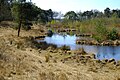 Strijbeek Heath

References
- ^ a b c "Kerncijfers wijken en buurten 2023". Statistics Netherlands. 15 March 2024. Retrieved 29 July 2024.
- ^ "Postcodetool for 4855AA". Actueel Hoogtebestand Nederland (in Dutch). Het Waterschapshuis. Retrieved 14 April 2022.
- ^ ANWB Topografische Atlas Nederland, Topografische Dienst and ANWB, 2005.
External links
![]() Media related to Strijbeek at Wikimedia Commons
Media related to Strijbeek at Wikimedia Commons
| Authority control databases: National |
|
|---|
 | This North Brabant location article is a stub. You can help Wikipedia by expanding it. |
- v
- t
- e


