Tanambao Marivorahona
Place in Diana, Madagascar
Tanambao Marivorahona Marivorahona | |
|---|---|
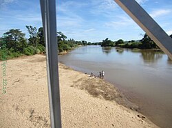 Manajeba River at Marivorahona | |
| 13°5′S 49°5′E / 13.083°S 49.083°E / -13.083; 49.083 | |
| Country |  Madagascar Madagascar |
| Region | Diana |
| District | Ambilobe |
| Government | |
| • Mayor | Justin Bemiarina |
| Elevation [1] | 24 m (79 ft) |
| Population (2018)[2] | |
| • Total | 15,654 |
| Time zone | UTC3 (EAT) |
| Postal code | 204 |
Marivorahona or Tanambao Marivorahona is a municipality (French: commune, Malagasy: kaominina) in northern Madagascar. It belongs to the district of Ambilobe, which is a part of Diana Region.
According to 2018 census the population of Tanambao Marivorahona was 15,654.
Only primary schooling is available in town. The majority (94%) of the population are farmers. The most important crops are sugarcane and tomato, while other important agricultural products are cotton, sweet potato and rice. Industry and services both provide employment for 3% of the population.[3]
Geographie
Tanambao Marivorahona lies 13 km from Ambilobe and 123 km from Antsiranana (Diego Suarez) on the RN 6[4] in the fertile plains of the Manajeba River. It covers also the villages (fokontany) of Ananjaka, Antsatrambalo, Ambodiampana, Mahamasina, Bobasatrana, Isesy, Mahavelona, Marivorahona, Tanambao Marivorahona and Betsimiranjana.[5]
The entrance of the Ankarana Reserve is in Mahamasina.
References
- ^ Estimated based on DEM data from Shuttle Radar Topography Mission
- ^ Census 2018
- ^ "ILO census data". Cornell University. 2002. Retrieved 2008-02-13.
- ^ L'Express Madagascar
- ^ www.mef.gov.mg - DECRET n°2015–592 portant classement des Communes en Communes urbaines ou en Communes rurales.
- v
- t
- e

- Ambalahonko
- Ambanja
- Ambaliha
- Ambodimanga
- Ambohimarina
- Ambohimena
- Ambohitrandriana
- Ankatafa
- Ankingameloko
- Anorotsangana
- Antafiambotry
- Antranokarany
- Antsakoamanondro
- Antsahabe (Ambanja)
- Antsatsaka
- Antsirabe
- Bemanevika Haut Sambirano
- Bemaneviky Ouest
- Benavony
- Djangoa
- Maevatanana, Diana
- Maherivaratra
- Marotolana
- Marovato

- Ambolobozobe
- Ambondrona
- Andrafiabe
- Andranofanjava
- Andranovondronina
- Anivorano Nord
- Ankarangona
- Anketrakabe
- Anivorano Nord
- Antanamitarana
- Antsahampano
- Antsalaka
- Antsiranana II
- Antsoha
- Bobakilandy
- Bobasakoa
- Joffreville
- Mahalina
- Mahavanona
- Mangaoka
- Mosorolava
- Ramena
- Sadjoavato
- Sakaramy
- Nosy Be
- Ambatozavavy
- Ampangorina
- Befotaka, Nosy Be
- Dzamandzar
5 districts; 51 communes
13°5′S 49°5′E / 13.083°S 49.083°E / -13.083; 49.083
 | This Diana Region of Madagascar location article is a stub. You can help Wikipedia by expanding it. |
- v
- t
- e


