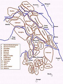
46°46′N26°16′E / 46.767°N 26.267°E / 46.767; 26.267Map of the Eastern Carpathians, with the Tarcău Mountains in the center
The Tarcău Mountains (Romanian: Munții Tarcău, Hungarian: Tarkő-hegység) are a mountain range, part of the Moldavian-Muntenian Carpathians of the Outer Eastern Carpathians.
The range is located between the latitudes 46°25′ and 46°57′ N and between the longitudes 25°52′ and 26°28′ E. The range is bordered by the following rivers:
The Bicaz and the Bistrița to the north.
The Dămuc and Valea Rece to the west.
The Trotuș to the south.
To the east they are limited by the subcarpathian hills along a line running approximately from Piatra Neamț to Moinești. The highest point is Grindușu Peak at 1,664 metres (5,459 feet).
References
"Munții Tarcău – Descriere". bocutz.iscaria.ro (in Romanian). Archived from the original on 2010-08-20.
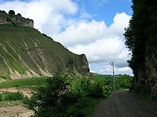
The Tarcău Mountains, with the Bistrița River valley and the Bâtca Doamnei LakeCascade in Tarcău communeFalcon Stone (Piatra Șoimului) in Piatra Șoimului commune