Totes Gebirge
Mountain range in Austria
You can help expand this article with text translated from the corresponding article in German. (November 2016) Click [show] for important translation instructions.
- View a machine-translated version of the German article.
- Machine translation, like DeepL or Google Translate, is a useful starting point for translations, but translators must revise errors as necessary and confirm that the translation is accurate, rather than simply copy-pasting machine-translated text into the English Wikipedia.
- Do not translate text that appears unreliable or low-quality. If possible, verify the text with references provided in the foreign-language article.
- You must provide copyright attribution in the edit summary accompanying your translation by providing an interlanguage link to the source of your translation. A model attribution edit summary is
Content in this edit is translated from the existing German Wikipedia article at [[:de:Totes Gebirge]]; see its history for attribution. - You may also add the template
{{Translated|de|Totes Gebirge}}to the talk page. - For more guidance, see Wikipedia:Translation.

Totes Gebirge (in red) within the Alps.
The borders of the range according to
Alpine Club classification of the Eastern Alps
The borders of the range according to
Alpine Club classification of the Eastern Alps
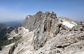
The Totes Gebirge, also known in English as the Dead Mountains, is a mountain range in Austria that forms part of the Northern Limestone Alps, lying between the Salzkammergut and the Ennstaler Alpen. The name Totes Gebirge is derived from the German words tot meaning "dead", referring to the apparent lack of vegetation, and Gebirge meaning "mountain range". The area is a large karst plateau with steep sides, and several mountain peaks above 2000 m. The highest point is the summit of Großer Priel, at 2,515 metres (8,251 ft).

See also
- Limestone Alps
References
- v
- t
- e
Mountain ranges of the Northern Limestone Alps
- Allgäu Alps
- Ammergau Alps
- Bavarian Prealps
- Berchtesgaden Alps
- Brandenberg Alps
- Bregenz Forest
- Chiemgau Alps
- Dachstein
- Ennstal Alps
- Gutenstein Alps
- Hochschwab
- Kaiser
- Karwendel
- Lechquellen
- Lechtal Alps
- Leogang
- Lofer
- Mieming Range
- Mürzsteg Alps
- Upper Austrian Prealps
- Rax-Schneeberg Group
- Salzburg Slate Alps
- Salzkammergut
- Tennen
- Totes Gebirge
- Türnitz Alps
- Wetterstein
- Vienna Woods
- Ybbstal Alps
Authority control databases | |
|---|---|
| International |
|
| National |
|
 | This Styria location article is a stub. You can help Wikipedia by expanding it. |
- v
- t
- e
 | This Upper Austria location article is a stub. You can help Wikipedia by expanding it. |
- v
- t
- e


