Trenno
Quartiere of Milan in Lombardy, Italy
Trenno | |
|---|---|
Quartiere of Milan | |
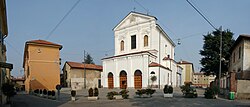 Saint John's Church | |
| Country |  Italy Italy |
| Region | Lombardy |
| Province | Milan |
| Comune | Milan |
| Zone | 8 |
| Time zone | UTC+1 (CET) |
| • Summer (DST) | UTC+2 (CEST) |
Trenno is a district ("quartiere") of Milan, Italy, part of the Zone 8 administrative division of the city. It borders on green areas to the north and west (on the Boscoincittà city park) and to the south (on the Parco di Trenno); to the east, it is adjacent to the Gallaratese district. Before being annexed to Milan, in 1923, it was an autonomous comune.
The district is mostly residential, with low- and medium-income apartment blocks dominating its skyline, although the centre has maintained much of the flavour of a country town (as well as a cascina, "Cascina Campi"); it also has large green areas, the most important of which is the eponymous Parco di Trenno. The district is quite isolated from Milan, being connected to the centre by a single bus line and a few thoroughfare, some of which were still country roads until the late 1990s. The closest stop of the Milan Metro subway is in Bonola, about 1 km from Trenno.
History
The settlement of Trenno exists at least since the Middle Ages as a rural borgo close to the Olona river. In the 19th century the settlement consisted on several cascine (farmhouses), some of which would later spawn independent settlements such as Quarto Cagnino, Quinto Romano and Figino, which would be annexed back to Trenno in 1869. All of these are now districts of Milan.
External links
![]() Media related to Trenno at Wikimedia Commons
Media related to Trenno at Wikimedia Commons
- v
- t
- e

- Brera
- Centro Storico
- Conca del Naviglio
- Guastalla
- Porta Sempione
- Porta Tenaglia
- Adriano
- Crescenzago
- Gorla
- Greco
- Loreto
- Maggiolina
- Mandello
- Mirabello
- Ponte Seveso
- Porta Nuova
- Precotto
- Stazione Centrale
- Turro
- Villaggio dei Giornalisti
- Casoretto
- Cimiano
- Città Studi
- Dosso
- Lambrate
- Ortica
- Porta Monforte
- Porta Venezia
- Quartiere Feltre
- Rottole
- Acquabella
- Calvairate
- Castagnedo
- Cavriano
- Forlanini
- Gamboloita
- La Trecca
- Monluè
- Morsenchio
- Nosedo
- Omero
- Ponte Lambro
- Porta Vittoria
- Porta Romana
- Rogoredo
- San Luigi
- Santa Giulia
- Taliedo
- Triulzo Superiore
- Basmetto
- Cantalupa
- Case Nuove
- Chiaravalle
- Chiesa Rossa
- Conca Fallata
- Fatima
- Gratosoglio
- Le Terrazze
- Macconago
- Missaglia
- Morivione
- Porta Lodovica
- Porta Vigentina
- Quintosole
- Ronchetto delle Rane
- San Gottardo
- Selvanesco
- Stadera
- Torretta
- Vaiano Valle
- Vigentino
- Arzaga
- Barona
- Boffalora
- Cascina Bianca
- Conchetta
- Creta
- Foppette
- Giambellino-Lorenteggio
- Lodovico il Moro
- Moncucco
- Porta Genova
- Porta Ticinese
- Ronchetto sul Naviglio
- San Cristoforo
- Sant'Ambrogio
- Teramo
- Villa Magentino
- Villaggio dei Fiori
- Assiano
- Baggio
- Figino
- Fopponino
- Forze Armate
- Harar
- La Maddalena
- Muggiano
- Porta Magenta
- Quartiere degli Olmi
- Quarto Cagnino
- Quinto Romano
- San Siro
- Valsesia
- Vercellese
- Boldinasco
- Bullona
- Cagnola
- Campo dei Fiori
- Cascina Triulza
- Comina
- Fiera
- Gallaratese
- Garegnano
- Ghisolfa
- Lampugnano
- Musocco
- Porta Volta
- Portello
- Quarto Oggiaro
- QT8
- Roserio
- San Leonardo
- Trenno
- Varesina
- Vialba
- Villapizzone
- Affori
- Bicocca
- Bovisa
- Bovisasca
- Bruzzano
- Ca' Granda
- Centro Direzionale
- Comasina
- Dergano
- Fulvio Testi
- Isola
- La Fontana
- Montalbino
- Niguarda
- Porta Garibaldi
- Porta Nuova
- Prato Centenaro
- Segnano
45°29′28″N 9°06′01″E / 45.49111°N 9.10028°E / 45.49111; 9.10028
 | This article on a location in the Province of Milan is a stub. You can help Wikipedia by expanding it. |
- v
- t
- e


