Wick Mountains
Mountain range in New Zealand
44°47′40″S 167°53′46″E / 44.79431°S 167.89604°E / -44.79431; 167.89604
The Wick Mountains are a range within New Zealand's Fiordland National Park, the country's biggest national park. Their highest peak is Mount Elliot 1,990 metres (6,530 ft),[1] and this can be seen in fine weather from the Milford Track, a popular tourist walking track.
Geography
The range is bounded by the Arthur River to the west, Milford Sound (Piopiotahi) and the valley of the Cleddau River to the west, the Homer Saddle, which separates them from the Darren Mountains to the north west and the valleys of the Neil Burn and Clinton River to the south. The Homer Tunnel lies under the north eastern extreme of the range.[2]
Sheerdown Peak in the range is at the southern end of Milford Sound rising above the airport flat.[2]
The mountains were named by Donald Sutherland after his birthplace in Caithness, Scotland.[3]
| Peak | Height[1] | Coordinate[1] | Picture |
|---|---|---|---|
| Mount Elliot | 1,990 metres (6,530 ft) | 44°46′47″S 167°47′06″E / 44.77979°S 167.78501°E / -44.77979; 167.78501 |  |
| Mount Moir | 1,965 metres (6,447 ft) | 44°46′22″S 167°58′38″E / 44.77267°S 167.97718°E / -44.77267; 167.97718 | |
| Mount Anau | 1,956 metres (6,417 ft) | 44°51′57″S 167°55′18″E / 44.86588°S 167.92170°E / -44.86588; 167.92170 | |
| Mount Mitchelson | 1,936 metres (6,352 ft) | 44°48′04″S 167°53′27″E / 44.80120°S 167.89074°E / -44.80120; 167.89074 | |
| Mount Gendarme | 1,931 metres (6,335 ft) | 44°47′08″S 167°56′43″E / 44.78564°S 167.94528°E / -44.78564; 167.94528 | |
| Sheerdown Peak | 1,878 metres (6,161 ft) | 44°41′58″S 167°56′21″E / 44.69935°S 167.93907°E / -44.69935; 167.93907 |  |
| Mount Gendarme | 1,931 metres (6,335 ft) | 44°47′08″S 167°56′43″E / 44.78564°S 167.94528°E / -44.78564; 167.94528 | |
| Mount Wilmur | 1,710 metres (5,610 ft) | 44°47′07″S 167°47′46″E / 44.78537°S 167.79610°E / -44.78537; 167.79610 |  |
Geology
The Wick Mountains are predominantly composed of a biotite from volcanic diorite dated just to their north to 138 ± 2.9 Ma and with younger intusion dykes of say quartz monzodiorite dated at 136 ± 1.9 Ma.[4] These rocks are part of the Median Tectonic Zone that separates the Western and Eastern provinces of Zealandia rocks. They cover an area of about 740 km2 (290 sq mi).[4] The mountains also have components to their southwest of orthogneiss.[5]
Climbing
Some of the mountains have known mountain climbing routes[6] on what has been described as "amazing diorite".[7]
-
![The Hirere Falls on the Milford Track are on the south western extreme of the Wick Mountains. The peaks behind at up to 1,920 metres (6,300 ft) do not have official names.[1]](//upload.wikimedia.org/wikipedia/commons/thumb/e/e2/Milford_Track_Hirere_Falls.jpg/90px-Milford_Track_Hirere_Falls.jpg) The Hirere Falls on the Milford Track are on the south western extreme of the Wick Mountains. The peaks behind at up to 1,920 metres (6,300 ft) do not have official names.[1]
The Hirere Falls on the Milford Track are on the south western extreme of the Wick Mountains. The peaks behind at up to 1,920 metres (6,300 ft) do not have official names.[1] -
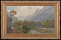 Clinton River Valley showing Wicks Mountains to right in view towards McKinnon Pass (Oil, John Elder Moultray about 1910, Auckland Museum).
![The Hirere Falls on the Milford Track are on the south western extreme of the Wick Mountains. The peaks behind at up to 1,920 metres (6,300 ft) do not have official names.[1]](http://upload.wikimedia.org/wikipedia/commons/thumb/e/e2/Milford_Track_Hirere_Falls.jpg/90px-Milford_Track_Hirere_Falls.jpg)

References
- ^ a b c d e NZTopoMap:Wick Mountains
- ^ a b Dowling, P. (ed.) (2004). ’’Reed New Zealand atlas’’. Auckland: Reed Publishing. Map 89. ISBN 0 7900 0952 8
- ^ New Zealand Gazetteer:Wick Mountains Source: Reed, A.W. & Peter Dowling, Place Names of New Zealand, 2010
- ^ a b A Wandres; SD Weaver; D Shelley; JD Bradshaw (1998). "Diorites and associated intrusive and metamorphic rocks of the Darran Complex, Mount Underwood, Milford, southwest New Zealand". New Zealand Journal of Geology and Geophysics. 41 (1): 1–14. doi:10.1080/00288306.1998.9514786.
- ^ NZ 1:250K Geological GNS science
- ^ "ClimbNZ:Wick Mountains (80 routes)". Retrieved 15 March 2023.
- ^ "ClimbNZ:Mt Moir (27 routes)". Retrieved 15 March 2023.
- v
- t
- e
Fiordland, New Zealand
- Big Bay
- Martins Bay
- Pearl Harbour
- Te Waewae Bay
- Anchor Island
- Arran Island
- Bauza Island
- Bay Rock
- Belle Vue Island
- Breaksea Island
- Brig Rock
- Buncrana Island
- Centre Island
- Chalky Island
- Coal Island
- Cooper Island
- Elizabeth Island
- Great Island
- Indian Island
- Long Island
- Pomona Island
- Resolution Island
- Secretary Island
- Hawea (Clio Rocks)
- Kahukura (Gold Arm)
- Kutu Parera (Gaer Arm)
- Moana Uta (Wet Jacket Arm)
- Piopiotahi (Milford Sound)
- Taipari Roa (Elizabeth Island)
- Taumoana (Five Finger Peninsula)
- Te Awaatu Channel (The Gut)
- Te Hapua (Sutherland Sound)
- Te Tapuwae o Hua (Long Sound)
- Darran Mountains
- Franklin Mountains
- Humboldt Mountains
- Hunter Mountains
- Kepler Mountains
- Murchison Mountains
- Wick Mountains
- Mitre Peak
- Mount Edgecumbe
- Mount Grono
- Mount Luxmore
- Mount Moturau
- Mount Richardson
- Mount Titiroa
- Mount Tūtoko
- Aan River
- Arthur River
- Awarua River
- Big River
- Bowen River
- Camelot River
- Carrick River
- Castle River
- Cavendish River
- Cleddau River
- Clinton River
- Coal River
- Dark River
- Donne River
- Doon River
- Dry Awarua River
- Edith River
- Eglinton River
- Electric River
- Elizabeth River
- Forgotten River
- George River
- Glaisnock River
- Gray River
- Grebe River
- Gulliver River
- Hollyford River
- Irene River
- John o'Groats River
- Juno River
- Kaipo River
- Light River
- Lyvia River
- Mike River
- Misty River
- Monowai River
- Namu River
- Newton River
- Olivine River
- Pandora River
- Pitt River
- Pyke River
- Rea River
- Red Pyke River
- Rooney River
- Seaforth River
- Shag River
- Spey River
- Stillwater River
- Talbot River
- Thurso River
- Transit River
- Tūtoko River
- Waiau River
- Waikōau River
- Wairaurāhiri River
- Waitutu River
- Walker River
- Wapiti River
- Whitewater River
- Wild Natives River
- Wilmot River
- Wilson River
- Windward River
- Wolff River
- Manapouri
- Milford Sound
- Port Craig
- Te Anau


