Sankt Jakob im Rosental
Pour les articles homonymes, voir Sankt Jakob.

Cet article est une ébauche concernant une localité autrichienne.
Vous pouvez partager vos connaissances en l’améliorant (comment ?) selon les recommandations des projets correspondants.
| Sankt Jakob im Rosental | ||||
 Héraldique | ||||
 | ||||
| Administration | ||||
|---|---|---|---|---|
| Pays |  Autriche Autriche | |||
| Land |  Carinthie Carinthie | |||
| District (Bezirk) | Villach-Land | |||
| Maire | Guntram Perdacher (SPÖ) | |||
| Code postal | A-9184 | |||
| Immatriculation | VL | |||
| Indicatif | 43+ (0) 4253 | |||
| Code Commune | 2 07 22 | |||
| Démographie | ||||
| Population | 4 245 hab. ([1]) | |||
| Densité | 54 hab./km2 | |||
| Géographie | ||||
| Coordonnées | 46° 32′ 48″ nord, 14° 03′ 28″ est | |||
| Altitude | 480 m | |||
| Superficie | 7 877 ha = 78,77 km2 | |||
| Localisation | ||||
| Géolocalisation sur la carte : Autriche
Géolocalisation sur la carte : Autriche
Géolocalisation sur la carte : Carinthie
| ||||
| Liens | ||||
| Site web | www.st-jakob-rosental.gv.at | |||
modifier  | ||||


Sankt Jakob im Rosental (en slovène : Šentjakob v Rožu) est une commune (Marktgemeinde) autrichienne du district de Villach-Land, en Carinthie.
Géographie
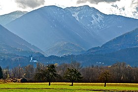
Le territoire communal s'étend du bord de la Drave au nord jusqu'aux hauteurs du massif des Karavanke dont la crête constitue la frontière entre l'Autriche et la Slovénie.
Histoire

Cette section est vide, insuffisamment détaillée ou incomplète. Votre aide est la bienvenue ! Comment faire ?

Références
- ↑ « Einwohnerzahl 1.1.2018 nach Gemeinden mit Status, Gebietsstand 1.1.2018 », Statistik Austria (en) (consulté le )
v · m Communes dans le district de Villach-Land | ||
|---|---|---|
 | ||
 Portail de l'Autriche


